Download
1 / 8
80 likes | 218 Views
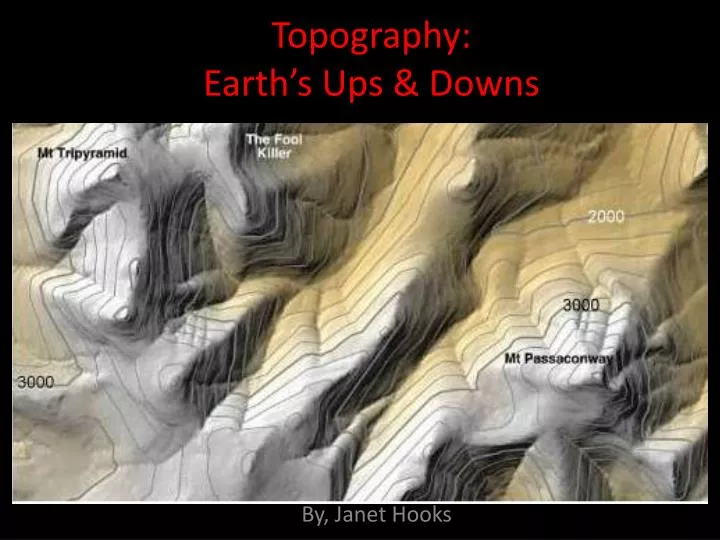
Topography: Earth’s Ups & Downs. By, Janet Hooks. You just learned about watersheds. Y ou know that the DIVIDES , of a watershed are areas of high elevation, like mountains or hills. Find the DIVIDES of this watershed.

E N D
Topography:Earth’s Ups & Downs By, Janet Hooks
You just learned about watersheds. You know that the DIVIDES, of a watershed are areas of high elevation, like mountains or hills. Find the DIVIDES of this watershed.
You also know that when it rains in a watershed (or when snow melts), the water travels downhill to form small rivers.Use your finger to trace the path of the small rivers in this watershed.
The small rivers (called tributaries) bring water to a large main river.The main river brings water to a large body of water, like an ocean, gulf or bay.Find the MAIN RIVER in this watershed, and use your finger to trace its path to the ocean.
It is interesting to look at watersheds, or any part of Earth by using a TOPOGRAPHIC map.What is TOPOGRAPHY?TOPOGRAPHY is the LANDSCAPE.Topographic maps show Earth’s landscape in a way so you can see the high and low areas of Earth’s surface.
Topographic maps use CONTOUR LINES to show changes in elevation (height) of the land.
When you read a topographic map, the contour lines help you see a 3-dimensional view of the land.
Every point on a contour line has the same elevation . Contour lines separate uphill fromdownhill. The closedshape inside a group of contour lines is the TOPof a mountain or hill. Contour lines are close together onsteep sloping land(hard to climb). Contour lines are farther apart onflatter land (less steep). Rules for Reading Topographic Maps: