Download
1 / 7
80 likes | 215 Views
2009 NSDI Cooperative Agreements Program. FGDC Coordination Group Meeting November 4, 2008. 2009 NSDI Cooperative Agreements Program. Opened October 10 Closes January 6 7 categories 26 proposals may be awarded Funds available $1,310,000 Awards will be made in February 2009.

E N D
2009 NSDI Cooperative Agreements Program FGDC Coordination Group Meeting November 4, 2008
2009 NSDI Cooperative Agreements Program Opened October 10 Closes January 6 7 categories 26 proposals may be awarded Funds available $1,310,000 Awards will be made in February 2009
FY2009 NSDI CAP Need volunteers for the proposal review in January Starting thinking and developing ideas for 2010 CAP categories, will need first cut of ideas in the spring 2009
FY2008 NSDI CAP Highlights Projects 25 Completed 2 Cancelled 1 Incomplete
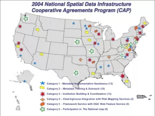
FY2008 NSDI CAP Highlights Completed Geospatial Strategic and/or Business Plans for the States of Wyoming, Vermont, Florida, Connecticut, California, West Virginia, Louisiana, Minnesota, South Dakota, Iowa, Missouri, Indiana Indiana Geographic Information Council return on investment (ROI) study demonstrated that over $1.7 billion in Indiana projects and programs are supported by the IndianaMap More than 30 metadata workshops trained over 500 individuals from across the US in a wide variety of organizations South Carolina created a central gateway to geospatial information called mySCmap Minnesota, South Dakota, and North Dakota partnered to promote shared client framework development and data services among themselves and their local government organizations With a partnership between Ohio State agencies and the Federal Government, Ohio published a WMS for high-resolution imagery to the GIServOhio portal, The National Map, and the Geospatial One-Stop portal Michigan's Western Upper Peninsula Planning & Development Region established a regional geospatial framework organization and have made geospatial data for the region discoverable via GOS
NSDI CAP For more information: http://www.fgdc.gov/grants/ Gita Urban-Mathieux burban@fgdc.gov, 703-648-5175