Download
1 / 1
10 likes | 99 Views
Strategic Approaches to the Restoration of the Passaic River Watershed: Comparing the Scale of Available Properties to Wetland and Buffer Area Required to Reduce Pollutant Loads. Conclusions.

E N D
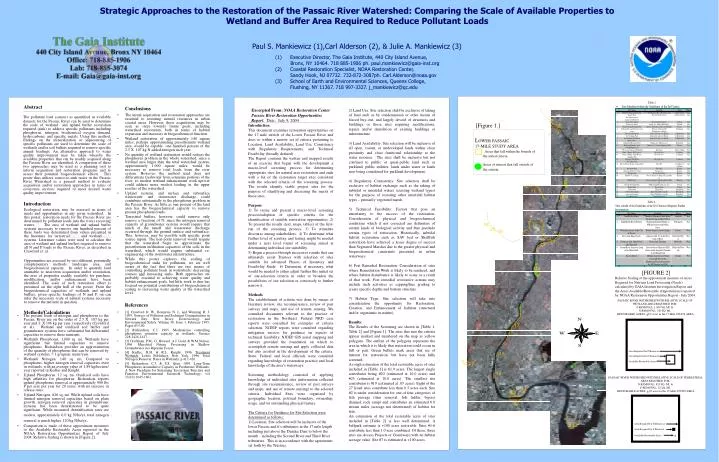
Strategic Approaches to the Restoration of the Passaic River Watershed: Comparing the Scale of Available Properties to Wetland and Buffer Area Required to Reduce Pollutant Loads Conclusions • The initial acquisition and restoration approaches are essential to restoring natural resources in urban coastal areas. However, these acquisitions may be seen as steps towards future goals, including watershed restoration, both in terms of habitat expansion and increases in biogeochemical function. • Wetland restoration of approximately 140 square miles, perhaps approximating presettlement wetland area, would be capable one hundred percent of the 2.5 X 10⁷ kg N added nitrogen each year. • No quantity of wetland restoration would redress the phosphorus problem in the whole watershed, since a wetland area larger than the total watershed system, approximately 1,000 square miles, would be necessary to remove total loads from the river system. However, the method used does not differentiate freshwater from estuarine portions of the river, so modest wetland enhancement work upriver could address more modest loading in the upper reaches of the watershed. • Upland systems, and surface and subsurface wastewater and stormwater discharge could contribute substantially to the phosphorus problem in the Passaic River. As little as one percent of the land area has the biogeochemical capacity to remove present phosphorus loads. • Terrestrial buffers, however, could remove only remove a fractions of N, since the nitrogen removal capacity of groundwater systems would require that much of the runoff and wastewater discharge occurred through the ground surface and subsurface. This, however, may be possible with specific point source inputs. The non-point removal would require that the watershed begin to approximate the presettlement infiltration capacities of the soils in the watershed, which would require substantial re-engineering of the stormwater infrastructure. • While this poster explores the scaling of biogeochemical sinks for pollutants, we are well aware of the fact that there are two means of controlling pollutant loads in watersheds: decreasing sources and increasing sinks. Both approaches are probably essential to achieving water quality and habitat enhancement goals, but little work to date has focused on potential contributions of biogeochemical scaling to increasing water quality at the watershed level. Abstract The pollutant load (source) as quantified in available datasets for the Passaic River can be used to determine the scale of wetland and upland buffer restoration required (sink) to address specific pollutants including phosphorus, nitrogen, biochemical oxygen demand, hydrocarbons, and specific metals. Using this method, findings on the mineralization or sequestering of specific pollutants are used to determine the scale of wetlands and/or soil buffers required to remove specific annual loadings. An alternative approach to water quality improvement may be taken whereby the available properties that can be readily acquired along the Passaic River are identified. A comparison of these two approaches may be used as a planning tool to inform acquisition and restoration programs and to assess their potential biogeochemical effects. This poster thus utilizes source-to-sink ratios in the Passaic River Watershed as a general method to evaluate acquisition and/or restoration approaches in terms of ecosystem services required to meet desired water quality improvement. [Figure 1.] LOWER PASSAIC 17-MILE STUDY AREAAreas that fall within the bounds of the stated criteria. Areas of interest that fall outside of the criteria. 1 1 2 3 Area Required for N Removal . Available Restorable Acres Introduction Area Required for P Removal Ecological restoration may be assessed in terms of needs and opportunities in any given watershed. In this poster, restoration needs for the Passaic River are determined by pollutant loads into the rivers receiving waters[1]. The area of wetland and upland buffer systems necessary to remove one hundred percent of these loads was determined from values presented in the literature for terrestrial[2][3] and wetland[4][5] systems. Literature values were used to calculate the area of wetland and upland buffers required to remove all N and P loads to the Passaic River, as described in Crawford et. al. Opportunities are assessed by two different, potentially complementary methods: landscape area, and biogeochemical capacity. In order to quantify land amenable to near-term acquisition and/or restoration, the area of properties readily available for purchase, modification, and/or enhancement have been identified. The scale of such restoration effort is presented on the right half of the poster. From the biogeochemical capacities of wetlands and upland buffers, given specific loadings of N and P, on can infer the necessary scale of natural systems necessary to remove the nutrient in question. 26 4 [FIGURE 2] Relative Scaling of the approximate measure of Acres Required for Nutrient Load Processing (Needs) calculated by GAIA Institute Investigation Report and the Acres Available/Restorable (Opportunities) reported by NOAA Restoration Opportunities Report - July 2004. 5 References • [1] Crawford D. W., Bonnevie N. L. and Wenning R. J. 1995. Sources of Pollution and Sediment Contamination in Newark Bay, New Jersey. Ecotoxicology and Environmental Safety. Volume 30, Issue 1, February 1995, Pages 85-100. • [2] Richardson, C.J. 1985. Mechanisms controlling phosphorus retention capacity in wetlands. Science 228:1424-1427. • [3] Groffman, P.M., G. Howard, A.J. Gold, & W.M.Nelson. 1996. Microbial Nitrate Processing in Shallow Groundwater in a Riparian Forest. • [4] Kadlec, R.H. & R.L. Knight. 1996. Treatment Wetlands. Lewis Publishers, New York. 1996. Total Nitrogen Removal Rates in Wetlands, p 417-420. • [5] Richardson, C.J. & S.S. Qian. 1999. Long-Term Phosphorus Assimilative Capacity in Freshwater Wetlands: A New Paradigm for Sustaining Ecosystem Structure and Function. Environmental Science& Technology: vol 33(10):1645-1661. PASSAIC RIVER WATERSHED WITH RELATIVE SCALE OF WETLAND AREA REQUIRED FOR:P REMOVAL: 1,000 SQ. MI. & N REMOVAL: 140 SQ. MI. RESTORABLE ACRES: +102 acres in the 17-Mile STUDY AREA 6 Methods/Calculations • The present loads of nitrogen and phosphorus to the Passaic River are on the order of 2.5 X 10⁷ kg per year and 3 X 10⁶ kg per year, respectively (Crawford et al). Wetland and oxidized soil buffer and groundwater systems have substantial but differential capacities to remove these nutrients. • Wetlands Phosphorus. 1,000 sq. mi. Wetlands have significant but limited capacities to remove phosphorus. Richardson provides an approximation of the quantity of phosphorus that can be removed by wetland systems, ≈ 1 g/square meter/year. • Wetlands Nitrogen. 140 sq. mi. Compared to phosphorus, higher nitrogen removal capacities exist in wetlands, with an average value of 1.89 kg/hectare/ year reported in Kedlac and Knight. • Upland Phosphorus. 12 sq. mi. Oxidized soils have high affinities for phosphorus. Richardson reports upland phosphorus removal at approximately 900 lbs P per acre per year for 20 years, with no increase in release rates. • Upland Nitrogen. 820 sq. mi. While upland soils have limited nitrogen removal capacities based on plant growth, nitrogen removal capacities in groundwater systems has been demonstrated to be quite significant. While measured denitrification rates are modest, approximately 6.0 kg N/ha/yr, total nitrogenremoval is much higher, 120 kg N/ha/yr. • Comparison is made of these approximate measures to the Available Restorable Acres reported in the NOAA Restoration Opportunities Report of July 2004. Relative Scaling is shown in [Figure 2]. 7 PASSAIC RIVER WATERSHED WITH RELATIVE SCALE OF TERRESTRIAL AREA REQUIRED FOR:N REMOVAL: 820 SQ. MI. & P REMOVAL: 12 SQ. MI. RESTORABLE ACRES: +102 acres in the 17-Mile STUDY AREA Area Required for N Removal . Area Required for P Removal Available Restorable Acres 1 Paul S. Mankiewicz (1),Carl Alderson (2), & Julie A. Mankiewicz (3) (1) Executive Director, The Gaia Institute, 440 City Island Avenue, Bronx, NY 10464. 718 885-1906 ph. paul.mankiewicz@gaia-inst.org (2) Coastal Restoration Specialist, NOAA Restoration Center, Sandy Hook, NJ 07732. 732-872-3087ph. Carl.Alderson@noaa.gov (3) School of Earth and Environmental Sciences, Queens College, Flushing, NY 11367. 718 997-3327. j_mankiewicz@qc.edu • Excerpted From: NOAA Restoration Center • Passaic River Restoration Opportunities Report. Date: July 9, 2004 • Introduction • This document examines restoration opportunities on the 17-mile stretch of the Lower Passaic River and does so within a narrow set of criteria pertaining to Location, Land Availability, Land Use, Consistency with Regulatory Requirements, and Technical Feasibility (broadly defined). • The Report contains the written and mapped results of an exercise that began with the development a macro-level screening process for determining appropriate sites for natural area restoration and ends with a list of the restoration target sites consistent with the selected criteria of the screening process. The results identify viable project sites for the purpose of identifying and discussing the merits of those sites. • Purpose • 1) To create and present a macro-level screening process/adoption of specific criteria for the identification of suitable restoration opportunities. 2) To present the results (text, maps, tables) of the first-run of the screening process. 3) To stimulate discourse among stakeholders. 4) To determine what further level of scrutiny and testing might be needed under a next level round of screening aimed at determining individual site suitability. • 5) Begin a process through successive rounds that can ultimately assist Trustees with selection of sites suitable for advanced Phases of Inventory and Feasibility Study. 6) Determine, if necessary, what would be needed to either adjust further this initial set of site-selection criteria in order to broaden the possibilities of site selection or conversely to further narrow it. • Methods • The establishment of criteria was done by means of literature review, site reconnaissance, review of past surveys and maps, and use of remote sensing. We consulted documents relevant to the practice of restoration in the Northeast. Federal NRD case reports were consulted for examples of criteria selection. NJDEP reports were consulted regarding mitigation success for guidance on aspects of technical feasibility. NJDEP GIS aerial mapping and surveys provided the foundation on which to accomplish remote sensing and apply collected data but also assisted in the development of the criteria. State, Federal and local officials were consulted regarding knowledge of restoration practice and local knowledge of the area’s waterways. • Screening methodology consisted of applying knowledge of individual sites (information collected through site reconnaissance, review of past surveys and maps, and use of remote sensing) to the selected criteria. Individual Sites were organized by geographic location, political boundary, ownership, usage, and /or outstanding physical feature. • The Criteria for Guidance for Site Selection were determined as follows: • 1) Location: Site selection will be inclusive of the lower Passaic and it's tributaries in the 17 mile length including just above the Dundee Dam to below the mouth - including the Second River and Third River tributaries. This is in accordance with the agreements set forth by the Trustees. 2) Land Use: Site selection shall be exclusive of taking of land such as by condemnation or other means of forced buy–out, and largely devoid of structures and buildings or those sites requiring modifications, repairs and/or demolition of existing buildings or infrastructure. 3) Land Availability: Site selection will be inclusive of all open, vacant, or undeveloped lands within close proximity and close functional relationship to the water resource. The sites shall be inclusive but not confined to public or quasi-public land such as parkland, public utilities, lands under water or lands now being considered for parkland development. 4) Regulatory Consistency: Site selection shall be exclusive of habitat exchange such as the taking of subtidal or intertidal waters (existing wetland types) for the purpose of restoring other intertidal habitat types – primarily vegetated marsh. 5) Technical Feasibility: Factors that pose an uncertainty to the success of the restoration. Consideration of physical and biogeochemical conditions which if not corrected are delimiters of certain kinds of biological activity and thus preclude certain types of restoration. Historically, subtidal habitat restoration such as SAV bed or Shellfish restoration have achieved a lesser degree of success than Vegetated Marshes due to the greater physical and biogeochemical constraints presented in urban waterways. 6) Post Remedial Restoration: Consideration of sites where Remediation Work is likely to be rendered, and where habitat disturbance is likely to occur as a result of that work. Post remedial restorative actions may include such activities as capping/fine grading to create specific depths and bottom structure. 7) Habitat Type: Site selection will take into consideration the opportunity for Restoration, Creation, and Enhancement of habitats (structural and/or organismic in nature). Results: The Results of the Screening are shown in [Table 1, Table 2] and [Figure 1]. The sites that met the criteria appear marked and numbered on the map as yellow polygons. The outline of the polygons represents the area in which it is likely that restoration could occur in full or part. Green bullets mark areas that are of interest for restoration, but have not been fully screened. A rough estimation of the total restorable acres of sites included in [Table 1] is 61.9 acres. The largest single contributor being #20 (estimated at 10.0 acres) and #23 (estimated at 10.0 acres). The smallest site contributor is #19 (estimated at .05 acres). Eight of the 27 listed sites contribute less than 0.5 acres each. Site #2 is under consideration for one of four categories of fish passage (dam removal, fish ladder, bypass channel, rock ramp) and contributes an estimated 6.0 stream miles (acreage not determined) of habitat for fish. An estimation of the total restorable acres of sites included in [Table 2] is less well determined. A ballpark estimate is +100 acres restorable. Sites #1-6 contribute less than 1.0 acre combined. Of these, three sites are Access Projects or Greenways with no habitat acreage value. Site #7 is estimated at +100 acres.