Download
1 / 27
270 likes | 277 Views
Clouds, shear and the simulation of hybrid wind lidar. S. Wood and G. D. Emmitt Simpson Weather Associates WGSBWL Miami 2007. Role of Clouds. Clouds and aerosols enable and confound profiling of winds from space

E N D
Clouds, shear and the simulation of hybrid wind lidar S. Wood and G. D. Emmitt Simpson Weather Associates WGSBWL Miami 2007
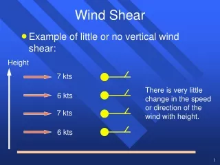
Role of Clouds • Clouds and aerosols enable and confound profiling of winds from space • NASA funded study of GLAS data to investigate the effects of clouds on the vertical distribution of lidar data • Primary issues being addressed currently • General cloud distributions, particularly cirrus • Clouds and shear (using OSSE Nature Runs) • Clouds porosity (optical)
Lidar design issues • The instrument accuracy of direct detection lidars for Doppler and DIAL are proportional to the number of photons detected. For molecular lidars, clouds are a source of error. If “integration on a chip” is employed, individual cloud returns contaminate the entire integration interval. • Coherent detection lidars have the properties of threshold accuracy (i.e. instrument accuracy does not change much above some threshold of detected coherent photoelectrons). Sensitivity, however, is a function of the total number of PEs. • For both detection techniques, the total observation error is dependent on the number and spacing of the samples. • Total error = Sqrt( instrument error2 + representative error 2)
GLAS Study • ESTO/NASA funded effort to use the GLAS data to gain insight into the patterns of CFLOSs (Cloud Free Line Of Sight) for input to the design of future space-based lidars (altimeters, Doppler, DIAL, LaserCom, imagers) • Specific questions: • What percent of the time are there clouds in a laser beam’s FOV? Single layer? Multiple layers? • What percent of the time is a ground return detected? • What are the statistics on consecutive CFLOSs down to different levels in the atmosphere? Number of CFLOSs within a specified distance?
GLAS on ICESat • Ice, Cloud and land Elevation Satellite • Geoscience Laser Altimeter System • Launched 13 January 2003 • GLAS lidar • Nd:YAG at 1064 and 532 nanometers • 75 mJ at 1064 & 35 mJ at 532 • 40 PRF • 1 meter aperture • 70 meter footprint with 175 meter between shots
Land vs. water Note: Using High resolution product (8 combined shots)
Summary • Based upon the GLAS data, between 75 and 80% of lidar shots intercept clouds. • GLAS data suggest that 70-80% of its shots reach the surface. • Given that the EAP for the GLAS instrument was modest compared to lasers being planned for future missions, it is expected that both cloud and ground returns will increase in the future.
Summary(2) • ~ 30% of all integrated data products detected 2 or more layers of clouds when any cloud is present. • While integrating over longer distances may improve sensitivity, it does not improve the probability of CFLOS integration. • Although GLAS has provided the first global laser cloud statistics based upon more than a few hours of operation (i.e.LITE), CALIPSO promises an even better data set for use in the design of future lidars (DWL, DIAL, LaserCom).
Nature Run Clouds • Use T213 & GSFC’s FVGCM Nature Runs • How do the Nature Run clouds compare to the ISCCP findings? • How do high cirrus effect simulated DWL observations in OSSEs? • How are shear and clouds correlated in Nature Run? • How does a “porosity” factor alter the distribution of simulated hybrid (coherent subsystem only) DWL products?
Simulated transmission of DWL lidar beam through cirrus as represented in Nature Run
The Instrument • Hybrid technology Doppler Lidar • Direct (molecular) detection for cloud free volumes and low aerosol loadings (mainly mid/upper troposphere and lower stratosphere) • Coherent detection for cloudy regions and “enhanced” aerosol loadings (mainly partly cloudy regions and PBL) • Use of both systems returns better data quality and coverage with smaller critical instrument components (lasers and telescopes) than single technology approaches • ISAL/IMDC (NASA/GSFC) • November/December 2006 review of instrument concepts and mission scenarios with feasibility and cost conclusions
Performance modeling • The DWL community has available tools for simulating future DWL instrument and mission concepts • Doppler Lidar Simulation Model (DLSM/SWA) • Observing System Simulation Experiments (OSSEs by NOAA, NASA & DoD; NPOESS/IPO major funding) • Nature Runs are used as truth • Performance profiles • Generated by running DLSM on Nature Runs • Summarizes vertical coverage of the simulated DWL data products and their accuracy • Uses “background” and “enhanced” aerosol distributions to bracket performance • Much emphasis on clouds
GWOS with background aerosol mode Coherent Direct GWOS with enhanced aerosol mode Coherent Direct
Dual Technology Sampling • The coherent subsystem provides very accurate (< 1.5m/s) observations when sufficient aerosols (and clouds) exist. • The direct detection (molecular) subsystem provides observations meeting the threshold requirements above 2km, clouds permitting. • When both sample the same volume, the most accurate observation is chosen for assimilation. • The combination of direct and coherent detection yields higher data utility than either system alone. Note that in the background aerosol mode, the combination of the coherent and direct provide ~ 20 % more coverage near 3 -5 km than could either technology by itself.
GWOS with background aerosol mode Dual sampling with the coherent and direct detection molecular Global Wind Observing Sounder (GWOS) GWOS with enhanced aerosol mode Green represents percentage of sampled volumes when coherent subsystem provides the most accurate LOS measurement; Yellow is for direct detection; Gray is when neither system provides an observation that meets data requirements
Background aerosol mode GWOS synergistic vector wind profiles* Enhanced aerosol mode Green: both perspectives from coherent system Yellow: both perspectives from direct molecular Blue: one perspective coherent; one perspective direct * When two perspectives are possible
Cloud Porosity No clouds 0% porosity 100% porosity 50% porosity
Porosity Summary • For the coherent subsystem of the hybrid DWL, the vertical coverage of the data products meeting the requirements are reasonably “cloud proof”. • A remaining issue is how the utility of cloud returns (actual horizontal motion of the cloud particles) differs from those from the adjacent aerosols.
Plans • Calibration of CMV heights with lidar • CALIPSO CFLOS statistics • OSSEs to develop DAS techniques for optimizing synergisms between Ocean Vector Wind and Cloud Motion Vectors • OSSEs to explore the use of DWL observations in hurricane track and intensity forecasting.