Download
1 / 1
10 likes | 132 Views
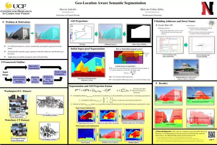
Geo-Location Aware Semantic Segmentation. Shervin Ardeshir Shervin@knights.ucf.edu University of Central Florida. Malcolm Collins-Sibley c ollins-sibley.k@husky.neu.edu Northeastern University. GIS Projections:. Building Addresses and Street Names Google Maps API. Problem & Motivation:

E N D
Geo-Location Aware Semantic Segmentation ShervinArdeshir Shervin@knights.ucf.edu University of Central Florida Malcolm Collins-Sibley collins-sibley.k@husky.neu.edu Northeastern University GIS Projections: • Building Addresses and Street Names • Google Maps API • Problem & Motivation: • Use GIS information to extract semantically meaningful segments from the image. • Automatically annotate image segments with their addresses and absolute geo-locations. • Applications in mobile navigation such as Google Glass • Street Names: • A grid of points is generated covering the area not covered by the buildings. • The street names associated to each point on the grid is extracted using Maps API • Building Addresses: • The Google Maps API is used to convert GIS information into street names and addresses GIS Map Building Projection Binary Map of Building Initial Super-pixel Segmentation How to find initial segment scores? Example binary map Input Image Alignment using Horizon Street Grid Points After name classification Street Grid points after occlusion handling • Framework Outline: Super-pixel Segmentation Example image post segmentation • The score for each super-pixel is defined by the percentage of it’s pixels which are covered by the binary map • = Set of pixels within super-pixeli • = super-pixelicovered by the binary map Markov Chain Propagation Building & Street Binary Maps & Addresses GIS Projections and Occlusion Handling Building addresses as well as street names are shown overlaid here Initial Super-Pixel Segmentation (Randomly Colored) • Results: Washington D.C. Dataset: Segmentation and GIS Projection Fusion Forcing each super-pixel to belong to a projection Geo-tagged images from Panoramio Single Segment Optimization: GIS Building Outlines Building Segment after Thresholding Final Scores after Markov Iterations Initial Super-Pixel Scores Waterbury CT Dataset: Multi-Segment Joint Optimization: • Acknowledgments: This work was completed as part of the REU (Research Experience for Undergraduates) at The University of Central Florida, under the supervision of Dr. Mubarak Shah and Dr. Neils de Vitoria Lobo. • Entropy Rate SuperpixelSegmentation Ming-Yu Liu, OncelTuzel, SrikumarRamalingam, and Rama Chellappa • Proceedings of the IEEE Conference on Computer Vision and Pattern Recognition (CVPR'11) , Colorado Spring, Colorado, June 2011. • Shervin Ardeshir, Amir RoshanZamir, Alejandro Torroella, Mubarak Shah. GIS-Assisted Object Detection and Geospatial Localization. ECCV 2014 • Barinova O, Lempitsky V, Tretiak E, Kohli P. Geometric Image Parsing in Man‐Made Environments. European Conference on Computer Vision, 2010 GIS Building Outlines Geo-tagged images from Panoramio Building & Street Segments CRCV Street Segment Building Segment