Download
1 / 4
40 likes | 202 Views
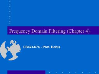
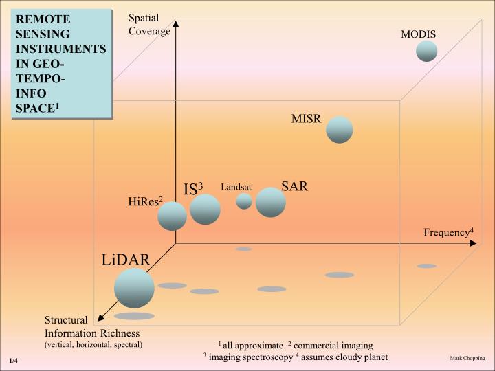
Spatial Coverage. REMOTE SENSING INSTRUMENTS IN GEO- TEMPO- INFO SPACE 1. MODIS. MISR. SAR. IS 3. Landsat. HiRes 2. Frequency 4. LiDAR. Structural Information Richness (vertical, horizontal, spectral). 1 all approximate 2 commercial imaging

E N D
Spatial Coverage REMOTE SENSING INSTRUMENTS IN GEO- TEMPO- INFO SPACE1 MODIS MISR SAR IS3 Landsat HiRes2 Frequency4 LiDAR Structural Information Richness (vertical, horizontal, spectral) 1 all approximate 2 commercial imaging 3 imaging spectroscopy 4 assumes cloudy planet Mark Chopping 1/4
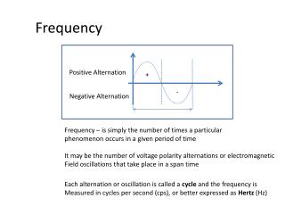
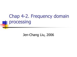
Spatial Coverage WHAT ARE THEY GOOD FOR wrt the NACP and JNACP? MODIS monthly: anything fast-moving, disturbance/recovery history, phenology, LUC3, (LAI/fPAR)… MISR seasonal: disturbance, canopy cover, height, biomass, LUC3, (LAI/fPAR)… annual: disturbance, cover, LUC3… + annual LAI, foliar chemistry, soil/PV/NPV… SAR IS1 Landsat annual: disturbance, cover, structure… Frequency2 LiDAR annual/multi-annual: canopy cover, height & structure, biomass, disturbance… Structural Information Richness (vertical, horizontal, spectral) 1 imaging spectroscopy 2 assumes cloudy planet 3 assumes large area mapping capability Mark Chopping 2/4
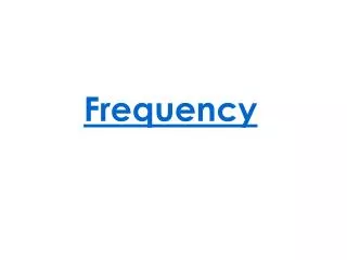
Spatial Coverage REMOTE SENSING INSTRUMENTS IN GEO- TEMPO- INFO SPACE THAT PROVIDE 3-D STRUCTURAL INFORMATION vs. MODIS/Landsat (MODIS1) MISR SAR (Landsat) Frequency LiDAR Structural Information Richness (vertical, horizontal) 1 MODIS may also provide some structural information (e.g. SSI) Mark Chopping 3/4
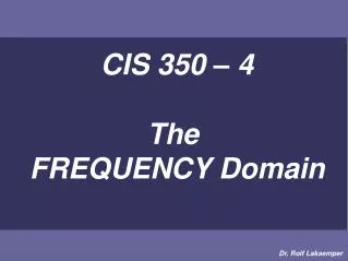
Spatial Coverage REMOTE SENSING INSTRUMENTS IN GEO- TEMPO- INFO SPACE1 MODIS MISR Availability* High SAR IS3 Landsat HiRes2 Frequency4 LiDAR Low Structural Information Richness (vertical, horizontal, spectral) *ease of access/use and $$$ (anticipated thru’ 2010)1all approximate 2commercial imaging 3imaging spectroscopy 4assumes cloudy planet Mark Chopping 4/4