Download
1 / 21
210 likes | 308 Views
HydroView: An Infrastructure Program for Hydrologic Science. Jon Duncan, Communications Director Consortium of Universities for the Advancement of Hydrologic Sciences, Inc. Who is CUAHSI?. A consortium of 88 research universities and 1 affiliate member

E N D
HydroView: An Infrastructure Program for Hydrologic Science Jon Duncan, Communications DirectorConsortium of Universities for the Advancement of Hydrologic Sciences, Inc.
Who is CUAHSI? • A consortium of 88 research universities and 1 affiliate member • Incorporated June, 2001 as a non-profit corporation in Washington, DC
What does CUAHSI do? • Serve hydrologic science community • Develop community goals • Identify needs • Advise NSF • Operate community programs • Manage infrastructure • Develop program ideas
HydroView • Initial program • Mutually supportive elements • Observatories • Instrumentation • Informatics • Synthesis
Current Status • Synthesis: SoI under review; proposal to be submitted Fall, 2004. • Informatics: Pilot program begun with $2.5M, 2-year grant • Instrumentation: Proposal about to be submitted for 3-yr pilot • Observatories: Pilot 5-station network to be started in 2005
Today’s Briefing • Focus on HO’s • Design concepts • Next steps in implementation • Management questions
Design Concepts for HO’s • Community Resource • Core data available to all through common interface • Equal access to site • Support for remote investigators • Sufficiently Large • Explore all interfaces, include LS/Atm • Contribute to hydrologic improvement in GCM’s • National-scale Network • Comparable data across observatories • Test hypotheses in different hydrologic settings
Science Topics • Linking Hydrologic and Biogeochemical Cycles • Hydrologic Extremes • Sustainability of Water Resources • Transport of Chemical and Biological Contaminants • Hydrologic Influence on Ecosystem Functions
Cross-cutting Themes • Scaling • Forcing, Feedbacks, and Coupling • Predictions and Limits-to-Prediction
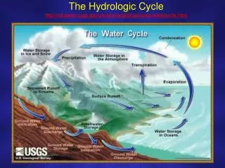
Hydrologic Characterization Three fundamental properties • Fluxes between “stores” • Residence time within “stores” • Flowpaths among “stores” Stores include surface, subsurface and atmosphere.
Core Data • Provides estimates of fundamental characteristics • Common to multiple hypotheses • Immediately available to community
HO Development • Local perspective • Design data necessary to address chosen hypotheses • Designate “core” data and “first-publication” data • Network perspective • Provides common data model • Determines metadata standards • Influences core data collection
Observatory Design Team • Determines best way to “characterize” site • Delineates “core data” boundary • Develops workplan for data collection • HO Standing Committee reviews plan
HO Professional Staff • Implements workplan developed by observatory design team (ODT) • Populates common data model • Provides site management to coordinate research by ODT and others • Collects non-core data as resources permit
Evaluation Criteria—1 • Hypotheses Posed • Meet at least 3 of 5 topics • Interdisciplinary • Innovative • Design • Provides characteristics across range of scales, including largest • Combination of nested, intensive basins with broader surveys
Evaluation Criteria—2 • Leveraging of Existing Data • Intensive studies (LTER, USGS, ARS, USFS) • Monitoring data sets (Federal, state and local) • Institutional support • State/Local support • Stakeholder organizations • Educational/Outreach Opportunities
Two Perspectives • Local Design Team • Choose hypotheses • Rewarded by pursuing “their” science • Just one research team—do not control site • Broader Community • Site must attract non-local scientists • Broad range of disciplines
Next Steps • Aug. 1, 2004: 10-page prospectus • Aug. 23, 2004: National Workshop • Fall, 2004: Regional Workshops • Jan, 2005: NSF Program Announcement • Apr, 2005: Proposals Due • Sep/Oct 2005: Award 2 HO’s • 2008: Competition for 3rd HO
National Workshop • Choose 5 “example” basins for hypothetical HO Network from submitted prospectuses • Day 1 • AM: HIS, Neuse, HMF presentations • PM: Poster session and election • Day 2: Breakout groups by basin (core data composition) and by science topic (cross-observatory hypothesis testing) • Selection of basins has no meaning beyond workshop
Regional Workshops • Held Sep – Dec, 2004 • CUAHSI creates 5 hydrologic regions • Open to everyone (including non-hydrologists!) • Objectives • Build community support • Learn about potential sites in region • Support level: $20K/wkshp
HO Management • “2 PI” model • Ensures ODT does not control site • Divides community responsibility from individual science endeavor • Site director? • 1 PI Model • Integrates ODT and Site Director • Integral science model