Download
1 / 13
130 likes | 133 Views
ROMANIAN ACADEMY INSTITUTE OF GEOGRAPHY Dimitrie Racovi ţă Str., 12, Sect. 2, RO-70307-Bucharest-20, ROMANIA Tel. 004 021 3135990, 3143748; Fax. 004 021 3111242; E-mail: igar @ geoinst .ro. LAND USE AND HUMAN PRESSURE IN THE GETIC PIEDMONT. Ana Popovici, Dan Bălteanu,

E N D
ROMANIAN ACADEMY INSTITUTE OF GEOGRAPHY Dimitrie Racoviţă Str., 12, Sect. 2, RO-70307-Bucharest-20, ROMANIA Tel. 004 021 3135990, 3143748; Fax. 004 021 3111242; E-mail: igar@geoinst.ro LAND USE AND HUMAN PRESSURE IN THE GETIC PIEDMONT Ana Popovici, Dan Bălteanu, Monica Dumitraşcu, Mihaela Sima
Objectives • to evaluate the current land use; • to analyse the main causes of land degradation; • to identify potential “hot-spots” in terms of land degradation. • Data sources • statistical data (Romanian Statistics Yearbook 1990-2007, Agricultural Farm Survey 2005, General Agricultural Censu 2002); • cartographical data (Corine Land Cover data-base for 1990, 2000 and 2006, geomorphological maps, maps of present-day processes, flood hazard maps); • field surveys of significant areas.
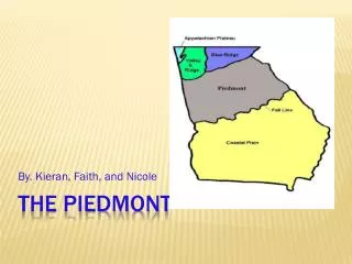
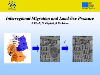
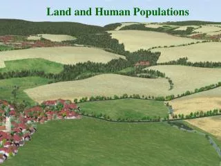
Study area • 13,820 km² • Limits: Danube River (west); Dâmboviţa River (east); Getic Subcarpathians (north); Romanian Plain (south). • A piedmont area - transition from the Subcarpathian Hills in the north to the Romanian Plain in the south. • Main relief features: steady north-to-south altitudinal fall (from over 700 m to 90–100 m); high relief fragmentation in the north, with many slope degradation processes, while in the south and central prevail the flat areas, with higher human pressure. Geographical position of the Getic Piedmont
Population density in the Getic Piedmont (2007) • over 2,400,000 inhabitants (2007)
Land use changes-induced land degradation Source: Corine Land Cover, 2006 Land cover/Land use in the Getic Piedmont Land cover/land use structure, 2006 Structure of agricultural land, 2006
Land use changes-induced land degradation Land use changes over the post-socialist period • transition from the concentrated land property to an excessive fragmentation of the land and from large to small peasant type family households. Main changes: • changes in the property typeof agricultural and forest lands (Land Law 18/1991) • changes in the type of farms Negative impact • excessive fragmentation of agricultural land; • very high proportion of subsistence individual farms; • poor development of services in agriculture (mechanization, fertilization, irrigation, etc.); • increase of land degradation. • climate change (intensification of climate extreme events – droughts, floods, landslides, etc.)
17,1% 20,4% 10,9% 52,7% 10,4% 66,8% 16,5% 5,2% > 2 2 - 5. 5. - 50 < 50 > 2 2 - 5. 5. - 50 < 50 Excessive fragmentation of agricultural land Arable land before and after Land Law 18/1991 came into effect in the Cotmeana Piedmonta) 1990, b)2000 b. a. Following enactment of the Land Law, arable land became extremely fragmented. The proportion of very small parcels (under 2 ha) increased from 20.4% (1990) to over 66.8% (2000), while the very large ones (over 50 ha) decreased from 52.7% (1990) to under 18% (2000). b.
Individual farms, number and average area/farm , 2005 Very high proportion of subsistence individual farms • 71,721 farms (2005) – of which 99.5% are individual farms, 0.5% are juristic person units; • the predominance of small and very small farms, owned by poorly educated, elderly people who moreover have little money; • very small average size of agriculturalfarms (the average agricultural area/individual farmis 1.8 ha); • most individual farms practice subsistence agriculture, the products being destined to the farmer’s own consumption needs; • very many parcels / farm (3–6 parcels) and long distance between their location and one’s household • These characteristics lead to impossibility for these farms to be competitive and use the agricultural terrain in a sustainable manner. Farms by class size of agricultural area used (ha), 2005
Poor and/or arbitrary fertilisation of crops Areas prone to nitrate pollution, 2008 • Increase the agro-chemical deterioration of soil • Poor fertilization of crops • Arbitrarily application of chemicals Source: Research Institute for Soil Science and Agrochemistry, 2008
Land degradation induced by present-day geomorphological processes (landslides and erosion) Landslide susceptibility classes in the Getic Piedmont • The manifestation of present-day geomorfological processes differentiates from north to south, in terms of relief features and geological make-up (mostly alternations of sands, clayey sands, marls and gravels). • sheet and gully erosion and landslides predominate in the northern part of the Piedmont; • - in the south of the Piedmont prevail the less intense erosion, dominant man-induced soil compaction and acidification, where there are large agricultural lands.
Technological hazards and land degradation • the chemical industry (chlorine from Slatina, ammonia from Drobeta Turnu-Severin and Turceni); • the mining industry (in the north-west of the Getic Piedmont (Motru-Rovinari area) and in the central part of the Olteţ Piedmont); • accidental pollution with hydrocarbons and other hazardous substances (Olteţ, Cotmeana and Cândeşti Piedmonts); • damage to hydrotechnical structures (the Olt and the Arges rivers), etc.
Conclusions • There are several areas seriously degraded: • Motru Piedmont (north-eastern part): coal industry, high susceptibility to landsliding and gully erosion • areas surround the southern cities (Drobeta Turnu-Severin, Craiova, Slatina and Piteşti-Mioveni): polluting industries, household and industrial waste sites, and oil residue. • east of the Jiu River (pollution from oil residue), etc. • Uncontrolled dumping of domestic refuse on the river banks, or in some steeps at the edge of the forest or inside it. • After 1990, global climate warming and change in the use of land intensified extreme climatic phenomena (draughts, floods and landslides). At the same time, erosional processes becoming severer, certain areas are undergoing serious land degradation. • Apart from the natural factors (climate, landform, rock and vegetation), man is significantly involved in the intensification of erosion processes (deforestations, excess grazing, plouging along the slope, plowing the permanent pastures and hay-fields, building roads on slope, etc.).