Download
1 / 14
140 likes | 349 Views
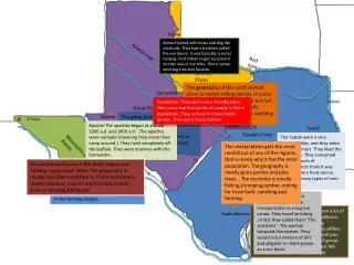
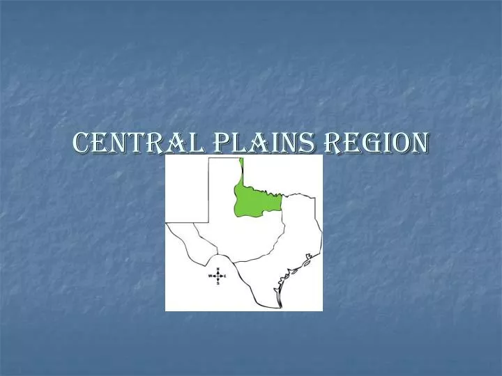
Central Plains Region. 3 Subregions. The Grand Prairie Purple The Cross Timbers Green The Rolling Plains Orange. The Grand Prairie. Covered by grasses, shrubs, and small trees Grasslands are suitable for raising cattle, goats, hogs, poultry, and sheep

E N D
3 Subregions • The Grand Prairie • Purple • The Cross Timbers • Green • The Rolling Plains • Orange
The Grand Prairie • Covered by grasses, shrubs, and small trees • Grasslands are suitable for raising cattle, goats, hogs, poultry, and sheep • This area has an agricultural economy but the thin soil limits crop production. Corn, oats, sorghum, and hay are grown as animal feed.
The Grand Prairie • Fort Worth is by far the largest city in the Grand Prairie and is also the largest city in the Texas Central Plains. • The city plays a vital role in the subregions economy. • With come of the busiest railyards in the nation.
The Grand Prairie • Fort Worth is a transportation center, or place where goods arrive to be shipped to many destinations. • The city is also an major processing center for livestock and farm products. • Fort Worth specializes in the manufacture of airplanes, electronics equipment and helicopters.
The Cross Timbers • Two belts of forestland made up the Cross Timbers: The Eastern Cross Timbers and the Western Cross Timbers. • The Western Cross Timbers lies west of the Grand Prairie. • The Eastern Cross Timbers is smaller (15 miles across) and located between the Grand Prairie and the Blackland Prairie
The Cross Timbers • When farmers moved into the region, the cut down many trees. • Some of the native forest vegetation can still be found, however. • The Eastern Cross Timbers contains some elms, hickories, and post oaks.
The Cross Timbers • Blackjack oak, cedar hickory, mesquite, pecan and post oak trees all grow in the drier Western Cross Timbers. • The sandy soil of the Cross Timbers absorbs water well, making it particularly good for farming.
The Cross Timbers • Farmers grow crops ranging from peanuts to corn, cotton and hay. • Ranchers raise cattle, horses and sheep there. • Since 1917, the subregion has also provided Texas with energy resources such as oil and natural gas.
The Cross Timbers • The Eastern Cross Timbers cuts the Metroplex in half, running between Dallas and Fort Worth. • Cities such as Denton have manufacturing plants. • While the Western Cross Timbers has no large cities, its towns include Brownwood, Mineral Wells and Weatherford.
The Rolling Plains • Located in the westernmost part of the Central Plains. • Prairie grasses cover most of its hilly terrain • The thin soil of the subregion also supports some brush , hardwood trees and mesquite trees.
The Rolling Plains • The Rolling Plains subregion is particularly well suited for cattle ranching. • Steep valleys provide shelter for cattle, while grasslands and their rivers provide them with food and water. In areas with poorer vegetation, ranches raise goats and sheep.
The Rolling Plains • When there is good farmland, farmers grow cotton, sorghum, and wheat. • The Rolling plains are also a source of oil and natural gas.
The Rolling Plains • The population of the Rolling Plains is much smaller than that of subregions in eastern Texas. • Abilene and Wichita Falls are its largest cities. • Both cities have meat and dairy processing facilities and serve as distribution centers for this subregion. • Small market towns are also scattered throughout the ares.