Download
1 / 7
70 likes | 167 Views
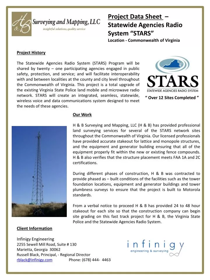
Project Data Sheet – Statewide Agencies Radio System “STARS” Location - Commonwealth of Virginia. Project History

E N D
Project Data Sheet – Statewide Agencies Radio System “STARS” Location - Commonwealth of Virginia Project History • The Statewide Agencies Radio System (STARS) Program will be shared by twenty – one participating agencies engaged in public safety, protection, and service; and will facilitate interoperability with and between localities at the county and city level throughout the Commonwealth of Virginia. This project is a total upgrade of the existing Virginia State Police land mobile and microwave radio network. STARS will create an integrated, seamless, statewide, wireless voice and data communications system designed to meet the needs of these agencies. “ Over 12 Sites Completed ” Our Work H & B Surveying and Mapping, LLC (H & B) has provided professional land surveying services for several of the STARS network sites throughout the Commonwealth of Virginia. Our licensed professionals have provided accurate stakeout for lattice and monopole structures, and the equipment and generator building ensuring that all of the equipment properly fit within the new or existing fence compounds. H & B also verifies that the structure placement meets FAA 1A and 2C certifications. During different phases of construction, H & B was contracted to provide phased as – built conditions of the facilities such as the tower foundation locations, equipment and generator buildings and tower plumbness surveys to ensure that the project is built to Motorola standards. From a verbal notice to proceed H & B has provided 24 to 48 hour stakeout for each site so that the construction company can begin site grading on this fast track project for H & B,the Virginia State Police and the Statewide Agencies Radio System. Client Information Infinigy Engineering 2255 Sewell Mill Road, Suite # 130 Marietta, Georgia 30062 Russell Black, Principal, - Regional Director rblack@infinigy.com Phone: (678) 444- 4463
Project Data Sheet – Gloucester CountyRadio Communication System Location – Gloucester County, Virginia Project History • Gloucester County, Virginia in conjunction with Infinigy Engineering and Motorola Communications has undertook a county wide update of the 911 communication system. This upgrade consisted in building 275’ to 300’ self – supporting lattice towers along the Route # 17 corridor and throughout Gloucester County, Virginia. • This project consisted of building and as-building the towers to Motorola standards. Client Information Infinigy Engineering 2255 Sewell Mill Road, Suite # 130 Marietta, Georgia 30062 Russell Black, Principal, - Regional Director rblack@infinigy.com Phone: (678) 444- 4463 Our Work • H & B Surveying and Mapping, LLC (H & B) provided as-built tower conditions for five structures along the Route # 17 Corridor of Gloucester County, Virginia. • Our project sites consisted of – • Abington Elementary School - Site # 173-057 • Gloucester Animal Shelter - Site # 173-058 • Gloucester Landfill - Site # 173-059 • Beaver Dam Park - Site # 173-060 • Gloucester ECC - Site # 173-061 • H & B utilized our TOPCON GPT 3103 reflectorless instrument to accurately locate the center of each leg at each structure elevation lift. H & B collected a set of angles and reflectorless distances to each joint location of the tower as to ensure the location of each structure joint. While in the field, our crews located the same joint from multiple locations to have redundancy in each location which insured a tighter precision of measurement at each location on the structure. • Once the field surveying was complete and the integrity was checked in the field, the data was checked by a licensed professional and the data was processed utilizing Carlson Survey Software. This data was imported into a spreadsheet developed by H & B to calculate the twist and plumbness of the structure based on the calculation sheet provided by Motorola Communications.
Project Data Sheet – High Definition Scan of High Wall at Leesburg Quarry Location – Leesburg Virginia Our Work • H & B Surveying and Mapping, LLC (H & B) was requested to provide conventional cross-sections of a high wall at Luck Stone Corporation - Leesburg Quarry and a reflectorless image of the wall. The cross - sections were surveyed utilizing our Topcon GPT – 3103W reflectorless Total Station while our Topcon “IS” image Station was robotically collecting thousands of points on the high wall for additional engineering analysis. • How the project was complete – • The Topcon “IS” image station was set up and collected panoramic images of the wall and then was set up to collect survey grade points on a 1’ by 1’ grid. • While the “IS” was collecting data, our survey crew established additional baseline points where the actual surveyed cross-sections were to be gathered at approximately 90° to the face of the wall. • One of our Licensed Professional collected information on the baseline points in our “Carlson CE – Data Collector”, then began collecting reflectorless survey grade points from the top of the wall to the base of the wall ensuring that all undulations along the wall would be gathered and process in Cross – Section format. • Once the “IS” completed the first image scan the “IS” was moved to the opposite end of the wall and a second scan was collected in order to have overlapping data. Finally an Third scan was collected in the middle of the base line to have additional redundant data. While the conventional survey was being collected the “IS” was collecting over 60,000 points with little or no additional work on the crews behlf. • All “IS” scan information was processed with “Image Master” and a point cloud of the data was delivered in .dwg format. • The conventional cross-section data was process utilizing “Carlson Survey Software”. Top View of “Point Cloud Image” Client Information Luck Stone Corporation 515 Stone Mill Drive Manakin Sabot, Virginia 23103 Joe Carnahan, P.E. - Mining Engineer jcarnahan@luckstone.com Phone: (804) 476 - 6433
Project Data Sheet – Topographic Survey for Buildings C7 / C8 and C9 / C10 Fort Lee Military Base Location – Hopewell, Virginia Our Work • This project was fast track project to perform as – built conditions of the adjoining construction projects. The location consisted of newly constructed roadways, storm and sanitary sewer systems, planimetric physical features such as water valves, fire hydrants, electric and communication hand holes and junction boxes as well as newly erected light poles. H & B utilized the Loyola RTK – Net to collect the ground surface for approximately 80 % of the topographic area. We utilized a conventional survey crew to collect the physical and all hard scape features as to ensure the accuracy of the elevations on pavement and other features that are critical to the design of this project. • The data was downloaded on a daily basis and the field crews field verified the work from the previous day as to keep the project on schedule and to provide phased deliveries to our client. • The topographic survey was collected in a Carlson “Field to Finish” approach which is where our crew chiefs acts as the field cad technician collecting line work and symbol placement as the feature is being collected in the field. The final office processing was completed with Carlson “Civil Suite” The Final Product The final product for this project was an AutoCAD Civil 3d cad product of which H & B delivered an AutoCAD drawing and Land XML data file which import directly into AutoCAD. • Project Highlights • Multiple Construction Site • Completed in Two Weeks • Fast Track Project / Phased Delivery • Utilized RTK – Net for Ground Topo Client Information WileyWison 515 Stone Mill Drive Manakin Sabot, Virginia 23103 Joe Carnahan, P.E. - Mining Engineer jcarnahan@luckstone.com Phone: (804) 476 - 6433
Project Data Sheet – Red Hill Farm – Boundary & ALTA / ACSM Survey Location – Loudoun County, Virginia • Project Highlights • 297.59 acres (Three Parcels) • Conventional & GPS Location • Completed in Four Weeks • Fast Track Project • ALTA / ACSM Standards Our Work • This project was a fast track project of preparing an ALTA / ACSM Survey for three parcels of property in Loudoun County, Virginia consisting of 297.59 acres. This project was performed utilizing exiting aerial mapping and the aerial mapping was updated as a part this ALTA / ACSM survey. The location of property monumentation was performed utilizing in two different manners; 1) in open areas H & B utilized the Loyola RTK – Net to locate property corners or set pairs of control in order locate physical features from conventional traverses. If the RTK – net was used for property monumentation location then each point was located more than one time to ensure that ALTA ACSM Standards were meet for positional tolerance. The RTK – Net was also utilized to locate the centerline of the roadway for the prescriptive R/W and physical features such as fence lines, limits of pond and centerline of streams, 2) conventional traverse control was utilized in woods areas as to make certain that the positional tolerance for each property monument was meet as a part of this survey. The conventional traverse was tied to GPS control points that was set using RTK – Net. The Final Product The final product for this project was 1) an ALTA ACSM Survey that was mapped and platted to ALTA Standards and in a format to be recorded in Loudoun County, Virginia, 2) a recordable easement plat showing “Riparian Area” throughout the project site based on design plans as provided by Falling Springs, LLC. Client Information Fallings Spring, LLC 1100 Boulders Parkway Richmond, Virginia 23225 James Parker - Project Manager jparker@fallingspringsllc.com Phone: (804) 330 - 1136
Project Data Sheet – Boundary / Subdivision Plat for TRi BE CA Brownstones – PHASE II Location – Richmond, Virginia Our Work • This project consisted of the following task – • Detailed courthouse research for baseline and utility maps as well as ownership for each parcel adjoining the proposed subdivision site. • Property reconnaissance survey was performed to find existing property monumentation along S. Harrison Street, Idlewood Ave., Wallace Street and S. Randolph Street. Property monumentation consisted of block corners, “X”’s in concrete sidewalks, lead plugs with tacks in the concrete sidewalks and iron pins. • A conventional closed traverse was done as a part of the boundary survey as to meet specification for minimum standards and procedures for Land Surveying in the Commonwealth of Virginia. • Topographic mapping was performed on this site to produce a contour map at a finished mapping scale of 1” = 30’ with a one foot contour interval. • As-built surveys were performed on the combined sanitary sewer system of which consisted of obtaining accurate invert and pipe size information within the structure. • Project Highlights • Property Survey of • One City Block • Part of a Revitalization • Project for RRHA • Conventional & GPS Surveys • Completed in Two Weeks The Final Product The final product for this project is a Subdivision Plat and Topographic Survey in a format to be recorded in the City of Richmond, Virginia. Client Information Johannas Design Group 1901 W. Cary Street Richmond, Virginia 23220 David Johannas - Architect dave@johannasdesign.com Phone: (804) 358 - 4993
Project Data Sheet – Topographic Survey for A Portions of the Piedmont Geriatric Hospital Facility Location – Burkeville, Virginia • Project Highlights • Eight Topographic Areas Being Merged • Into Existing Aerial Mapping • Multiple Topographic Sites for New • Parking Lots and Drainage Improvements • Completed in ThreeWeeks • Phased Deliveries Our Work • This project was to perform as – built conditions of eight different topographic areas so that the existing aerial mapping topographic survey can be updated and current. This project. consisted of locating the roadways, storm and sanitary sewer systems, planimetric physical features such as water valves, fire hydrants, electric and communication hand holes and junction boxes as well as lighting features. H & B utilized the our TOPCON “IMAGING STATION” to collect the ground surface for approximately 80 % of the topographic area The IMAGE STATION is a robotic total station with a built – in high definition scanner. This instrument allowed H & B staff to survey and scan images as the survey was being performed in a field to finish approach. We utilized a conventional survey crew to run the approximate two miles of traverse control of which was translated to the existing control base of the aerial topographic survey. • The data was downloaded on a daily basis and the field crews field verified the work from the previous day as to keep the project on schedule and to provide phased deliveries to our client. • The topographic survey was collected in a Carlson “Field to Finish” approach which is where our crew chiefs acts as the field cad technician collecting line work and symbol placement as the feature is being collected in the field. The final office processing was completed with Carlson “Civil Suite” Client Information WileyWison 515 Stone Mill Drive Manakin Sabot, Virginia 23103 Joe Carnahan, P.E. - Mining Engineer jcarnahan@luckstone.com Phone: (804) 476 - 6433 The Final Product The final product for this project was an AutoCAD Civil 3d cad product of which H & B delivered an AutoCAD drawing and Land XML data file which import directly into AutoCAD.