Download
1 / 19
190 likes | 196 Views
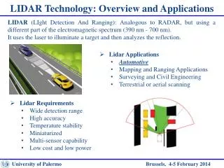
Lidar at the TRCA Applications and Uses for a Conservation Authority. Business Units using Lidar. Development Planning and Regulation Planning Ecology Enforcement Archaeology Research and Climate Programs Watershed Studies & Strategies Community Engagement Property & Land Management

E N D
Lidar at the TRCAApplications and Uses for aConservation Authority
Business Units using Lidar • Development Planning and Regulation • Planning Ecology • Enforcement • Archaeology • Research and Climate Programs • Watershed Studies & Strategies • Community Engagement • Property & Land Management • Restoration & Regeneration • Engineering Services • Flood Plain Mapping • Erosion Management • Capital and Special Projects
Floodplain Mapping • 1D vs 2D modelling • Lidar detects minute changes in elevation • Highly detailed DEMs
Intensity Mapping • Lidar collects x/y/z, rbg, and intensity values • Intensity is the amount of light energy reflected back from surface • Create raster with intensity values • Impervious surfaces (asphalt, concreate, buildings) darker than pervious • Use remote sensing techniques to isolate impervious vs non-impervious • In rural areas drainage features can be detected
Planning and Development • See terrain and detail beneath forest cover • Connect disconnected feature over the landscape • Measure slope and see trends over a site • Demonstrate forest connectivity • Show terrain in 3D and add developments plans
Thanks!http://camaps.maps.arcgis.com/apps/MapJournal/index.html?appid=f92aabd42f5144d8895989b8bb46a7aaThanks!http://camaps.maps.arcgis.com/apps/MapJournal/index.html?appid=f92aabd42f5144d8895989b8bb46a7aa