Download
1 / 57
580 likes | 586 Views
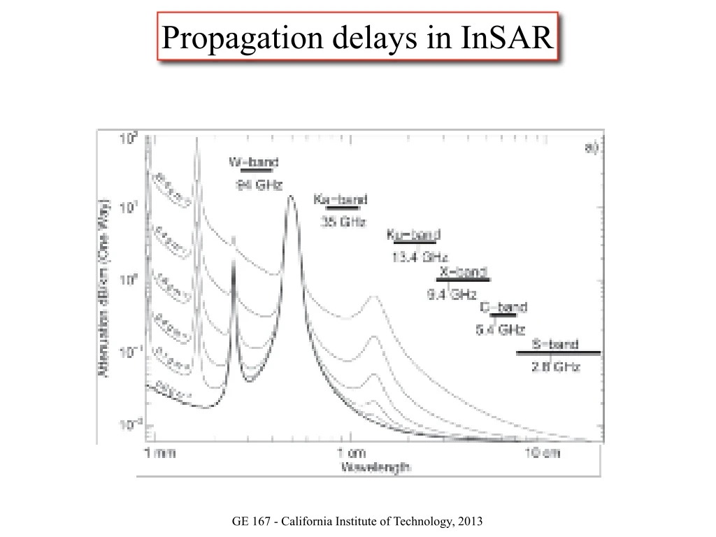
Propagation delays in InSAR. GE 167 - California Institute of Technology, 2013. Propagation delays in InSAR. TerraSAR-X CosmoSkyMed. Envisat ERS-1/2 RadarSat Sentinels. Kollias et al, 2007, BAMS. An example. - One month temporal baseline (no deformation)

E N D
Propagation delays in InSAR GE 167 - California Institute of Technology, 2013
Propagation delays in InSAR TerraSAR-X CosmoSkyMed Envisat ERS-1/2 RadarSat Sentinels Kollias et al, 2007, BAMS
An example... - One month temporal baseline (no deformation) - Topography <=> Atmospheric delay
Differential delay First pass Second Pass
First pass Second Pass Differential delay
A bit of theory Air Refractivity: Refraction index : Total Pressure : Temperature : Cloud Water Content : Electron Density : Frequency : Constants
A bit of theory Air Refractivity: : Total Pressure : Temperature : Cloud Water Content : Electron Density Real-life range : Frequency - Small perturbation - Very hard to estimate : Constants Hanssen, 2001
A bit of theory Air Refractivity: : Total Pressure : Temperature : Cloud Water Content : Electron Density Real-life range : Frequency - Small perturbation - Very hard to estimate : Constants Hanssen, 2001
A bit of theory Air Refractivity: : Total Pressure : Temperature - Dispersive effect - Long wavelength perturbations (~100 km) - Effect is small in C-band (too short wavelength) - Significant in L-band : Cloud Water Content : Electron Density : Frequency : Constants
Ionospheric perturbation Shen et al., 2009, Nat. Geosci.
Ionospheric perturbation “clean” Interferogram Azimuth offsets Phase gradient - Estimate the azimuth offset - Compute the phase gradient - Extract the proportionality factor - Correct the interferogram Problem: Only works where there is no deformation along azimuth Ionospheric phase screen Interferogram Raucoules & de Michele, 2010. IEEE GRSL
A bit of theory Air Refractivity: : Total Pressure : Temperature Ionosphere (not today) : Cloud Water Content : Electron Density Troposphere (today) : Frequency : Constants
A bit of theory Air Refractivity: and Nadir Delay: : Dry Air Pressure : Total Pressure : Temperature : Specific Constant for dray air and vapor : Cloud Water Content : Gravitation : Electron Density : Partial pressure in Water Vapor : Frequency : Constants
A bit of theory Delay along the Line-Of-Sight wrt. reference altitude: : Dry Air Pressure : Total Pressure : Temperature : Specific Constant for dray air and vapor : Cloud Water Content : Gravitation : Electron Density : Partial pressure in Water Vapor : Frequency : Constants
A bit of theory Delay along the Line-Of-Sight wrt. reference altitude: If I had a pressure profile...
A bit of theory Delay along the Line-Of-Sight wrt. reference altitude: ... and a temperature profile...
A bit of theory Delay along the Line-Of-Sight wrt. reference altitude: ... and a Water Vapor Partial Pressure profile...
A bit of theory Delay along the Line-Of-Sight wrt. reference altitude: ... I could compute the total delay:
A bit of theory Delay along the Line-Of-Sight wrt. reference altitude: ? ... I could compute the total delay: But usually, I don’t have all those things (actually, never...).
Do we really need to correct for that delay? Can’t we just filter it, or whatever?
Do we really need to correct for that delay? Can’t we just filter it, or whatever? Yes, you can...
Do we really need to correct for that delay? Can’t we just filter it, or whatever? Yes, you can... ... but you should not.
Single interferograms Mw 7.7 Depth ~ 100 km
Time filtering, then...? Stacking:
Time filtering, then...? Stacking: If we have independent interferograms, with random noise (in time)
Time filtering, then...? Stacking: If we have independent interferograms, with random noise (in time) Doin et al, 2009, J. App. Geophy.
Time filtering, then...? Stacking: If we have independent interferograms, with random noise (in time) Now that we can do better, still no!!!
How to correct then? Turbulent Delay Stratified Tropospheric Delay + ==> Stacking or Time Series - Random in Space and Time - Numerous Acquisitions to average or smooth the signal
2 Separating the delay Turbulent Delay Stratified Tropospheric Delay + ==> Stacking or Time Series
Separating the delay Turbulent Delay Stratified Tropospheric Delay + ==> Stacking or Time Series Semivariogram: Covariance:
Separating the delay Turbulent Delay Stratified Tropospheric Delay + ==> Stacking or Time Series
Empirical Correction Estimating a phase/elevation relationship
Empirical Methods Estimating a phase/elevation relationship Joint inversion model/orbit/troposphere Cavalie et al, 2008; Jolivet et al., 2012
Empirical Methods Estimating a phase/elevation relationship Joint inversion model/orbit/troposphere Cavalie et al, 2008; Jolivet et al., 2012
Empirical Methods Estimating a phase/elevation relationship Multi-scale approach Lin et al, 2010
Empirical Methods - Deformation/Topography correlation
Prediction Methods - Most methods focus on constructing vertical profiles of delay Available Data: GPS zenith delays Local Atmospheric data Multi-spectral imagery systems Global Re-analysis Available Methods: Interpolation (2D / 3D / Ray tracing) Meso-scale modeling
Prediction Methods Local Atmospheric Data - Data from a meteorological station - Radio sounding profile Delacourt et al. 1998, GRL
Prediction Methods GPS zenith delays Onn & Zebker, 2006, JGR
Prediction Methods GPS zenith delays Onn & Zebker, 2006, JGR
Prediction Methods Multispectral Images • Multi-spectral imagery system onboard Envisat: • - Passive system (captures the electro-magnetic field reflected by the ground surface) • - 15 Bands • - Combination of band 14 and 15 gives the Integrated Precipitable Water Vapor • - Integrated Wet delay and and : Specific Constant for dray air and vapor : Ratio of molecular masses of water vapor and dry air : Constants Puyssegur et al, 2007, JGR; Li et al, 2012, GJI
Prediction Methods Multispectral Images Good: Does not only correct for stratified features Predicts turbulence Bad: Does not work for night-time acquisitions Does not work if dense cloud cover Li et al, 2012, GJI
Interferogram MM5 Modeling Prediction Methods Meso-Scale Modeling Goal: Reproduce the turbulences using fine modeling Puyssegur et al, 2007, JGR
Prediction Methods Available Data: GPS zenith delays Local Atmospheric data Multi-spectral imagery systems Global Re-analysis These data are not always available This is fine over SoCal, but Tibet is another story ERA-Interim Dee et al, 2011 - ECMWF atmospheric model - Global ~75 km grid - 1989-... - 4 solutions a day at 0 am, 6 am, 12 pm and 6 pm - Altitude, temperature and water vapor partial pressure at 37 pressure levels (surface to 50 km alt.)
Computing Delay Maps from GAM 1 - Computing delay functions
Computing Delay Maps from GAM 1 - Computing delay functions 2 - Spatial bilinear interpolation and spline interpolation for altitude
Computing Delay Maps from GAM One month temporal baseline == no deformation expected