Download
1 / 32
320 likes | 340 Views
Soil Resource Inventory Tool Box (SRITB). MO-13 Meeting April 17, 2008. What is SRITB?. Soil Resource Inventory Toolbox Initiative by Soil Survey Division to provide automated tools for field soil scientists. SRITB components:. Pedon PC Analysis PC Lab Database Entry Program

E N D
Soil Resource Inventory Tool Box (SRITB) MO-13 Meeting April 17, 2008
What is SRITB? • Soil Resource Inventory Toolbox • Initiative by Soil Survey Division to provide automated tools for field soil scientists
SRITB components: • Pedon PC • Analysis PC • Lab Database Entry Program • Editing Toolbar (ArcMap extension) • Soil scientist’s “My Toolbar” (desktop)
Analysis PC • Forms built in Microsoft Access • Links between Access and ArcMap
Analysis PC: • Analysis form: uses Access built queries to display selected sets
Laboratory Data Entry Program • Numerous universities, states, and other entities collect and store soil data • Lab Database Entry Program is an attempt to centralize this external data into our system
Editing Toolbar (SRITB 1.1.18) • Adds a suite of toolbars to ArcMap (loads as an extension) • Programmed to simplify GIS digitizing procedures and data capture. • Developed to increase the efficiency of field digitizing and data collection. • Designed to maximize screen real estate • Provide field scientists with enough GIS capability to make informed decisions in the field. • Digitizing standards are pre-set as the defaults so user does not have to know or understand all the details of these standards
Start Editing Stop Editing Save Edits Edit Manager Editor icons
Snapping environment Set Sticky Move Tolerance Set Stream Tolerance Set Snapping Distance Edit Manager Tolerance Settings icons
Streaming Sketch Reshape Edge Modify Edge Cut Polygon Create Island Polygon Merge Auto Complete Polygon Edit Toolbar Topology Editing Tools Editing Tools Editing Tools
Custom Edit ToolsSaving Keystrokes (Ex: Cutting Polygons) Cut Polygon • Out-of-the-Box ArcMap • Start Editing • Set task to Cut Polygon Features • Activate Select Features Tool • Select features • Activate Sketch Tool • Make cut • Explode multi-part features • Label features • SRITB Cut Polygon Tool • Activate Cut Polygon Mode • Select features • Make cut • Label features
Custom Edit ToolsImproving Quality • Proper tools to perform task are automatically selected • Using the wrong tools creates errors • Quality control is built-in
Add Ink Erase Ink Finish Ink Sketch Clear Ink Sketch Undo Ink Settings Sketch Toolbar Draw using a Thin pen
Planarize Lines Topology Edit Show Shared Features Validate Topology In Specified Area Validate Topology In Current Extent Validate Entire Topology Fix Topology Error Error Inspector Topology Toolbar Construct Features ! Topology is critical for data quality and integrity !
Extent Selection Finds Common Lines QC Toolbar in Version 1.1.18 Finds Minimum Sized Polygons Find And Fix Inspector
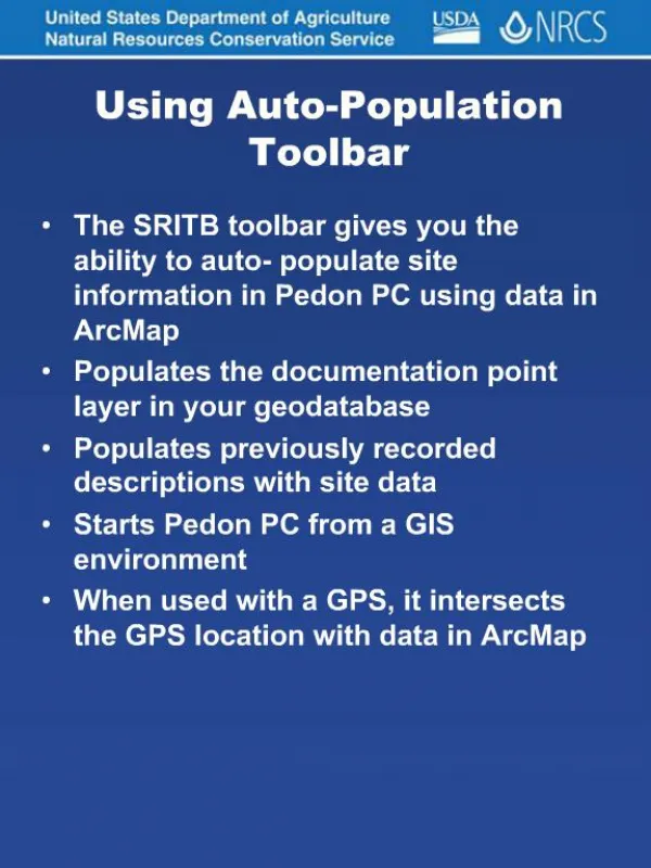
Auto- Populate From Current GPS Position Auto- Populate From Selected points Auto- Populate From Clicked location Connects GPS to Application Displays GPS Position On Screen Information On GPS Receiver Navigation Using GPS Close Connection Collect Point GPS Toolbar Pedon PCApplications
Setup Tools • Proper setup is critical to data quality • Setup Toolboxes simplify and bullet-proof setup and offer standardization • Two Options - initial or update survey • Options within options for different types of setup • Packaged separately from SRITB
My Toolbar (in development): Provides links to web and client applications that are relevant to soil science on a desktop toolbar