Download
1 / 30
300 likes | 431 Views
NATS 101-06 Lecture 16 Atmo-Ocean Interactions El Niño-Southern Oscillation. Summary . Global Circulation Differential Heating Between Tropics and Poles Three Cells: Hadley-Ferrel-Polar Mid-Latitude Westerlies Patterns shift slightly with seasons Precipitation

E N D
NATS 101-06Lecture 16Atmo-Ocean InteractionsEl Niño-Southern Oscillation
Summary • Global Circulation Differential Heating Between Tropics and Poles Three Cells: Hadley-Ferrel-Polar Mid-Latitude Westerlies Patterns shift slightly with seasons • Precipitation Major Deserts occur under Sub-Tropical High Mid-latitude storms occur along Polar Front
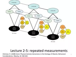
Ferrel Polar Pole Equator Hadley Triple Cell (~Real World) • Equator-to-Pole temperature difference and rotation of Earth produce 3 circulation cells Hadley Cell (Thermally Direct) Ferrel Cell (Indirect: Forced by Hadley & Polar) Polar Cell (Thermally Direct) Shift with Seasons
Global Circulation - Precipitation Ahrens Fig 13-2
Ocean Currents Drag from wind exerts a force on the ocean surface in the same direction as the wind. Currents of upper ocean are due to wind. Tend to flow in the direction of prevailing wind. Poleward currents are warm; equatorward currents are cold. Thus, oceans transport heat from the tropics to the poles, about the same amount of heat as the wind.
Ocean Currents of World Ahrens Fig. 7.24
Summer SST Along West Coast Sea surface temperatures (SST) along West Coast are quite cold during summer, especially off Northern California. Due to upwelling of cold, nutrient rich water by prevailing N winds. Prevailing Winds Coastal Surface Water Ahrens Fig 7.24
Ekman Spiral Ahrens, Older Ed. Surface water moves 45 to the right of prevailing wind. Subsurface water moves at angles greater than 45. Net transport of surface layer is 90 to the right. Coriolis force is responsible for the rightward rotation.
Upwelling from Alongshore Winds Ahrens Fig 7.25 Wind pushes surface water southward. Coriolis force deflects water to the right. Cold water from below rises to surface. Fog persists over the cold water.
El Nino 3.4 Upwelling Regions weather.unisys.com
El Nino-Southern Oscillation (ENSO) An important atmospheric-ocean feedback Normal conditions in tropical Pacific: -Warm SST, low SLP, and T-storms in W Pacific -Strong subtropical highs in E Pacific -Easterly winds and cool upwelling water along equator in East Pacific -Prevailing southerly winds off of Peru produce cold upwelling and excellent fishing
El Niño-Southern Oscillation (ENSO) Every few years (4-5 years): -Equatorial Central Pacific warms -Low SLP, T-storms shift to Central and East Pacific (the Southern Oscillation) -Trades and southerly winds off Peru weaken -Upwelling ceases off Peru, warming leads to massive kill off of fish. Typically occurs around Christmas (an El Niño event) Alters global patterns of wind, temp and rain
Walker Circulation Pushes water westward Darwin Tahiti Aguado & Burt, p230 Walker Circulation oscillates with a quasi-period of every few years. Oscillation is very evident in SLP records for Darwin and Tahiti.
Southern Oscillation Index (SOI) SST SLP
ENSO-Atmosphere Feedback Ocean temperature pattern Ocean currents, upwelling SLP, winds, storms, etc. By observing SST’s and surface winds in equatorial Pacific, we are able to forecast ENSO events with considerable skill. ENSO forecasts lead to skillful seasonal forecasts for the US several months in advance (e.g. 1997-1998 winter).
Summary • Major Ocean Currents Driven by prevailing wind • Upwelling Regions Occurs along west coasts of continents Cold water rises from below to surface Nutrient rich, excellent fishing regions
Summary • El Nino-Southern Oscillation Occurs every few years Central equatorial Pacific warms Low SLP, T-storms move with warm water Upwelling weakens along Peru coast Can be predicted up to one-year in advance Modulates global patterns of wind, temp, rain
Assignments • Following Lecture Topic -Air Masses Reading -Ahrens pg 201-212 Problems -8.1, 8.11