Download
1 / 14
140 likes | 148 Views
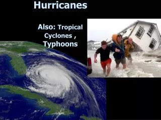
Doppler Lidar Winds & Tropical Cyclones. Frank D. Marks AOML/Hurricane Research Division 7 February 2007. NOAA TC Research Goals.

E N D
Doppler Lidar Winds & Tropical Cyclones Frank D. Marks AOML/Hurricane Research Division 7 February 2007
NOAA TC Research Goals • Advance understanding and prediction of tropical cyclones (TC) and other tropical weather by providing resources to address improvements to forecasts and warnings through use of observations, observing strategies, analysis, and evaluation. The goals of this research are to: 1. Advance prediction of TC intensity and structure change (INTENSITY); 2. Improve prediction of TC track (TRACK); 3. Enhance ability to diagnose and predict impacts of TC on life and property (IMPACTS); and 4. Improve understanding of and ability to predict TC frequency and intensity on longer time scales (SEASONAL). • http://www.aoml.noaa.gov/hrd/
Track • Sensitivity to environmental circulation beyond TC envelope • Current sampling of environment through targeted observations (dropsondes) and satellite cloud motion vectors (height assignment). • HRD (Aberson), NHC (Franklin) and colleagues at NCEP evaluate utility of observations on track forecasts. • Issues include: • poor data coverage in important areas, • data assimilation quirks with sparse data • inability to cover the necessary targets • temporal and spatial resolution (24 h, horizontal 100 km, 5-6 layers in vertical)
7 3 2 6 5 4 8 1 Synoptic Environment • Need to investigate role of Saharan Air Layer (SAL) in early tropical cyclone development and intensity change. • Accomplished 4 NOAA G-IV research experiments (SALEX) into 4 incipient tropical cyclones (TS Irene, unnamed TD in 2005 and TS Debby and Hurricane Helen in 2006).
10 15 5 SAL 1 20 26 Saharan Air Layer Experiment G-IV Mission 050807n
NE SW NE SW
Saharan Air Layer Experiment (SALEX) G-IV Mission 050807n Polar 1 10 15 SAL 3 SAL 2 5 1 SAL 1 Irene 20 AEW 1 25
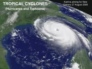
Intensity/Structure Vq Vr, w Airborne Doppler-analyzed wind field Hurricane Katrina, 28 September 2005 http://www.aoml.noaa.gov/hrd/Storm_pages/katrina2005/radar.html
Intensity/Structure • Sensitivity to environmental circulation outside TC core (shear, eddy flux, etc.) • Sensitivity to ocean boundary conditions, interactions, and changes along track • Sensitivity to inner core dynamics • Sampling of these regions limited by presence of heavy rain, clouds, strong winds. Rely on whatever we can get (i.e., radar, in-situ aircraft, satellite: microwave, IR, and visible) • Issues include: • poor data coverage in important areas, particularly in region surrounding core. • temporal and spatial resolution (3-6 h, horizontal 5-10 km, and 1 km vertical)
Intensity/Structure • Sensitivity to environmental circulation outside TC core (wind and pressure field) • Sensitivity to inner core dynamics (intensity) • Current sampling of these regions limited by presence of heavy rain, clouds, strong winds in the vicinity of the storm. Rely on whatever we can get (i.e., radar, in-situ aircraft, satellite: microwave, IR, and visible) • Issues include: • poor data coverage in important areas, particularly in region surrounding core. • temporal and spatial resolution (6-24 h, horizontal 50-100 km, at 1-3 layers in vertical)
How can a Doppler Lidar in Space help? • Track & Synoptic Environment: • provide regularly spaced data coverage in important areas surrounding TC for data assimilation into numerical models. • Need temporal resolution at least 12-24 h, horizontal resolution of 100 km, and vertical resolution of 1 km. • Accuracy to better than 1 m s-1 for mean wind surrounding TC (1 m s-1 error in mean wind yields 86.4 km track error in 24 h).
How can a Doppler Lidar in Space help? • Intensity: • improved vertical structure of environment surrounding and above core, particularly near tropopause for use in determining shear and eddy flux. • higher temporal resolution 6-12 h, horizontal resolution 25 km, vertical resolution <1 km. • Accuracy to 1 m s-1 for vertical shear in vicinity of TC - large differences in storm intensity change for small changes in vertical shear.
How can a Doppler Lidar in Space help? • Gale & hurricane force wind radii: • improved coverage of surface environment surrounding TC for use in defining wind and pressure field surrounding storm. • temporal resolution 12-24 h, horizontal resolution 25 km for gradients, higher vertical resolution in boundary layer (<1 km). • Accuracy to better than 1 m s-1 for wind surrounding TC - 1 m s-1 error in wind yields large error pressure gradient.
Summary • Space-based Doppler Lidar can make impact on TC forecasts and research through improved horizontal and vertical wind structure in storm environment. • Doppler Lidar does not need to provide data in core for significant impact. • Major advantages: • better temporal and spatial data coverage surrounding TC than currently possible with targeted observations and satellite cloud motion vectors. • higher vertical resolution especially useful near top and bottom of environment • improved accuracy of wind estimates