Download
1 / 20
230 likes | 639 Views
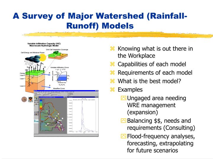
A Survey of Major Watershed (Rainfall-Runoff) Models. Knowing what is out there in the Workplace Capabilities of each model Requirements of each model What is the best model? Examples Ungaged area needing WRE management (expansion) Balancing $$, needs and requirements (Consulting)

E N D
A Survey of Major Watershed (Rainfall-Runoff) Models • Knowing what is out there in the Workplace • Capabilities of each model • Requirements of each model • What is the best model? • Examples • Ungaged area needing WRE management (expansion) • Balancing $$, needs and requirements (Consulting) • Flood-frequency analyses, forecasting, extrapolating for future scenarios
Consider this Scenario: What kind of Water Resources Management Strategy/Measures would be needed to ensure long-term water needs? 1. A major expansion of urbanization is planned in forested land – malls, apts, parks, industry 2. How will the planned urbanization change the response of the land to rainfall? Increase chances of floods? Flashier? Bring down GWT? Watershed Models are used to answer such questions
GOALS • Be aware of the Major Models out there and their basic workings • Understand Data needs and requirements • Merits/Demerits of Models (situational) • Ponder over: What is the Best Model? (open question) • Be able to make an informed decision on the choice of a Model (for Consulting, Industry, Public Works)
The Hydrologic Cycle All watershed Models (or Rainfall-Runoff) attempt to model the Hydrologic Cycle at the watershed scale. • Watershed? – Natural System with all major components of cycle • Hydrologic Cycle? (Water Cycle) – Water Distribution • Model? – Abstraction of reality using Mathematics
The Major Processes of a Model Infiltration Unsaturated Zone flow Groundwater (saturated zone flow) Overland Flow River Flow Evapotranspiration Rainfall is usually the major input in Hydrologic Models – it is not modeled!
Classification of Models Based on mathematical representation of processes • Conceptual Models • Physically-based Models Based spatial nature of input/output of models • Lumped Rainfall, Runoff, ET, GW flow • Distributed Rainfall, Runoff, ET, GW flow
Conceptual Vs Physically Based Conceptual Models – Idealization of processes as stores, buckets, parameterizations – simplified equations representing mass, momentum, energy. Physically-based Models – “rigorous numerical solution of partial differential equations governing flow through porous media, overland and channel flows. “
Lumped Vs Distributed Models Lumped - The spatial and temporal variation of meteorological, hydrological, geological and hydrogeological data across the model area is described as one aggregated value for input and output !All models are lumped at the finest scale! Distributed - The spatial and temporal variation of meteorological, hydrological, geological and hydrogeological data across the model area is described in gridded form for the input as well as the output from the model
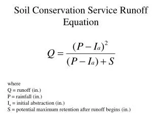
Data Requirements for Models • Rainfall Data (Major Input) • Soils Data (Infiltration, Runoff) • DEM – channel network (River routing) • Vegetation Data (For ET) • GWT Data (Saturated zone flow) • Historical Rainfall-Streamflow Data (Calibration) • Evaporation Data (ET) More Physically-based means more data requirement More Conceptual requires less data! Data acquisition is an investment that needs to be commensurate with the model
Sources of Data • Rainfall – Gage, Radar (NWS), Satellite • Soils – STATSGO, USDA • DEM – USGS, Topo maps, Satellites • Vegetation – Satellites, USDA • Streamflow – USGS • Reliability • Ready availability • Cost $$$ • Resolution (space, time)
Is all data needed? • Physically-based – Insatiable needs – but potential high returns • Conceptual – modest needs with modest returns • Calibration –needs historical data. What is Calibration? • What to do in ungaged regions where there is ‘No Data’? Transfer experience. PUB
What affects $$ operational costs of a Model? • Level of data needs – Data is expensive • Level of physical complexity (Physically-based means qualified personnel; Rational Method – no-brainer • Scale of the problem being addressed – larger/heterogenous – more $$$ The multiple needs of the TVA river reservoir system
Some Models Out there • HEC-1 • PRMS • HSPF (Fortran) • MIKE 11 • Make your own survey if you wish (Consider, DSS – Riverware, BASINS) For a comprehensive guide refer to: VP Singh – Computer Models for Watersheds
HEC-1 • Developed by Hydrologic Engineering Center (HEC) of US Army Corps of Engineers • Flood Hydrograph Package – single storm even simulation. Lumped model • Loss Function approach – SCS, Green Ampt, Holtan • Data Needs – sub-basin delineation, rainfall, runoff, routing parameters • Based on Unit Hydrograph or kinematic for runoff routing • Other capabilities – Snowfall/melt, dam safety, pumping, diversions • Customer Support? – Try HEC, San Diego, CA.
PRMS – Precipitation-Runoff Modeling System • Developed by USGS – more of an educational tool to build your own models • Lumped/sub-basin –continuous simulation – see Handout • Data needs – (depends) precip, streamflow, DEM, minmax air temp, radiation, vegetation..(see handout) • Code in F77 • Capabilities - many • Customer Support? – Try USGS
HSPF Hydrological Simulation Program - Fortran • USGS – multi-use model • Can do water quality. • Mainly for land-use change, reservoir operations, flow diversions etc. • Data needs – A lot – (see Hand-out) • Software – In Fortran 77 • Capabilities – A lot (see hand-out) • Customer Support? – Try USGS • Real Example – 62,000 sq mi tributary area in Chesapeake Bay.
MIKE 11 • Danish Hydraulic Institute DHI • Very sophisticated – physically-based, high-end model • Data needs – a lot (dependent of in-situ measurements • Softwares – commercial (and expensive) • Capabilities – Many (see hand-out) • Customer Support? – Try DHI or Vendors • Real Example – River Jamuna, Bangladesh
MIKE SHE • USGS – educational, conceptual/physical • Data needs? • Softwares • Capabilities • Merits/Demerits (can/can not do) • Customer Support? • Real Example -
What is the best Model? This is situational – It All Depends! Primary objectives $$ budget Level of Tolerable Accuracy/precision Complexity and uniqueness of the problem Time frame for delivery Data availability It’s a highly complex question whose answer is sensitive to a multiplicity of factors
Homework Problem • Given watershed, • Given data • Given $$, deadline • Choose your model (make strong arguments in favor of your choice over others)