Download
1 / 9
90 likes | 208 Views
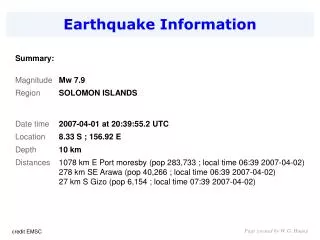
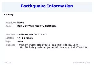
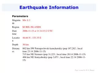
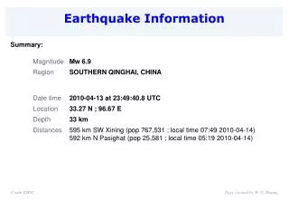
Earthquake Information European-Mediterranean Seismological Centre. Summary:. Credit EMSC. Page created by W. G. Huang. Taiwan. Credit EMSC. Page created by W. G. Huang. Page created by W. G. Huang. 全球的岩石圈之主要大板塊 MAJOR TECTONIC PLATES OF THE WORLD. 歐亞板塊 Eurasian. 北美板塊 North American.

E N D
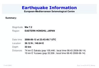
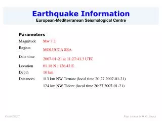
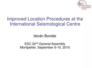
Earthquake Information European-Mediterranean Seismological Centre Summary: Credit EMSC Page created by W. G. Huang
Taiwan Credit EMSC Page created by W. G. Huang
全球的岩石圈之主要大板塊 MAJOR TECTONIC PLATES OF THE WORLD 歐亞板塊 Eurasian 北美板塊 North American 加勒比海板塊 Caribbean 菲律賓板塊 Philippines 太平洋板塊 Pacific 太平洋板塊 Pacific 非洲板塊 African 20070815’s quake 印度-澳洲板塊 Indian/Australian 南美板塊 South American 南極板塊 Antarctica 納薩卡板塊 Nazca Peru, like much of the west coast of North and South America, lies above an area of intense seismic activity and is no stranger to earthquakes. The nearby Nazca tectonic plate, which lies under the Pacific Ocean, is forced underneath the South American continental plate at a rate of about 4 cm a year. That may not sound a lot but it is enough to put huge strain on the earth's crust. The pressures are periodically released through earthquakes. Page created by W. G. Huang
Rory Carroll, Latin America correspondentFriday August 17, 2007The Guardian Peruvian rescue services were combing through rubble last night for survivors of a powerful earthquake which killed at least 450 people and injured more than 1,500. Several villages and towns south of the capital, Lima, were in ruins, with dozens of bodies scattered on the streets and hundreds more feared to be lying beneath collapsed buildings. The 8.0-magnitude quake struck at 6.40pm local time on Wednesday and lasted for several minutes. Power blackouts, cracked motorways and boulders tumbling from mountains blocked the Pan-American highway and delayed rescuers reaching the worst-hit areas. 'The earth was like jelly' - hundreds die in Peru quake, but Lima escapes Scientists said the quake was a "megathrust" - the largest of earthquakes - similar to the Indian Ocean temblor in 2004 that generated a deadly tsunami. At least 200 people in the town of Pisco were reported trapped under a church which caved in during a service. "So much effort and our city is destroyed," the town's mayor, Mendoza Uribe, told local radio. About 70% of the port city of 60,000 people had been levelled, he said, weeping. "We don't have lights, water, communications. Most houses have fallen, churches, stores, hotels, everything is destroyed." Witnesses from the nearby town of Chincha said there were at least 30 bodies at the badly damaged hospital. With the weather being cold many of the homeless appealed for blankets. Damage to the city and province of Ica was "dramatic", according to the deputy health minister, José Calderón. The government declared a state of emergency in the affected areas, appealed for blood donations and mobilised thousands of police, soldiers and medical staff. It promised an "air bridge" to shuttle the most badly injured to Lima. Hospital doctors called off a planned strike. Telephone companies appealed to people to make emergency calls only. A quarter of Ica's buildings were said to have collapsed and several churches were badly damaged, with local media reporting that in one church falling masonry killed 17 worshippers. At least 57 bodies were brought to the morgue, and injured people crowded into a hospital which resembled a war zone, with blood on the floor, screaming children and overwhelmed medical staff, according to reports. Rory Carroll, Latin America correspondentFriday August 17, 2007 Page created by W. G. Huang
Yesterday, Peru's national disaster management authority estimated at least 450 were dead and 1,500 injured. The Red Cross said the toll was expected to rise. However the doomsday scenario did not happen: Lima, a vast metropolis of poorly built concrete which has suffered cataclysmic earthquakes in the past, shook violently but escaped with minor damage and only one recorded death. "It made waves and the earth was like jelly," Antony Falconi, 27, told the Associated Press. "Who isn't going to be frightened? The Earth moved differently this time." Another Lima resident, María Pilar Mena, 47, said it was the strongest tremor she had ever felt. "When the quake struck, I thought it would never end." The US Geological Survey said the epicentre was beneath the Pacific coast about 90 miles south-east of the capital. Four strong aftershocks ranging from 5.4 to 5.9 followed, the organisation said. In 1970 a 7.9-magnitude earthquake in the Andes north of Lima triggered a landslide which buried the town of Yungay, killing up to 66,000 people. Many people were forced to spend the night in local parks. Photograph: Karel Navarro/AP Rory Carroll, Latin America correspondentFriday August 17, 2007 Page created by W. G. Huang
Research animations of the August 15, 2007 Peru tsunami propagation created with experimental runs of the MOST tsunami forecast model and including DART™ buoy data. Yellow squares indicate DART™ buoy locations. Click the image to animate (left) or enlarge (right). The animation and graphic display qualitative and quantitative information about the tsunami propagation including tsunami wave interaction with ocean floor bathymetric features, and neighboring coastlines. The tsunami radiation pattern is indicated with color coded information about the maximum wave amplitude at different locations throughout the Pacific Ocean. The timer and moving yellow squares indicate time elapsed since time of the earthquake, providing an estimate of tsunami arrival time at different locations (left). credit NOAA / PMEL / Center for Tsunami Research Page created by W. G. Huang
Peru Earthquake (8/15/2007) Animation of the tsunami propagation over the Pacific Ocean. USC modeled the first 2 hours of the tsunami waves showing an energy distribution with a predominantly SSW orientation. Maximum wave height distribution 10 hours after the earthquake in the vicinity of Peru. Credit Tsunami Research Center, University of Southern California Page created by W. G. Huang
The particle velocities recorded at 101B (near Taipei 101) with a depth of 100 meters EW NS V Page created by W. G. Huang 10 min.