Download
1 / 16
160 likes | 268 Views
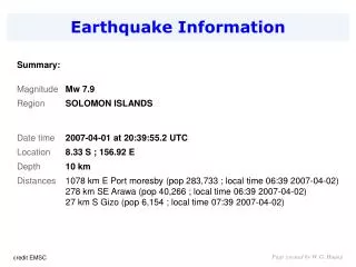
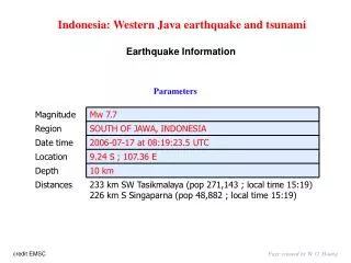
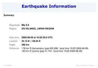
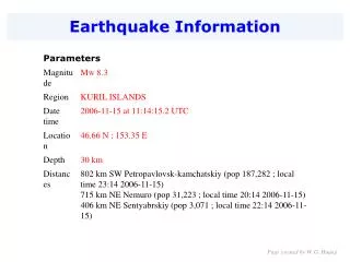
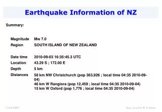
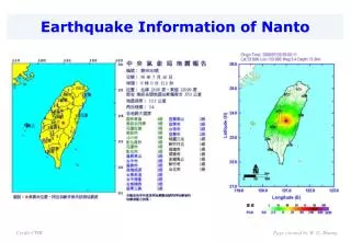
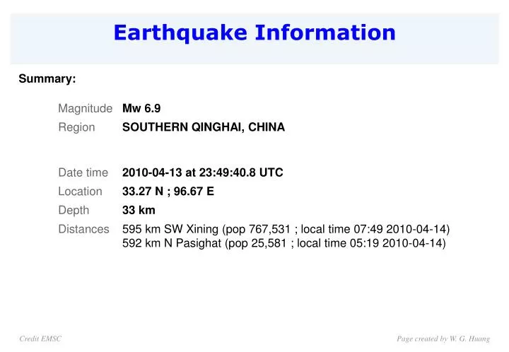
Earthquake Information. Summary:. Credit EMSC. Page created by W. G. Huang. Earthquake Parameters. 200805120627 Mw=7.9, D=10 km. 201004132349 Mw=6.8, D=33 km. Page created by W. G. Huang. 歴史地震. Credit ERI. Page created by W. G. Huang.

E N D
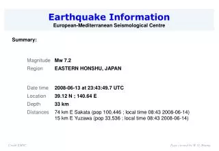
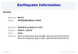
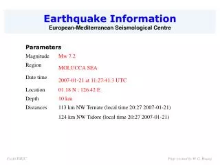
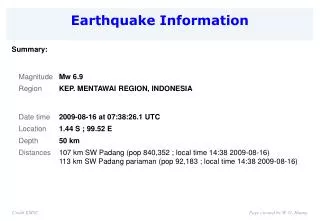
Earthquake Information Summary: Credit EMSC Page created by W. G. Huang
Earthquake Parameters 200805120627 Mw=7.9, D=10 km 201004132349 Mw=6.8, D=33 km Page created by W. G. Huang
歴史地震 Credit ERI Page created by W. G. Huang
A magnitude 6.9 earthquake struck the Tibetan Plateau in southern Qinghai Province, China, on April 13, 2010, killing hundreds of people and injuring as many as 10,000. As the India Plate pushes north, the eastern side of the Tibetan Plateau is getting bent and stretched toward the south-southeast. According to the U.S. Geological Survey, the quake occurred along a strike-slip fault, and it was one of the largest known earthquakes to have occurred within several hundred kilometers of the location. Based on data collected by the Shuttle Radar Topography Mission in 2002, this map shows the location of the quake and several aftershocks (black circles) as well as significant tectonic faults (red lines). A northwest-southeast valley provides evidence of the underlying geologic fault. The dotted line to the southwest traces the approximate location of a suture zone, which, as its name suggests, is an area where two continental plates have joined together. Credit NASA Page created by W. G. Huang
Yushu, China Earthquake Image Collected April 15, 2010 Credit: Digital Globe Page created by W. G. Huang
Credit: Digital Globe Page created by W. G. Huang
Credit: Digital Globe Page created by W. G. Huang
Credit: Digital Globe Page created by W. G. Huang
Credit: Digital Globe Credit: Digital Globe Page created by W. G. Huang Page created by W. G. Huang
Credit: Digital Globe Credit: Digital Globe Page created by W. G. Huang Page created by W. G. Huang
Credit: Digital Globe Credit: Digital Globe Page created by W. G. Huang Page created by W. G. Huang
Credit: Digital Globe Credit: Digital Globe Page created by W. G. Huang Page created by W. G. Huang
Rescuers and survivors work to dig people out A small part of the destruction in Yushu county, Qinghai province Photograph: ChinaFotoPress/Getty Images Page created by W. G. Huang
A man stands in rubble of a destroyed building in Jiegu town A car amongst under the ruins and debris Photograph: Wu Hong/AP Page created by W. G. Huang
A destroyed building in Jiegu town Collapsed houses in the Tibetan Autonomous Prefecture of Yushu, Qinghai province Photograph: Wu Hong/AP Page created by W. G. Huang