Download
1 / 1
10 likes | 124 Views
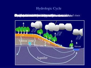
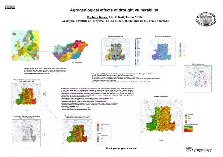
Surface geological map. Level of the groundwater. The searched area. Late Holocene. Early Holocene. Late Pleistocene. Drought-vulnerability. the smallest small medium high the highest. Depth and thickness of the uppermost impermeable layer under the surface.

E N D
Surface geological map Level of the groundwater The searched area Late Holocene Early Holocene Late Pleistocene Drought-vulnerability the smallest small medium high the highest Depth and thickness of the uppermost impermeable layer under the surface Thickness of the uppermost impermeable layer under the surface Depth impermeable on the surface Depth of the impermeable layer no impermeable layer 0-1 m 1-2 m 2-4 m > 4 m Thickness Depth of the groundwater no impermeable layer Agrogeological effects of drought vulnerability Barbara Kerék, László Kuti,Tamás Müller Geological Institute of Hungary, H-1143 Budapest, Stefánia út 14., kerek@mafi.hu Salt effected areas Drought means such lack of water in a given area, when the precipitation and the water sources are not enough to satisfy the demand. The harmful effects of drought depend on the sensibility and vulnerability of the area. In Kreybig L.’s (1938) opinion, the effects playing role in the development of drought are the follows: „1. lack of precipitation and the unfavourable distribution of that, 2. the different water management capabilities of the different soil types, 3. inefficient cultivation and fertilization methods without the water- and nutrient managements of the soil taken into consideration, and finally 4. producer systems not suitable for the water management attributes of soils and plants.” The depth of the uppermost impermeable layer under the surface Based on our observations, in spring and in summer the lack of precipitation does not mean the lack of moisture in the given area, and the precipitation surplus in winter and spring does not means avoiding drought. Precipitation could be stored, drained or evaporated depending on the geological buildup of the area. So to establish the drought vulnerability of an area, it is necessary to know, that whether it can receive and store the precipitation for a shorter or longer period and how much it could be. It follows that, these geological (agrogeological) factors should be searched: 1. permeability and impermeability of the formations above the groundwater level, 2. water raising capacity of the formations above the groundwater level, 3. water storing capacity of the formations above the groundwater level, 4. clay content and clay mineral spectrum of the formations above the groundwater level, 5. presence of salt affected formations and the tendency to salinization of the formations above the groundwater level, 6. depth of the groundwater above sea level, 7. speed and direction of the groundwater flow. impermeable on the surface 0-2 m 2-4 m 4-10 m > 10 m Agrogeology Thank you for your attention!