Download
1 / 50
510 likes | 606 Views
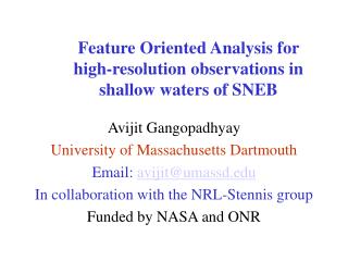
Feature Oriented Analysis for high-resolution observations in shallow waters of SNEB. Avijit Gangopadhyay University of Massachusetts Dartmouth Email: avijit@umassd.edu In collaboration with the NRL-Stennis group Funded by NASA and ONR. OUTLINE. Feature Oriented Regional Modeling

E N D
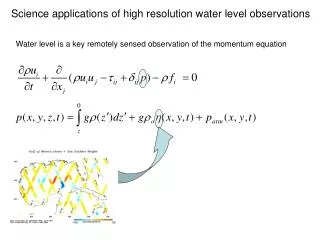
Feature Oriented Analysis for high-resolution observations in shallow waters of SNEB Avijit Gangopadhyay University of Massachusetts Dartmouth Email: avijit@umassd.edu In collaboration with the NRL-Stennis group Funded by NASA and ONR
OUTLINE • Feature Oriented Regional Modeling • Concept -- Initialization/Synthesis Methodology • Vertical Structure of Features via EOFs • Shallow water applications – MODIS • Feature oriented data synthesis…..
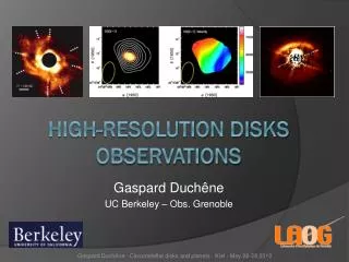
Gulf Stream Warm Core Rings Cold Core Rings Southern Recirculation Gyre Northern Recirculation Gyre Deep Western Boundary Current Gangopadhyay et al., 3-part series in 1997: Journal of Atmospheric and Oceanic Tech. (14) 1314:1365 Maine Coastal Current NEC Inflow GSC Outflow Jordan Basin Gyre Wilkinson Basin Gyre Georges Basin Gyre Georges Bank Gyre Tidal Mixing Front Gangopadhyay et al. 2002 (Continental Shelf Res. In Press) Gangopadhyay and Robinson, 2002: DAO 36(2002) 201-232 Features in Western North Atlantic Deep Sea region (GSMR) Coastal region (GOMGB)
U(x,y,z)=(y){[UT(x)-UB(x)](x,z) + UB(x)} T(x,y,z)=Ta(x,z)+(x,z)(y) where, Ta(x,z)={[T0(x)-Tb(x)](x,z) +Tb}
=tan Where, m is the melding function:
In general, a coastal current (CC), a front (SSF) and an eddy/gyre (E/G) are represented by: CC: TM(x, η, z) =TMa(x, z)+ αM(x, z) M(η) SSF: Tss(x, y, z) = Tsh (x, z) + (Tsl (x, z) – Tsh(x, z)) (, z) E/G T(r, z) = Tc (z) - [Tc (z) - Tk (z) ] {1-exp(-r/R)} where, TMa(x, z), Tsh (x, z) and Tc (z) are axis, shelf and core (η) = (0 W) (, z) = ½ + ½ tanh[(-.Z)/]
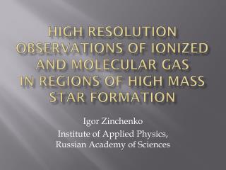
Strategy for GOMGB MCC WBG JBG GBG GBAG TMF SSF Inflow/Outflow
FORMS Protocol • Identify Circulation and Water mass features • Regional Synthesis -- Processes from a modeling perspective • Synoptic Data sets -- in-situ and satellite • Regional Climatology (Background Circulation) • OA (Climatology + Feature Models) • Simulation -- Nowcasting/Forecasting
FORMS Applications in Different Oceans • Western north Atlantic – Operational modeling in GOMGB – AFMIS-RFAC • Strait of Sicily – Dynamical analysis • Monterey Bay real-time forecasting with ROMS – AOSN-II in summer 2003 -- Upwelling • Brazil Current Meander-eddy-Upwelling System • Persian Gulf, Arabian Sea – Rapid response • Chilean Waters – Northern Humboldt Current – Biophysical modeling
Feature oriented methodology is applicable to ALL different Numerical Models • MOM (Modular Ocean Model) • POP (Parallel Ocean Program) • ROMS (Regional Ocean Model System) • POM (Princeton Ocean Model) • MIT GCM • HOPS (Harvard Ocean Prediction System) • Finite Element / Finite Volume models It is an Initialization and Assimilation Methodology
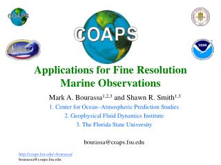
Southern California Coastal region
The Hardest Work of All!! SEC IWBC
OBJECTIVELY BASED FEATURE MODEL • Wilkinson basin water masses • Brooks June 1982 data • Cluster model of water masses • EOF vertical analysis • Feature model of vertical temperature and salinity
CLUSTER MODEL Distance function where
Explained Percent Variance No. of Modes Included
The 1997 PRIMER IV Field experiment To-be-analyzed via Cluster-EOF analysis with NRL-Stennis team
Shallow water feature models • Use of ‘intelligent observations’ that are important to resolve the scales and represent the underlying dynamical processes • Not only temperature-salinity structure, but include first-order dynamics • Process-oriented feature models
Upwelling • Wind speed and direction at highest available resolution from QuikScat • Mixed-layer depth estimate from MODIS • Infer the Ekman Current in the Upper Mixed layer • Additional baroclinic currents may be added for coastally trapped waves or alongshore currents • Monterey Bay in Summer 2003,Vietnamese shelf in summer 2003, Brazil Current - Cape Frio upwelling region in austral summer 2003.
Transient feature models • Coastal filaments, jets, squirts and eddies • Automated gradient-detection algorithm (Cayula and Cornillon, 1995) • Small scales (1-100 km) and short-life (20-40 days) • Spatial and temporal dependence of FM parameters • Low vs. high chlorophyll regions (Chan, 1999)
Feature tracking in shallow coastal regions • MODIS instrument on Terra and Aqua • Resolution ~ 250 meters (1-km globally) • Temperature precision – 0.3-0.5K • Navigational accuracy – 50 meters per pixel • Moving mesh algorithm (Rowley and Ginis, 1999) ; Wavelet approach (Liu et al., 2002) • Monterey Bay application – SNEB?
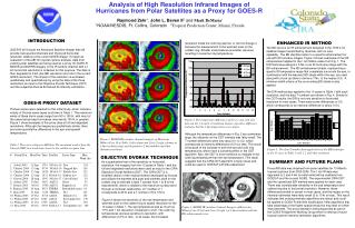
MODIS chlorophyll on July 23, 2002 for southern California from Terra (left) at 1815 GMT, and the same field from Aqua (right) at 2115 GMT. A feature-tracking algorithm that uses the chlorophyll field as tracer will deduce the surface currents, which can be assimilated in the Navy’s modeling system. [Courtesy:Ron Vogel, http://www.modis-ocean.gsfc.nasa.gov/whatsnew.html]
Application to CODAR • Pair of HF radars for measuring surface currents in our coastal regions • Virtually continuous surface currents at ~1km resolution over tens of kilometers • Tides, Baroclinic components, barotopic component, wind-driven component • Vertical Projection Method (Shen and Evans, 2001) obtains subsurface current structure within the Ekman Layer from CODAR and wind obs. – Extend this method to include baroclinic structure – with NRL-DC • Assimilation in parts in a dynamical model – POM in GOMOOS and ROMS-3Dvar in Monterey Bay
CONCLUSIONS • Synthesis of Multi-sensor observational system: Satellite (SST, SSH, SSC), in-situ, CODAR -- using feature-oriented approach • Feature Tracking -- High resolution data fusion (X-Band) 0.25 km MODIS data assimilation • EOF analysis for Vertical Structure determination
Reconstructed mean temperature Number of Modes
Error of reconstructed mean temperature Depth (m)
EOS-Terra Future Missions – NASA/NOAA/DoD sponsored FY 99 00 01 02 03 04 05 06 07 08 09 10 11 12 13 14 15 16 17 18 0530 DMSP DMSP-II NPOESS Windsat/Coriolis DMSP DMSP-II 0730-1030 POES METOP NPP 1330 POES NPOESS POES EOS-Aqua
EOS – Aqua • http://aqua.gsfc.nasa.gov/
MODIS - Moderate-resolution Imaging Spectroradiometer Characteristics • Channels: 36 (visible, near-, and thermal-infrared) • Resolution: 2 @ 0.25km, 5 @ 0.5km, 29 @ 1.0km • Data Rate: 13.125mbps • Revisit: 2 Days • Swath: 1780km • Compare to NOAA-AVHRR • Channels: 5 (VIS,IR,WV) • Resolution: 1.1km • Data Rate: 680kbps • Revisit: 2 Days • Swath: 3000km (Double-click the image to animate)
Feature Oriented Data Synthesis • Satellite Oceanography is here and more coming!! • Multiple Satellites -- multiple variables are being sensed for the same piece of ocean simultaneously!! • SST, SSH, SSC -- SSS coming soon! • High Resolution data in coastal regions -- MODIS, Aqua, Oceansat, FY-1