Download
1 / 13
130 likes | 208 Views
Process. Mapped and documented current conditions and trail use patterns Community outreach Seven initial public meetings were held at locations near each of the river segments These meeting included outreach to “user groups”

E N D
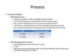
Process • Mapped and documented current conditions and trail use patterns • Community outreach • Seven initial public meetings were held at locations near each of the river segments • These meeting included outreach to “user groups” • Included feedback from the public via questionnaires, email and website. • Staff and technical review • Planning team has developed over 90 projects for review based on above input • Returned to the public for three additional public meetings regarding updates and additional public comment
What we heard from the public…summarized • Trail extensions and improved neighborhood linkages • Include better linkages to park system • Signage & Information • Direction and access to the greenbelt system • Maps and regulatory information (trail etiquette) about greenbelt system • Trail user information • Mile markers, bridge markers, You Are Here
What we heard from the public…summarized • Greenbelt amenities- additional trash receptacles (including pet waste), trail striping, water fountains • Conservation/ Preservation – greenbelt preserved, more trees, wildlife, pollution control • Trail design – widening trails in certain areas and correcting safety concerns, safe pedestrian crossings at major intersections, orientation of new development along the river, more separate running/ biking trails along the greenbelt • Raise public awareness – increased communication and education
Updates Trail Users on events, trail detours and construction • Lets users know what amenities are where • Now available for Androids!!