Download
1 / 11
110 likes | 126 Views
Texas Eco-regions. Effects of Weathering, Erosion and Deposition. Factors Affecting Our Ecoregions. Weathering – chemical and physical break down of rocks into sediment Erosion – the movement of sediment from one place to another

E N D
Texas Eco-regions Effects of Weathering, Erosion and Deposition
Factors Affecting Our Ecoregions Weathering– chemical and physical break down of rocks into sediment Erosion – the movement of sediment from one place to another Deposition – the placement of sediment after being carried from place of origin
CHEMICAL WEATHERING • THE PROCESS THAT BREAKS DOWN ROCKS BY CHEMICAL CHANGES OR REACTIONS.
MECHANICAL WEATHERING • THE PROCESS THAT BREAKS • DOWN ROCK PHYSICALLY.
EROSION • WHEN PIECES OF ROCK OR SEDIMENT ARE CARRIED AWAY BY WIND, WATER, ICE, OR GRAVITY.
DEPOSITION • WHEN SAND, SEDIMENT, AND ROCK ARE DROPPED OFF • IN A NEW LOCATION WHEN THE AGENT CARRYING • IT LOSES ENERGY AND DEPOSITS IT.
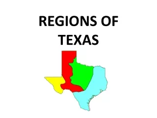
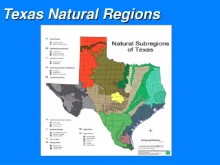
i. Piney Woods • This eco-region is found in Northeast Texas. • It is the wettest region of the state. This allows for a high rate of decomposition to occur resulting in healthy, nutrient-rich soils. • The topography is gently rolling to near flat through out the region. • Pine trees, woody vines, and hardwood trees dominate the vegetation • Unless an area has been clear-cut of vegetation for construction, the amount of trees and plants can prevent erosion by anchoring the soil.
ii. Gulf Coastal Prairies & Marshes • Found in Southeast Texas, near the coast. • Soil in the region is primarily sand-based. • Without adequate vegetation, rainfall received can cause severe erosion. • Catastrophic events such as hurricanes can increase wave erosion anddeposition.
iii. Edwards Plateau • This region is located in Central Texas between dry western plains and moist prairies and woods. • Unfortunately, excessiveerosionhas left most of the region with very shallow soils (less than 10 inches) lined with limestone rock layers. • High amounts of rain in a short amount of time can cause flash flooding.
iv. High Plains • “Texas Panhandle” • Largest and most completely flat areas of its size in the world! • The region extends to the Palo Duro Canyon-the nation’s 2nd largest canyon. • Palo Duro Canyon was formed by water erosion from the Prairie Dog Town Fork of the Red River. • The water deepens the canyon by moving sediment downstream. • Wind and water erosion continue to gradually widen the canyon.
v. Trans-Pecos 1.“Desert portion” of far West Texas. 2. Rain does not fall evenly over the area. 3. As a result of little rain and little vegetation, a lot of erosion and deposition is common in the area. 4. Soils in the canyon bottoms and valleys are deeper as a result of deposition.