Download
1 / 39
420 likes | 990 Views
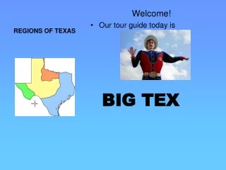
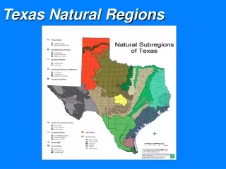
TEXAS REGIONS. What are the Regions of Texas?. The regions of Texas are…. Gulf Coastal Plain High Plains Central Plains Mountains and Basins. Welcome to the Mountains and Basins!!. Location. Far west Texas East border near Pecos River South border is the Rio Grande

E N D
The regions of Texas are… Gulf Coastal Plain High Plains Central Plains Mountains and Basins
Location • Far west Texas • East border near Pecos River • South border is the Rio Grande • North border is New Mexico
Landforms/Geographic Features • Mountain Ranges: Chisos Mountains, Davis Mountains, Guadalupe Mountains • Guadalupe Peak • Plateaus • Basins • Desert • Pecos River • Rio Grande River
Climate • Driest part of state • 8 inches of rain per year in the basins • 20 inches of rain per year in the mountains • Hot days, cool nights
Plants Chollo Cactus Mesquite Sagebrush
Animals Javelina Roadrunner Grey-banded King Snake Lizard Scorpion Horned Toad Rattlesnake Armadillo Coyote
Economics • Ranching - cattle, sheep, goat • Farming - cotton, fruits, vegetables, cantaloupes (irrigation in El Paso and Pecos River Valley) • Oil and gas - part of Permian Basin
Cities • El Paso • Fort Stockton • Pecos • Presidio • Van Horn
STOP……………. • Our next region we will look at is….. High Plains
Location of High Plains • Northeast Texas • Colorado and Red Rivers are the borders.
Landforms/Geographic Features • Caprock Escarpment • Edwards Plateau • Stockton Plateau • Palo Duro Canyon • Rolling grassy lands • Thick grasses • Cross Timbers area • Limestone rock • Numerous rivers • Elevation 1,640 feet – 4,920 feet
Climate • Coolest temperatures in Texas • 12 – 36 inches of rain per year • Tornadoes • Dry air
Plants • Grass • Cotton • Wheat • Wildflowers • Prickly pear • Yucca • Indian Paintbrush • Cedar Trees
Animals • Mountain Lion • Roadrunner • Prairie Dog • Jackrabbit • Burrowing Owl • Pronghorn • Snakes • Armadillo • Coyote
Economics • Ranching - cattle, angora goats (mohair) • Farming – cotton, fruits, vegetables, watermelons, oats • Oil and gas
High Plains Cities • Amarillo • Lubbock • Midland • Odessa
STOP……………. • Our next region we will look at is….. CENTRAL PLAINS
Location of Central Plains • Bordered on the north by the Red River • Bordered on the west by the Caprock Escarpment • The Colorado River runs through the southern edge of the Central Plains
Landforms of Central Plains • Caprock Escarpment • Red River • Brazos River • Colorado River
Climate • 12 – 36 inches of rain per year • Tornadoes • Dry air
Plants • Grass • Cotton • Wheat • Prickly Pear Cactus • Texas Oak Trees • Mesquite Trees • Bald Cypress Trees
Animals • Bald Eagle • Armadillo • Horned Lizard • Bobcat • White-tailed deer • Screech Owl
Economics Ranching – dairy cattle Farming – cotton and grains Oil and gas Coal
Cities • Wichita Falls • Abilene • Killeen • Burnet • Ft. Worth
Location of Coastal Region • Covers 1/3 of the land of Texas • Northern border is Oklahoma and Arkansas • Eastern border is the states of Louisiana and Arkansas • Southeast border is the Gulf of Mexico • Southwest border is the Rio Grande River • West border is the Balcones Escarpment
Landforms….. • Hill Country - an area of hills along the Balcones Fault and is a transitional area between the High Plains and the Gulf Coastal Plains • Balcones Escarpment • Numerous rivers including: Sabine River, Neches River, Trinity River, Brazos River, Colorado River, Guadalupe River, San Antonio River, Nueces River, and Rio Grande River • Gulf of Mexico • Elevation: 0 feet – 1,640 feet
Climate……. • Hot and humid • 12 – more than 48 inches of rain per year • Tornadoes • Hurricanes
Plants • Numerous trees including : pine, oak, maple, and ash. • Tall grasses • Wildflowers • Holly • Red Mulberry • Red Chokecherry • Water Lily • Cattails
Bluebonnets Indian Blanket Standing Cypress Blue Sage
Animals…. • Hundreds of birds including: quail, hawks, owls, and bald eagles • Fresh water fish including: catfish, trout, and bass • Sea life found in the Gulf of Mexico: oysters, crab, shrimp, dolphins, sharks • White tail deer • Armadillos • Foxes • Beaver • Skunks • River otters • Bobcats • Alligators in the marshes!!! Some weigh up to 500 lbs!!! River Otters Alligator
Economics • Farming – oranges, grapefruit, vegetables, cotton, grain • Ranching – cattle • Fishing – fish and shrimp • Oil and gas • Shipping
Cities • Texarkana • Dallas • Waco • Austin • San Antonio • Corpus Christi • Houston • Galveston • Laredo • Brownsville