Download
1 / 49
490 likes | 798 Views
Texas Regions Powerpoint. Keese 2008. A little helpful hint…. Make sure you pay EXTRA CLOSE attention (who knows maybe even take a few notes) After every day that we look at the power point there will be a QUIZ and it WILL be for a GRADE!!! . Can you name the Regions of Texas?.

E N D
Texas Regions Powerpoint Keese 2008
A little helpful hint….. • Make sure you pay EXTRA CLOSE attention (who knows maybe even take a few notes) After every day that we look at the power point there will be a QUIZ and it WILL be for a GRADE!!!
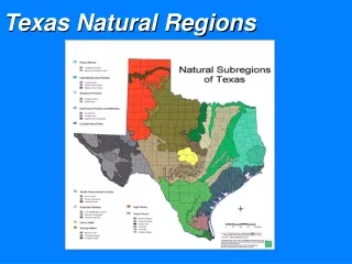
The regions of Texas are… Gulf Coastal Plain Central Plains High Plains Mountains and Basins
Location of Coastal Region • Covers 1/3 of the land of Texas • Northeast border is the Sabine River • Southeast border is the Gulf of Mexico • West border is the Balcones Escarpment
Coastal Climate……. • Hot and damp, humid • Tornadoes, hurricanes • 30-55 inches of rain per year
Coastal Cities…… • Austin • Houston • Dallas (on the border of Central Plains) • San Antonio • Texarkana • Corpus Christi • Brownsville
Way of life…. • The gulf coast is a major center of economic activity. The marshlands provide breeding grounds for ocean life, which make the fish and shrimp businesses very important. • The port of Houston is one of the 10 busiest ports in the world.
OIL AND GAS….. • Along the coastal region you will find many oil rigs that are on-shore and off-shore…. • The ocean gives easy access to ship the oil and gas to where it needs to go..
Who is this…….. Hint……you probably hear his name on the tv or radio EVERYDAY!!
PLANTS • The land along the Gulf Coast is very near sea level. It is hard for water to drain off the land, since there is nowhere lower for the water to go. Much of the coast of Texas is made up of marshes----wetlands where a variety of tall grasses grow.
Coastal Animals…. • Many kinds of animals live in the coastal region… To name a few… • Quail • Hawks • Owls • Hundreds of other birds • Bald eagle • White tail deer • Foxes • Skunks • River otters • Bobcats • Alligators in the marshes!!! Some weigh up to 500 lbs!!!
The real road runner….. Can you name other coastal animals……
Landforms….. • Let’s look at our Texas map to see some landforms in the coastal region…..
STOP……………. • Our next region we will look at is….. CENTRAL PLAINS
Location of Central Plains • The Great Plains include the Llano Estacado, the Panhandle, Edwards Plateau, Toyah Basin and the Llano Uplift. • It is border on the east by the Caprock Escarpment in the panhandle and by the Balcones Fault to the southeast. Picture of Edwards Plateau
Central Plains Climate • Central Texas is shaped by its many rivers and hills. The climate is subtropical. • In a single year the region can receive up to 48 inches of rain, and flooding is common near rivers and in low lying areas.
Central Plain Cities….. • Austin • Waco • Fredericksburg • Llano • The Hill Country is a popular name for the area of hills along the Balcones Fault and is a transitional area between the Great Plains and the Gulf Coastal Plains.
In the summer, one of the favorite activities is floating down a creek or river in an inner tube. Spring is a time for residents to drive the winding back roads and take in the rainbow of colors produced by the blooming wildflowers, including Bluebonnets and Indian paintbrush. In the fall and winter, hunters visit in hopes of taking home a white-tailed deer. • Some of the favorite local cuisines are barbecue and a variation on traditional Mexican food affectionately referred to as Tex-Mex..
Central Plain - Plants • Blue bonnets • Indian Paintbrush • Texas Oak Trees • Mesquite Trees • Baldcypress Trees
Indian Blanket Standing Cypress Blue Sage
Central Plain - Animals • Bobcat • White-tailed deer • Turkeys • Screech Owl • Mexican Freetail Bat • Cliff Swallow
Landforms of Central Plains • Let’s look at our Texas map to see some landforms in the Central Plains region.
STOP……………. • Our next region we will look at is….. High Plains
High Plains Cities • Amarillo • Lubbock • Abilene • San Angelo • Wichita Falls
Location of High Plains • Northeast Texas • Colorado and Red Rivers are the borders. • Geographic Features • Rolling grassy lands • Thick grasses • Cross Timbers area - large areas of hardwood trees • Limestone rock • Higher elevation because limestone doesn't wear down easily
Climate • Dry air • Tornadoes • 20-30 inches of rain per year
Way of Life • Farming - fruits, vegetables, watermelons, oats • Ranching - cattle, angora goats (mohair) • Cedar trees - fenceposts • Oil and gas
Plants • Prickly pear • Yucca • Indian Paintbrush • Cactus
Animals • Pronghorn • Prarie Dog • Snakes • Horny Toad
Landforms of High Plains • Take a look at the map!!!
Location • Far west Texas • East border near Pecos River • South border is the Rio Grande • North border is New Mexico
Cities • El Paso • Pecos • Kermit & Monahans in Permian Basin area • Fort Davis, Marfa, & Alpine in Mountain area
Climate • Driest part of state • 8 inches of rain per year, 20 in mountains • Hot days, cool nights
Way of Life • Ranching - cattle, sheep, goat • Farming - cotton, fruits, vegetables, cantaloupes (irrigation in El Paso and Pecos River Valley) • Oil and gas - part of Permian Basin
Plants • IT IS FLAT!!!!! • Some sagebrush
Landforms • Let’s look at 0ur map!!!
And now…. • Let me introduce our Regions Group Project!!!
You will be given a region to work on AS A GROUP. • You will need to find a way to make sure that all topics are somehow shown on your poster. Designate certain people to do certain jobs. • *This project will be given 2 FULL class days to work on and can be worked on during any extra catch-up time throughout the day. • *Project is due Friday, Sept 5th at the beginning of the social studies period.
*The following are requirements for your poster : • Illustration of Texas • Illustration of your given region. • Climate • Major cities • Way of life • Contributions • Plants and animals • Landforms • Any other interesting info you find. • *This is a MAJOR GRADE!!! • *Each group member will have an opportunity to grade the other members by using the rubric for the project.