Download
1 / 4
40 likes | 233 Views
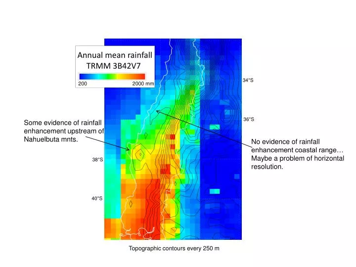
Annual mean rainfall TRMM 3B42V7. 34°S. 200 2000 mm. 36°S. Some evidence of rainfall enhancement upstream of Nahuelbuta mnts. No evidence of rainfall enhancement coastal range… Maybe a problem of horizontal resolution. 38°S. 40°S.

E N D
Annual mean rainfall TRMM 3B42V7 34°S 200 2000 mm 36°S Some evidence of rainfall enhancement upstream of Nahuelbuta mnts. No evidence of rainfall enhancement coastal range… Maybe a problem of horizontal resolution. 38°S 40°S Topographic contours every 250 m
Rainfall climatology of TRMM (1998-2011) compared with DGA data: Ok at subtropical locations but TRMM underestimate farther south DGA station elevation [m ASL] DGA (color) TRMM 3B42V7 (BW)
Actual daily values 5-day running mean TRMM 3B42V7 and DGA daily rainfall averaged in the region [71.5° 71°W; 35° 34°S]: TRMM “sees” most of the moderate rainfall events but often underestimate rain gauge value. Some problems due to temporal mismatch. Daily DGA records (mm) Daily DGA average Daily TRMM average Daily TRMM 3B42V7 (mm) Daily rainfall (mm) Days, 2003
Topografia TRMM climo Max sobre Cantillana? Problema con Nieve Artefacto cerca de 36°S