Download
1 / 26
260 likes | 427 Views
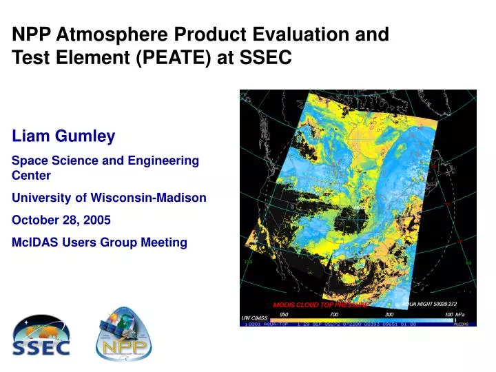
NPP Atmosphere Product Evaluation and Test Element (PEATE) at SSEC. Liam Gumley Space Science and Engineering Center University of Wisconsin-Madison October 28, 2005 McIDAS Users Group Meeting. Briefing Overview. NPP Mission and Science Goals Role of the Science Data Segment

E N D
NPP Atmosphere Product Evaluation and Test Element (PEATE) at SSEC Liam Gumley Space Science and Engineering Center University of Wisconsin-Madison October 28, 2005 McIDAS Users Group Meeting
Briefing Overview NPP Mission and Science Goals Role of the Science Data Segment Role of the Atmosphere PEATE SSEC activities in support of the PEATE
NPP is a joint partnership between NASA’s Science Mission Directorate and the NPOESS Integrated Program Office (IPO). Key program objectives: To provide NASA with continuation of global change observations initiated by the Earth Observing System (EOS) Terra, Aqua, and Aura missions. To provide the NPOESS operational community with risk reduction demonstration and validation for selected NPOESS instruments and algorithms, as well as the ground system. NPOESS Preparatory Project
The NPP Science Charter: “Continue the Scientific Data Record started by EOS”. “Measurement-based” instead of “Mission-based” data processing system. NPP is the first post-EOS mission to have this new science data processing strategy. NPP data products will be produced by NPOESS data processing system (IDPS) NPP data products will be archived by NOAA (CLASS/LTA). NPP data products will be assessed for science quality at the NASA Science Data Segment (SDS) by the NPP Science Team. NPP Science Goals and Strategy
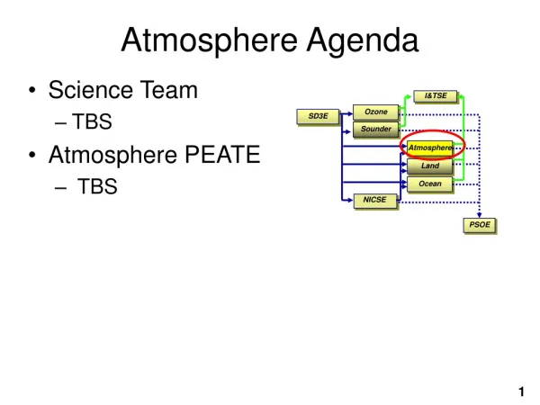
Space Segment NPP Direct Broadcast User Launch SupportSegment NPP System Architecture GPS TDRSS WSC LEO & A Backup T&C AFWA Central NESDIS Central Science Data Segment Land PEATE Command, Cntrl & CommSegment I/F Data Proc Segment Ocean PEATE SD3E Data Del Data Del Ozone PEATE GSE - Svalbard Primary T&C NPP SMD DQM I&TSE Process Process Infra Infra Atmos PEATE NICSE Data Mgt Data Mgt Ingest Ingest Sounder PEATE Archive & Dist Segment Ingest • Mission Mgmt Center - Suitland • Flight Operations Team • • Enterprise Management • • Mission Management • • Satellite Operations • • Data Monitoring & Recovery Archive Interchange Datastore Data Handling Node Inventory RoboticStorage Archiver Data Routing & Retrieval NPP Mission Data Command and Telemetry Key: Climate User Community MSO - 4
NPOESS Preparatory Project (NPP) April 2008 launch (subject to change) 824 Km Sun Synchronous Orbit with 10:30 descending orbit 16 day ground-track repeat similar to Landsat, Terra, Aqua, Aura Science Instruments: Visible Infrared Imager Radiometer Suite (VIIRS) Cross-Track Infrared Sounder (CrIS) Advanced Technology Microwave Sounder (ATMS) Ozone Mapping & Profiling Sensor (OMPS) Direct Broadcast of all data (X-Band) NPOESS 1st Launch ~ 2011 into 833 Km orbit with 17:30 crossing time Subsequent launches into 13:30 and 21:30 ascending orbits Replacement satellites will be launched on failure of VIIRS Continues into the indefinite future Continuous Direct Broadcast of all data (X-Band) Low Rate Data (LRD) broadcast on L-Band; lossy compression NPP Mission Summary
NPP Deliverables are Products Raw Data Records (RDRs) • Similar to Level 1A for CEOS/NASA • ~ 150 giga bytes per day (similar to Terra or Aqua) Sensor Data Records (SDRs) • Similar to CEOS/NASA Level 1B Environmental Data Records (EDRs) • Similar to CEOS/NASA Level 2 • NPP Provides 25 of 55 NPOESS EDRs 12 Mbps 3 Mbps APS CMIS VIIRS SESS/ AURORA ERBS TSIS ALT CrIS/ATMS OMPS Fly on NPP Fly on NPOESS
VIIRS: Continuous Cross-track scanner 22 spectral bands VisNIR, DNB, SWMIR, LWIR Heritage from MODIS on EOS Terra/Aqua Supplier: Santa Barbara Remote Sensing (Raytheon) Key Subcontractors (NPOESS): Rotating Telescope - AXSYS FPA’s, Raytheon Vision Systems Scan motor/encoder -BEI VIIRS Engineering Development Unit (EDU) is now in test VIIRS FU1 is being developed for NPP VIIRS (Imager)
EDRs Imagery Sea Surface Temperature Soil Moisture Aerosols (3) Cloud Properties (7) Surface Albedo Land Surface Temperature Vegetation Index Snow Cover Land Surface Type Active Fires Ice Surface Temperature Net Heat Flux Ocean Color/Chlorophyll Sea Ice Characterization VIIRS Products • VIIRS measures Earth surface and atmospheric/cloud radiance • 21 of 22 VIIRS Bands are located in Atmospheric Windows Solar reflection region Thermal emission region RDRs EDR Algorithms SDRs (calibrated, geo-located radiance) SDRAlgorithms
The Cross-track Infrared Sounder (CrIS) is a key sensor Fourier Transform Spectrometer providing high resolution IR spectra: Fields of Regard each 3 x 3 FOVs Photovoltaic Detectors in all 3 bands 4-Stage Passive Detector Cooler 14 km nadir spatial resolution 2200 km swath width On-board internal calibration target Supplier: ITT Industries Key subcontractors: ABB Bomem, Interferometer, ICT & SDR algorithm DRS, detectors AER, EDR algorithm CrIS (Infrared Sounder)
22-channels (23.8 GHz – 183.3 GHz), functional-equivalent follow-on to AMSU-A and MHS, with improved sampling and coverage Total-power, two-point external calibration, self calibrated Continuous cross-track scanning, with torque & momentum compensation Four modes: Off/Survival, Safe Hold, Diagnostic, Operational Software upload capability; none required Built-in diagnostics capability In Operational Mode, operate continuously without additional commands Thermal control by spacecraft cold plate ATMS (Microwave Sounder)
Provides Ozone Total-Column and Profile measurements Enables calculations of corresponding EDR Comprises 3 subsystems Nadir Sensor, Limb Sensor, Main Electronic Boxes (MEB) Sensors use identical FPAs Nadir Sensor comprises 2 co-boresighted spectrometers: Nadir Total-Column (300 to 380 nm) Based on TOMS heritage 2800 km cross-track swath (110° FOV) Divided in 35 bins (50 km at nadir) Nadir Profile (250 to 310 nm) Based on SBUV2 heritage 250 km x 250 km cell OMPS (Ozone Profiler) • Limb Sensor measurements are made through 3 aft-viewing slits • 1.95* degrees FOV • 290 to 1000 nm spectral range • 1 km sampling interval • Boresight at ~ 27.3° from velocity vector to look at Earth limb
NASA Science Data Segment NPP Science Team CARS: Oceans NASA GSFC McClain, Charles Wang, Menghua Minnett, Peter Justice, Christopher Loveland, Thomas Lyapustin, Alexei Maslanik, James Privette, Jeffrey Ranson, Jon Schaaf, Crystal Vermote, Eric Wolfe, Robert Baum, Bryan Han, Qingyuan Menzel, Paul Stamnes, Knut Torres, Omar McPeters, Richard Pagano, Thomas Fishbein, Evan Revercomb, Henry Lambrigtsen, Bjorn Staelin, David Strow, Larrabee SDS Components Network Infrastructure NPP PEATE CARS: Land NASA GSFC NPP PEATE SD3 RDRs SDRs EDRs CARS: Atmosphere Univ. Wisconsin NOAA / CLASS NPP PEATE I/T System IPO / IDPS RDRs SDRs EDRs CARS: Ozone NASA GSFC NPP PEATE CARS: Sounder NASA JPL CARS: Climate Analysis Research System PEATE: Product Evaluation &Test Element NPP PEATE Project Science Office NICST
Pre Launch Acquire, adapt and integrate operational SDR and EDR processing software Perform functional testing of operational code. Acquire and manage various preflight instrument characterization data sets provide to ST. Support Interface Confidence Tests, Functional Thread Tests and NPP Compatibility Tests Support (as needed) generation of test data sets for software and algorithm testing. Post Launch Acquire all RDRS, selected SDRs, EDRs and ancillary data Process RDRs to SDRs and EDRs using operational code using alternative calibration LUTS Process SDRs to EDRs using revised or alternative algorithms, as directed by ST Support browse and distribution of locally generated xDRs to ST Perform matchups and evaluation of EDRs with other Mission Data, e.g., MODIS, SeaBASS SDR Evaluation for Long-term stability PEATE Role in SDS
Supports NPP Science Team evaluation of standard VIIRS RDR, SDR, and atmosphere EDRs Provides a testbed for improved EDR algorithms (VIIRS, CrIS, ATMS) Provides processing and visualization resources for NPP Science Team Serves as a building block for constructing in-house, long term, multi satellite climatology of cloud retrievals (funded by multiple agencies) Facilitates the development of product centric multi-mission satellite retrieval algorithms and software NPP Atmosphere PEATE at SSEC
Areas of Expertise and Partners • Key Areas of Expertise at SSEC • RDR, SDR, EDR software testing and product evaluation • Improved algorithm development • Data ingest, storage, catalogue, retrieval, visualization • Processing system architecture (clusters) • Real-time operations • Critical Partners in Atmosphere PEATE • NPP Science Team • Scientific programmers • Cal/Val partners • Direct Broadcast Community • Processing Systems Group • Data Center + IT support
Atmosphere PEATE Organization Project Management Hank Revercomb (PI) Liam Gumley (Co-I, PM) Products & Algorithms Bryan Baum (Lead) Andy Heidinger Chris Moeller Dave Tobin Rich Frey Kathy Strabala Suzanne Wetzel Eva Borbas Computing Systems Paolo Antonelli (Lead) Ray Garcia Steve Dutcher Erik Olson Dave Santek Tom Rink Maciek Smuga-Otto Operations Dee Wade (Lead) Jerry Robaidek Dave Parker Rosie Spangler Janean Hill
Obtain and evaluate candidate SDR and EDR codes and sample data (CasaNosa) Port candidate codes to Linux batch processing environment* Identify and ingest initial proxy data (e.g. MODIS, AIRS, IASI) Identify and acquire initial hardware (compute nodes, storage) Near Term Goals *in cooperation with other PEATES
Familiarization with Atmosphere ATBDs Review of SDR and EDR contents and metadata Obtain and evaluate (walkthrough) candidate SDR and EDR codes for VIIRS (e.g., calibration, cloud mask, cloud product) Identify proxy datasets for product comparison (e.g., POES AVHRR/HIRS, Aqua MODIS/AIRS, MetOp AVHRR/IASI) Identify pre-launch characterization and cal/val support activities Products and Algorithms
Identify near term hardware needs (computing, storage, networking) Procure and install new hardware Investigate strategies for running IDPS Sci and Ops code on Linux (with GSFC/DRL) Extend current parallel processing framework to work with OPS code Computing Systems
Computing System Baseline Existing Opteron Cluster (Rocks 3.3 64-bit) Head node: Sun V40z [4 x Opteron 2.2 GHz CPUs, 8 GB RAM, 6 x 73 GB disk] 8 compute nodes: Sun V20z [2 x Opteron 2.2 GHz CPUs, 2 GB RAM, 2 x 73 GB disk] Storage: 5.6 TB RAID [16 x 400 GB SATA disks, 2 Gbps Fibrechannel interface] Network: Gigabit Ethernet [Dell Powerconnect 24-port switch]
Atmosphere PEATE EDRs • NPOESS VIIRS EDRs, including • [All currently generated at UW from Direct Broadcast] • Atmospheric CDRs from the NPP Science Team that can be generated from NPP VIIRS or VIIRS/CrIS combined data sets • [Activities will be closely coordinated with NOAA & Sounder PEATE activities to maximize efficiency]
Atmosphere PEATE Work Plan • FY05 - Establish links with NPP Science Team - Familiarization with Science & Operational EDR Algorithms - Begin to Define System Architecture • FY06 - Support Science Team evaluation of NGST EDR algorithms & development of improved algorithms - Define System Architecture & implement Phase I PEATE System - Define Cal/Val support tasks & develop Cal/Val plan - Conduct initial proxy data processing experiments • FY07 - Continue to support Science Team algorithm evaluation & devel. - Complete System Hardware Acquisition and Testing - Demonstrate 30x processing on proxy data - Demonstrate System Readiness, including Science Team Interface • FY08 (Oct 2007 to Launch) - Continue to support Science Team algorithm evaluation & devel. - Complete third reprocessing of proxy dataset
Summary of PEATE activities • Run NGST science algorithms on proxy data: - FY06: 1 month each spring/summer/fall/winter from Terra/Aqua - FY07: complete mission record from Terra/Aqua • Run improved algorithms developed by NPP Science Team on these datasets • Provide the means to compare (at EDR and CDR level) the results of different algorithms • Provide online archive of proxy data and NPP data for Science Team search, order, and delivery