Download
1 / 1
20 likes | 190 Views
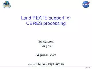
MODAPS ARCHIVE. Land PEATE Builds. VIIRS L1 Mod Res SDR. VIIRS L1 GEO SDR 750m. Algorithm Name. Build 1 04/2006. Build 2 10/2007. Build 3 12/2008. August 10, 2002 12:45GMT Namibia. Distribution Database Server. Production Database Server. VIIRS L1 Img Res SDR. Cloud Mask.

E N D
MODAPS ARCHIVE Land PEATE Builds VIIRS L1 Mod Res SDR VIIRS L1 GEO SDR 750m Algorithm Name Build 1 04/2006 Build 2 10/2007 Build 3 12/2008 August 10, 2002 12:45GMT Namibia Distribution Database Server Production Database Server VIIRS L1 Img Res SDR Cloud Mask Fire Mask NCEP GFS 750m Surface Type S O USGS 750m Granulation Ingest and Staging Servers Ethernet Switch Web and ftp servers MODAPS ARCHIVE Outside Network O Outside Network USGS GLCC 740m Land Surface Albedo S VIIRS L1 GEO SDR 750m NCEP Anc 1km Global Aerosol Optical Thickness Archive VIIRS Gridded IP 750m Aerosol Particle Size S O Land Cover Anc 1km Global VIIRS 750m Granulation SCIENCE All flags used to exclude elements from processing OPS All flags used to exclude elements from processing VIIRS Grid Snow/Ice Cover 1km NCEP 750m Granulation Cloud Mask Aerosol Suspended Matter S O O Land Surface Reflectance VIIRS Grid TOC NDVI VIIRS Grid Surface Types 750m Land Surface Reflectance VIIRS Gridded IP 375m S O O Fast Staging Disk Compute Servers Inexpensive Archive Disk 750m SCIENCE Only night flag used to exclude elements OPS Only night flag used to exclude elements SCI CODE 375m Land Surface Temperature Sea Ice Char./Ice Age Quality Vegetation Index S O O EVI and NDVI OPS V1.5 EXAMPLE: SURFACE REFLECTANCE OUTPUT OPS V1.4 Aerosol Optical Thickness Ice Surface Temperature 375m S O O NAAPS TOD 750m Ice Surface Temperature 750m O O NCEP Ancillary Data Profile Ice Concentration O O Daily Surface Reflectance Land Water Mask O O NOGAPS 750m Snow/Ice Cover O O VIIRS Previous Ice Age Geolocation O O Calibration NBAR NDVI O O Monthly CV MCV Gridding Cloud Optical Properties O 17-day Land Albedo Snow O O Land Surface Temperature Quarterly Surface Type O O O = Operational Code S = Science Code =use previous build Active Fires S, O Overview 1 2 Evaluating and Improving Products • The NPOESS Preparatory Project (NPP) VIIRS Land Product Evaluation and Algorithm Test Element (PEATE) supports the NPP Science Team in assessing the utility of NPP Land and Aerosol Environmental Data Records (EDRs) for climate research • Land PEATE builds upon the MODIS approach and infrastructure for science team support, product generation and quality assessment • VIIRS product generation software runs in MODAPS • Gridded (Level 3) products (Diagnostic Data Records) facilitate comparison with MODIS products and ground-truth • Products available online for Science Team evaluation • LDOPE (Land Data Operational Product Evaluation) team works with Science Team in evaluating product quality • This poster summarizes progress in developing the Land PEATE to support VIIRS product evaluation NPP VIIRS Land PEATE Ed Masuoka, Robert Wolfe, Alice Isaacman, Sadashiva Devadiga, Carol Davidson and Gang Ye NPP VIIRS Land PEATE NASA Goddard Space Flight Center, Code 614.5 3 4 OPS (Operational) software Adapting OPS code to run in MODAPS Land PEATE built upon MODAPS 5 • Runs in Interface and Data Processing Segment (IDPS) • Runs on IBM multi-processor servers under AIX • Written in C++ with most data transfers through memory • Archived products are written in HDF 5 • Software deliveries • Build 1.4 3/23/07 Preliminary algorithms with MODIS Collection 3 heritage • Build 1.5 10/30/07 update most algorithms to Coll. 4 / Coll. 5 MODIS plus fixes from chain testing • Build 1.5.x1 1/30/09 update remaining algorithms and LUTs • Build 1.5.x2 4/30/09 final updates to LUTs plus patches • Land PEATE uses MODAPS software for processing and distribution • Databases schedule, track and control jobs • Scalable clusters of inexpensive Intel-based servers running open source software (Linux, Apache, Perl) • Current small system runs VIIRS SCI and OPS software and Science Team updates to Land Surface Reflectance and Fire. Wrapper+Aggregator software enable: • OPS code to run in MODAPS [Wrapper] • All products to be read and written as HDF 4-EOS (MODIS format) 5 minute granules [Aggregator] Sources of Data Testing Improved Algorithms Documenting Q/A Issues 8 7 6 • Pre-Launch Test Data • Proxy data - MODIS Terra or Aqua L1B data mapped to nearest VIIRS band with mapping to VIIRS scan geometry. Produced by a revised SDRgen. • Proxy data – can be converted back to raw instrument packets and played back through the system to test SDR production software • Data from instrument testing • Post-Launch Data • VIIRS RDR, SDR, EDR, IPs from SD3E (primarily) and NSIPS and CLASS (occasionally) • MODIS products from MODAPS/LAADS for comparison with VIIRS SDR, EDRs and DDRs • Science Team may modify OPS code and/or LUTs or deliver entirely new science software • Modified software will run in a series of science tests producing EDRs and DDRs for comparison with MODIS products • LDOPE will perform visual and statistical evaluation of tests • Issues identified on a product by product basis are posted on Land PEATE Q/A web site at: http://landweb.nascom.nasa.gov/NPP • Each product quality issue is identified with a case number and is labeled as pending, closed or as note. • Detailed description on the issue can be obtained by clicking on the case number • If an issue has been fixed in a following algorithm version, the issue is labeled closed. • If an issue is related to problem in input data or an upstream algorithm then the issue is labeled as a Q/A note. • Developing HDF 5 to HDF 4 conversion tool to facilitate use of MODIS tools in VIIRS product analysis Algorithm Comparison Spring 2008 Processing Test Status 9 11 Algorithm Integration Schedule 10 Summary 12 • Land PEATE system runs both OPS code (operational software from IDPS Builds 1.4) and science algorithms updates from NPP Science Team members. • We will begin integrating Build 1.5 (at-launch) software in November 2007 and look forward to working with science team members in evaluating products produced by this software • LDOPE quality assessment team has posted “known issues” from chain testing of VIIRS production software on the VIIRS Land Q/A web site at: http://landweb.nascom.nasa.gov/NPP • MODIS Level 2g software is being adapted to produce VIIRS gridded data sets (DDRs) to use in comparisons with MODIS • LDOPE Q/A team has a prototype HDF 5 to HDF 4-EOS conversion tool to enable scientists to use tools developed for MODIS product analysis with VIIRS products from IDPS O