Download
1 / 33
330 likes | 467 Views
Observing, Analyzing, and Simulating the Boundary Layer in Northern Utah and Beyond. John Horel , Erik Crosman , Xia Dong, Matt Lammers , Neil Lareau , Dan Tyndall. Predictability in Complex Terrain. ~1990 Terrain more important than data

E N D
Observing, Analyzing, and Simulating the Boundary Layer in Northern Utah and Beyond John Horel, Erik Crosman, Xia Dong, Matt Lammers, Neil Lareau, Dan Tyndall
Predictability in Complex Terrain ~1990 Terrain more important than data But ”…the predictability enhancement by topography has been difficult to quantify” • Berri, Guillermo J., Jan Paegle, 1990: Sensitivity of Local Predictions to Initial Conditions. J. Appl. Meteor., 29, 256–267. • Paegle et al., 1990: Chapter 10. Atmospheric Processes over Complex Terrain. Now(?) • Topography may enhance predictability of certain flow types, but this has never been proven or refuted • Orography can exacerbate large-scale errors, reducing forecast utility Meyers and Steenburgh (2011). Mountain Weather Prediction: Phenomenological Challenges and Forecast Methodology. AMS Mountain Weather and Forecasting Monograph
Underlying research premise of Horel group during past 15 Years • Since operational forecast models can’t resolve the underlying terrain in sufficient detail to adequately resolve the details of boundary layer flows over complex terrain • Then knowing the initial state of the boundary layer over complex terrain is less critical for data assimilation than for: • Understanding the physical processes underway • Nowcasting • Forecast verification
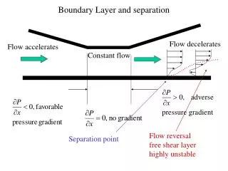
Flipping the question- from what’s the role of terrain to what’s the role of synoptic-scale systems: contribution to rising motion after reducing influence of local terrain Lareau and Horel (2011; in press MWR)
Coming soon… • 32 year ERA interim climatology of synoptic-scale ascent
Answering a simpler(?) question with idealized WRF LES: lake breeze Crosman, E. and J. Horel, 2012: Idealized Large-Eddy Simulations of Sea and Lake Breezes: Sensitivity to Lake Diameter, Heat Flux and Stability. Boundary Layer Meteorology. In press. Crosman, E., and J. Horel, 2010: Numerical sensitivity studies of sea and lake breezes: a review. Boundary Layer Meteorology. 137, 1-29.
Evolution in Resources/Capabilities • Utah Mesonet -> MesoWest • ADAS/ARPS -> RTMA -> UU2DVAR Matlab -> UU2DVAR Python • Core goals: • provide access to and integrate disparate observations • Use analyses to synthesize the observations for variety of applications • Forecast verification • Nowcasting • Network design (station additions AND REMOVAL) • Observation quality control
MesoWest/Local & National Surface Analysis Refs Tyndall, D. and J. Horel, 2012: Impacts of Heterogeneous Mesonet Observations on Meteorological Surface Analyses. To be submitted to WAF. de Pondeca, M., G. Manikin, G. DiMego, S. Benjamin, D. Parrish, R. Purser, W. Wu, J. Horel, D. Myrick, Y. Lin, R. Aune, D. Keyser, B. Colman, G. Mann, J. Vavra, 2011: The Real-Time Mesoscale Analysis at NOAA's National Centers for Environmental Prediction: Current status and development. Wea. Forecasting, 26, 593-612. Horel, John D., and X. Dong 2010: An evaluation of the distribution of Remote Automated Weather Stations (RAWS). Journal of Appl. Meteor. and Clim., 49, 1563-1578. Tyndall, D., J. Horel, and M. dePondeca, 2010: Sensitivity of surface air temperature analyses to background and observation errors. Wea. Forecasting, 25, 852-865 Myrick, D., and J. Horel, 2008: Sensitivity of surface analyses over the western United States to RAWS observations. Wea. Forecasting, 23, 145-158. Myrick, D., J. Horel, 2006: Verification over the Western United States of surface temperature forecasts from the National Digital Forecast Database. Wea. Forecasting, 21, 869-892. Horel, J., B. Colman, 2005: Meeting Summary: A community meeting on real-time and retrospective mesoscale objective analysis: An Analysis of Record summit. Bull. Amer. Meteor. Soc., 86, 1477–1480. Myrick, D., J. Horel, S. Lazarus, 2005: Local adjustment of the background error correlation for surface analyses over complex terrain. Wea. Forecasting, 20, 149-160. Lazarus, S., C. Ciliberti, J. Horel, K. Brewster, 2002: Near-real-time applications of a mesoscale analysis system to complex terrain. Wea. Forecasting, 17, 971-1000. Horel, J., T. Potter, L. Dunn, W. J. Steenburgh, M. Eubank, M. Splitt, and D. J. Onton, 2002: Weather support for the 2002 Winter Olympic and Paralympic Games. Bull. Amer.Meteor. Soc., 83, 227-240 Horel, J., M. Splitt, L. Dunn, J. Pechmann, B. White, C. Ciliberti, S. Lazarus, J. Slemmer, D. Zaff, J. Burks, 2002: MesoWest: Cooperative Mesonets in the Western United States. Bull. Amer. Meteor. Soc., 83, 211-226.
MesoWest currently provides 5,338 observational stations to MADIS from 80 different networks.
Integrating Mesonet Observations: Hourly T, TD, Wind CONUS Analyses 8 processors in ~20 minutes for CONUS
Issues we’ve spent a lot of time dealing with but are still a struggle • Specifying background and observation error covariances • Estimating representativeness errors • Impact of heterogeneous observations through data denial and adjoint sensitivity/impact studies • QC’ing observations manually and automated procedures
Tyndall and Horel (tbs WAF) • Given the heterogeneous equipment, maintenance and reporting practices, and siting of stations in mesonets, subjective decisions tend to be made to use some observations and avoid others • We determine objectively high impact surface T, Td, and Wind observations using the adjoint of a two-dimensional variational surface analysis over the contiguous United States • High impact observations are defined as arising from: • low observation quality, • observation representativeness errors, • or accurate observed weather conditions not evident in the background field • Impact of nearly 20,000 surface observations computed over a sample of 100 analysis hours during 25 major weather events. • Impacts are determined for each station as well as within broad network categories. • For individual analysis hours, high impact observations are located in regions of significant weather—typically, where the background field fails to define the local weather conditions. • Low impact observations tend to be ones where there are many observations reporting similar departures from the background
Assessing Existing National Network Density: Integrated Data Influence Stations reporting at least 50 times within 100 h sample Dense Sparse
0000 UTC 04 April 2011Temperature Analysis Increments 5 4 3 2 1 0 -1 -2 -3 -4 -5
Relative impact of temperature observations from selected categories 0000 UTC 04 April 2011 NWS FED+ High Impact RAWS PUBLIC Low Impact
100 cases: Fraction of Reports in Network Category with impact in upper Quartile
Transitioning to Real-Time QC • Running T, Td, Wind analyses every hour • Computing adjoint impact for each analysis • Accumulating statistics on impact and observation bias for each day and over 3-week period • Tons of graphics & text files being generated • http://gl1.chpc.utah.edu/images/
The mix of metadata and representativeness errors • Difference between station and background elevation (e.g., fuzzy NRCS locations)
The mix of metadata and representativeness errors • Difference between station and background elevation
Mix of Weather and Background/Observation IssuesWind Speed Bias: Jan 27, 2012
Mix of Weather and Background/Observation IssuesWind Speed Bias: Feb. 17, 2012
Mix of Weather and Background/Observation IssuesWind Speed Impact: Jan 27, 2012
Mix of Weather and Background/Observation IssuesWind Speed Impact: Feb 17, 2012
Coming up with a scheme to automatically blacklist • Blacklist stn if: some weighted combo of bias, impact, and elevation difference is high relative to other stations over multiweek period • One weighting scheme: equally weight stn bias and impact percentiles. Reject if > 0.85
Summary • Evolution in research over the years has been a tap dance around some basic questions: • What physical processes are important? Role of mountains vs. synoptic-scale motions; lake breeze; cold pools, etc. • How can we integrate observations in complex terrain from multiple sources? • What is the relative impact of observations from different networks? • How can the combination of the observations and analyses serve as quality control for the observations and uncertainty information about the analyses?