Download
1 / 34
340 likes | 346 Views
Modern Exploration Global Surveyor. Modern Exploration Global Surveyor. Objectives: High resolution imaging of the surface Study the topography and gravity Study the role of water and dust on the surface and in the atmosphere Study the weather and climate of Mars

E N D
Modern ExplorationGlobal Surveyor • Objectives: • High resolution imaging of the surface • Study the topography and gravity • Study the role of water and dust on the surface and in the atmosphere • Study the weather and climate of Mars • Study the composition of the surface and atmosphere • Study the existence and evolution of the Martian magnetic field
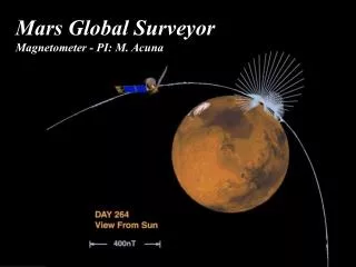
Modern ExplorationGlobal Surveyor • Instruments • Mars Orbiter Camera (MOC); capture high-resolution images of the surface (1.5 meters per pixel) • Thermal Emission Spectrometer (TES); investigate thermal properties of rocks and soils, collect mineralogy data • Mars Orbiter Laser Altimeter (MOLA); elevation data • Magnetometer/Electron Reflectometer; search for evidence of a planetary magnetic field
Modern ExplorationGlobal Surveyor Credit: Malin Space Science Systems – www.msss.com Credit: Malin Space Science Systems – www.msss.com
Modern ExplorationGlobal Surveyor Credit: Malin Space Science Systems – www.msss.com Credit: Malin Space Science Systems – www.msss.com
Modern ExplorationGlobal Surveyor Credit: Malin Space Science Systems – www.msss.com Credit: Malin Space Science Systems – www.msss.com
Modern ExplorationGlobal Surveyor Credit: Malin Space Science Systems – www.msss.com
Modern ExplorationGlobal Surveyor Credit: NASA/JPL/ASU
Modern ExplorationGlobal Surveyor Credit: NASA/Goddard Space Flight Center
Modern ExplorationGlobal Surveyor Credit: NASA/Goddard Space Flight Center
Modern ExplorationGlobal Surveyor • Notable results from Global Surveyor • The northern hemisphere is probably just as cratered as the southern hemisphere, but the craters are mostly buried. • High-resolution imagery shows modifications to the surface have taken place over the past decade. • Hundreds of gullies were discovered that were formed from liquid water (probably), possibly in recent times. • The Thermal Emission Spectrometer found that just about all of the surface of Mars is covered with volcanic rock. • Magnetometer data show remnant, alternating magnetic fields
Modern ExplorationGlobal Surveyor • How did Global Surveyor advance scientific understanding of Mars? • Smoking gun evidence that liquid water was stable on the surface for long periods of time • Mars exhibits a “global dichotomy” in terms of topography • Spectral ID of the global surface composition • What technological advance(s) did Global Surveyor carry? • Highest-resolution camera, for the time • Laser altimeter • TES; lithology, mineralogy • Magnetometer; remnant magnetic field
Modern ExplorationMarsPathfinder • The primary mission objectives were to demonstrate the feasibility of low-cost landings on, and exploration of, the Martian surface (Faster, Better, Cheaper) • Scientific objectives included • atmospheric entry science • long-range and close-up surface imaging • the general objective was to characterize the Martian environment for further exploration
Modern ExplorationMars Pathfinder • Landed in Ares Vallis which was believed to be the site of an ancient flood • Landing site selection made using Viking orbiter imagery • First rover; first to use airbags
Modern ExplorationMars Pathfinder • Landing Site Locations
Modern ExplorationMarsPathfinder • Pathfinder Landing Site
Modern ExplorationMars Pathfinder • Lander Instruments • Imager for Mars Pathfinder (IMP) • Meteorological Station • Rover Instruments • Three cameras, two stereo cameras in the front and a rear color imaging system; cameras worked in tandem with a laser system to detect and avoid obstacles • Alpha-Proton-X-Ray Spectrometer (APXS); assess the composition of rocks and soils
Modern ExplorationMars Pathfinder • Notable results from Pathfinder • More than 16,500 images from the lander and 550 images from the rover • More than 15 chemical analyses of rocks and soil and extensive data on winds and other weather factors • Findings from the investigations carried out by scientific instruments on both the lander and the rover suggest that Mars was at one time in its past warm and wet, with water existing in its liquid state and a thicker atmosphere
Modern ExplorationMars Pathfinder • How did Pathfinder advance scientific understanding of Mars? • Evidence on the ground for a warm, wet past • What technological advance(s) did Pathfinder carry? • First rover; can be remotely operated • New landing system
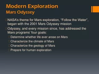
Modern Exploration • NASA’s theme for Mars exploration - Follow the Water - began with the 2001 Mars Odyssey mission • Odyssey, and every mission since, has addressed the Mars programs’ four goals: • Determine whether life ever arose on Mars • Characterize the climate of Mars • Characterize the geology of Mars • Prepare for human exploration
Modern ExplorationMars Odyssey • Objectives: • Determine the abundance of hydrogen, most likely in the form of water ice, in the shallow subsurface • Globally map the elements that make up the surface • Acquire high-resolution thermal infrared images of surface minerals • Provide information about the structure of the Martian surface • Record the radiation environment in low Mars orbit as it relates to radiation-related risk to human exploration
Modern ExplorationOdyssey • 3 instruments: • Thermal Emission Imaging System (THEMIS); mineralogy • Gamma Ray Spectrometer (GRS); elemental composition • MartianRadiation Environment Experiment (MARIE)
Modern ExplorationOdyssey Credit: NASA/JPL/University of Arizona
Modern ExplorationOdyssey Credit: NASA/JPL/University of Arizona
Modern ExplorationOdyssey Credit: NASA/JPL/University of Arizona
Modern ExplorationOdyssey • Notable results from Odyssey • Evidence for vast amounts of subsurface water ice at both polar regions • Can you see it?
Modern ExplorationOdyssey Credit: NASA/JPL/University of Arizona
Modern ExplorationOdyssey • Notable results from Odyssey • Evidence for vast amounts of subsurface water ice at both polar regions • Can you see it? • Where is it? • Underneath the surface but… • How deep? • Is it dirty ice? Or icy dirt?
Modern ExplorationOdyssey • How is Odyssey advancing scientific understanding of Mars? • Water-ice exists underneath the surface in the polar regions, not just at the poles • What technological advance(s) does Odyssey carry? • GRS; able to “look” below the surface