Download
1 / 17
170 likes | 356 Views
Monitoring the Global Sea Level Rise Budget with Jason, Argo and GRACE Observations. Eric Leuliette and Laury Miller NOAA /Laboratory for Satellite Altimetry. Ocean Climate Observation 7th Annual System Review • Silver Spring, Maryland • 27–29 October 2010 . NOAA Jason Program.

E N D
Monitoring the Global Sea Level Rise Budget with Jason, Argo and GRACE Observations Eric Leulietteand Laury Miller NOAA/Laboratory for Satellite Altimetry Ocean Climate Observation 7th Annual System Review • Silver Spring, Maryland • 27–29 October 2010
Multiple agency efforts underway: • NOAA CDR Program (NCDC) • NASA Measures Program • ESA Climate Change Initiative • SCOPE-CM (Operational meteorological agencies: EUMETSAT, NOAA, JMA, CMA) Sea Level Climate Data Records For practical purposes, the Ocean Surface Topography Science Team (OSTST), jointly led by NOAA, NASA, EUMETSAT & CNES, will be the focal point.
Iconic Climate Time Series Global Mean Sea Level Anomaly CO2 at Mauna Loa Ocean Climate Observation 7th Annual System Review • Silver Spring, Maryland• 27–29 October 2010
The Challenge Ensemble mean steric sea level change (m), 2091-2100 wrt 1980-2000, from 12 AR4 models. (Yin et al., JCLIM, 2010) ? TOPEX/Jason sea level trends (steric & eustatic) 1992 to 2010 Ocean Climate Observation 7th Annual System Review • Silver Spring, Maryland• 27–29 October 2010
Sea Level Budget • SLtotal= SLsteric+ SLmass Total sea level • Tide gauge calibration shows offset November 2009 • Trends in coastal/shallow water are significantly larger than global sea level rise • Steric sea level • Argo coverage and pressure sensor issues • Ocean mass • Differences depending on processing center • Glacial isostatic adjustment models
Tide gauge calibration Mitchum tide gauge calibration “Single mission” TX/J1/J2 combination calibration Jason-2 ~1 cm offset in November 2009?
Recent drift/offset in all altimeters Apparent drifts/offsets in the altimeter — tide gauge residuals for Jason-1, Jason-2, and Envisat in late (November) 2009.
No offset in Jason-2 sea level Jason-2 MSL residuals after removing trend, annual, semi-annual, and 59-day terms
Possible causes of offset/drift Common to all altimeter calibrations Tide gauges Instrument and datum shifts Vertical land motion Meteorological fields Dry troposphere • Inverted barometer correction is not applied for calibration Reference frame Independent causes Wet troposphere
Earthquakes near gauges Two relatively large earthquakes struck near gauges at roughly the time of the offset M 8.1, Samoa, 29 September 2009 M 7.3, 100 km, Suva, Fiji, 9 November 2009 M 6.8, 135 km, Nuku'Alofa, Tonga, 24 November 2009. GPS vertical motion at Pago Pago SOPAC GPS vertical solutions for Pago Pago show large post-seismic motion opposite of the long-term trend
Contributions to offset from gauges Contribution to Jason-2 offset from individual tide gauges weighted differences in mean bias for Nov. 2009 ± 5 months The offset is seen by the entire tide gauge network Pago Pago
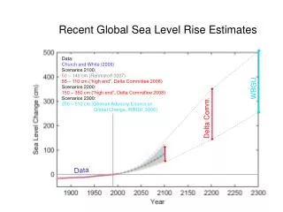
Trends in sea level 20th century rate of sea level rise: 1.7 ± 0.3 mm/yr Rate during altimetry era (1992–2010): 3.3 ± 0.4 mm/yr • (when corrected for GIA effect of +0.3 mm/year)
Sea level rise near coasts • Since 2002 coastal sea level rise has been significantly larger than global • Trends from 2005.5 to 2010.5 • Complete Jason coverage area: 2.6 mm/year • > 120m depth 2.3 mm/year (sealevel.colorado.edu) • > 200 km from the coast 1.9 mm/year (Leuliette & Miller 2009) Trends 2005 – 2010.5 Trends versus distance
Ocean mass: geoid change Ocean mass variations observed directly from GRACE have little trend for 2004 – 2010. A complete analysis must account for ocean mass changes “masked” by geoid variations from the solid Earth’s response to ice melt since the last ice age (Glacial Isostatic Adjustment, GIA) • Published results differ more than forcing uncertainty (~20%) Peltier (2004, 2009) +1.9 mm/year Paulson et al. (2007), Tamisiea (2010) +1.0 mm/year 15
Budget results Trends for Components of Sea Level Rise and Total Sea Level (2004 – 2010.25)
Discussion While the 6-year “global” budget can be closed within 90% confidence intervals, “global” excludes > 66°, < 200 km from coasts, and > 900 m depth (Argo) Total sea level Tide gauge calibration issue needs to be resolved to ensure the integrity of the sea level CDR Steric sea level Global analyses are preliminary until pressure drift issues are resolved Ocean mass Consensus on GIA correction: Paulson, et al. (2007) and Tamisiea (2010) are appropriate for ocean mass trends NASA has included the rapid follow-on to GRACE in its budget for a start in FY2011 with launch by 2016 • Heavily focused on maintaining data continuity from GRACE and minimizing any data gap after GRACE. Ocean Climate Observation 7th Annual System Review • Silver Spring, Maryland• 27–29 October 2010