Download
1 / 4
40 likes | 136 Views
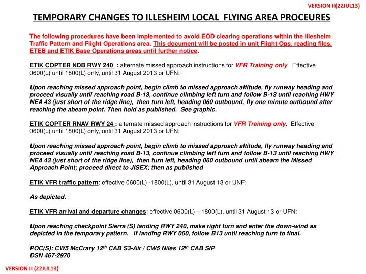
VERSION II(22JUL13). TEMPORARY CHANGES TO ILLESHEIM LOCAL FLYING AREA PROCEURES.

E N D
VERSION II(22JUL13) TEMPORARY CHANGES TO ILLESHEIM LOCAL FLYING AREA PROCEURES The following procedures have been implemented to avoid EOD clearing operations within the Illesheim Traffic Pattern and Flight Operations area. This document will be posted in unit Flight Ops, reading files, ETEB and ETIK Base Operations areas until further notice. ETIK COPTER NDB RWY 240 : alternate missed approach instructions for VFR Training only. Effective 0600(L) until 1800(L) only, until 31 August 2013 or UFN: Upon reaching missed approach point, begin climb to missed approach altitude, fly runway heading and proceed visually until reaching road B-13, continue climbing left turn and follow B-13 until reaching HWY NEA 43 (just short of the ridge line), then turn left, heading 060 outbound, fly one minute outbound after reaching the abeam point. Then hold as published. See graphic. ETIK COPTER RNAV RWY 24 : alternate missed approach instructions for VFR Training only. Effective 0600(L) until 1800(L) only, until 31 August 2013 or UFN: Upon reaching missed approach point, begin climb to missed approach altitude, fly runway heading and proceed visually until reaching road B-13, continue climbing left turn and follow B-13 until reaching HWY NEA 43 (just short of the ridge line), then turn left, heading 060 outbound until abeam the Missed Approach Point; proceed direct to JISEX; then as published ETIK VFR traffic pattern: effective 0600(L) -1800(L), until 31 August 13 or UNF: As depicted. ETIK VFR arrival and departure changes: effective 0600(L) – 1800(L), until 31 August 13 or UFN: Upon reaching checkpoint Sierra (S) landing RWY 240, make right turn and enter the down-wind as depicted in the temporary pattern. If landing RWY 060, follow B13 until reaching turn to final. POC(S): CW5 McCrary 12th CAB S3-Air / CW5 Niles 12th CAB SIP DSN 467-2970 VERSION II (22JUL13)
VERSION II (22JUL13) TEMPORARY CHANGES TO ILLESHEIM LOCAL FLYING AREA PROCEURES CONTINUATION: OTA arrivals and departures All aircraft departing the airfield for the OTA will fly the traffic pattern , as depicted, and exit the traffic pattern on mid downwind. All aircraft departing the OTA returning to the airfield will enter the, depicted, traffic pattern on mid downwind. All aircraft departing the OTA transitioning to a reporting point will remain south of NEA 43 and the, depicted, traffic pattern. IFRPROCEDURES FOR NDB / GCA Holding at 4500ft at the ILM NDB. When on approach, maintain 4500ft or above until abeam point then descend to normal NDB altitude for approach. If aircraft executes missed approach, IFR procedure will be “climbing right turn heading 350 to 3500ft”. This will be for transient IFR aircraft or if an aircraft encounters Inadvertent IMC conditions. Langen Approach will not be familiar with the alternate instructions so all IFR training will have to be conducted after Griffin Approach opens. EMERGENCY In the event of an aircraft emergency or an aircraft encounters Inadvertent IMC conditions, recommend BDE identifies a POC at the EOD clearing site that can be reached by either Illesheim Airfield or Griffin Approach to cease all demolition activity until the aircraft has landed safely. POC(S): CW5 McCrary 12th CAB S3-Air / CW5 Niles 12th CAB SIP DSN 467-2970 VERSION II (22JUL13)
VERSION II (22JUL13) ETIK MODIFIED TRAFFIC PATTERN (DAY ONLY) UFN ECHO INTERSECTION • Legend • Pattern Altitude: 1800’ MSL • NDB/GPS approaches: • SEE ALT Missed approach Instructions (Attached) • Day Only • Mon-Fri (0600L-1800L) • VALID 22JUL13- UFN 1800’ MSL SIERRA VERSION II (22JUL13)
ETIK VFR TRAINING MISSED APPROACH INSTRUCTIONS VERSION II (22JUL13) 240 DEGREES INTERSECTION 060 DEGREES SIERRA VERSION II (22JUL13)