Download
1 / 10
100 likes | 238 Views
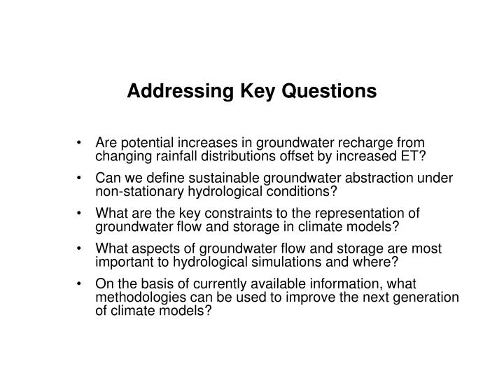
Are potential increases in groundwater recharge from changing rainfall distributions offset by increased ET? Can we define sustainable groundwater abstraction under non-stationary hydrological conditions?

E N D
Are potential increases in groundwater recharge from changing rainfall distributions offset by increased ET? Can we define sustainable groundwater abstraction under non-stationary hydrological conditions? What are the key constraints to the representation of groundwater flow and storage in climate models? What aspects of groundwater flow and storage are most important to hydrological simulations and where? On the basis of currently available information, what methodologies can be used to improve the next generation of climate models? Addressing Key Questions
UNESCO addressing hydrological extremes: knowledge base and capacity for prediction, adaptation and mitigation IFI: International Flood Initiative International Centre for Water Hazard and Risk Management (ICHARM) (Tsukuba, Japan) IIASA
Topics Initial Partners and Lead Research Education and Training Information Networking Empowering Communities Technical Assistance Flood Risk Management Multi - hazard analysis IAHS ICAHRM UNESCO WMO IAHS UNESCO FRIEND WMO, IAHS UNESCO FRIEND WMO, IAHS UNESCO FRIEND WMO, IAHS Data for risk assessment IAHR, IAHS UNESCO FRIEND ICHARM IAHR, IAHS, UNESCO FRIEND ICHARM IAHR, IAHS, UNESCO FRIEND ICHARM, ISDR IAHR, ISDR, IAHS UNESCO Hydrologic, hydraulic and economic modeling IAHR, IAHS ICHARM UNESCO IAHR, WMO IAHS, ICHARM UNESCO IAHR , WMO IAHS, ICHARM UNESCO IAHR, WMO, IAHS UNESCO Flood hazard mapping IAHS ICHARM IAHS, ICHARM WMO, IAHS ICHARM WMO WMO, IAHS Structural and non-structural measures IAHR, IIHP ICHARM IAHR, IHP, WMO ICHARM IAHR, ICHARM IAHR, WMO Governance and participation People networking ISDR ISDR, UNU Institutional reform ISDR ISDR, WMO WMO Developing stakeholder processes ISDR ISDR Implementation
Flood activities of FRIEND regional groups Flood forecasting hydrological processes linked with heavy rains Techniques for extreme rain fall and flood runoff estimate Methodologies for reliable inundation mapping" through flood risk maps and vulnerability maps. Stochastic modelling of heavy precipitation for runoff forecasting Enhanced understanding forecasting and management of flash floods in urban areas Tools for warning and forecasting in ungauged basins
UNESCO-IHE Activities on Flood Risk Management • Flood resilience • Floating buildings • Re-designing urban areas • Innovative integrated urban water management • Improving Flood Warning • Developing flexible, appropriate software tools for real-time flood prediction • Examining the effect of climate variability/change • Innovative ICT: Using SMS messaging for flood warning by location
Assessment of Flood Forecasting and Warning System for Humid Tropic Regions Partners:UNESCO-IHP Jakarta office and ICHARM and HTC Established in Indonesia, Malaysia, the Philippines, Thailand and Vietnam
“Management of Water Related Disasters in Changing Climate”IFI Book Series • Extreme precipitation and climate change (by R. Teegavarapu) • Hydrologic modeling of floods (by P. Mujumdar) • Hydraulic modeling of floods (by G. Di Baldassarre) • Flood risk management (by S. Simonovic)
Sedimentation problems are matter of global concern • the annual erosion of surface soil from global river basins amounts to 60 billion tons • 5 to 7 million ha of farmland are annually ruined • about 1% of the precious storage capacity of the world's reservoirs is annually lost to deposition • Economic Loss over USD 6 billion/year
International Sediment Initiative (ISI) Objectives: • promote the elaboration and monitoring of sediment data • develop appropriate methods and procedures in sediment management Recent Activities: • Global evaluation of sediment transport • Case studies for river basins, review of erosion and sediment related research • Global erosion and sediment information system (UNESCO IRTCES center, Peking) • Networking, education and training
Are the sediment loads of the world’s rivers currently changing in response to these components of global change?