Download
1 / 23
230 likes | 364 Views
Chapter 6. Spatial Joins . Which county has most earthquakes?. County data layer Earthquake data layer No common field between layers. Spatial Joins. A spatial join is based on the location of spatial features rather than common field.

E N D
Chapter 6 Spatial Joins
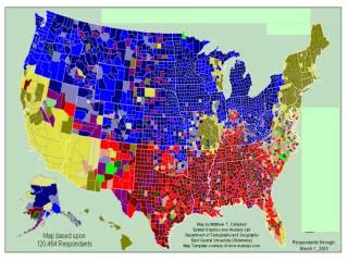
Which county has most earthquakes? County data layer Earthquake data layer No common field between layers
Spatial Joins • A spatial join is based on the location of spatial features rather than common field • Spatial join may create new attributes, such as count or distance in the output data
Spatial Join Target layer Join Layer Output Layer
Spatial Join Counties showing the frequency of earthquakes
Spatial Joins Spatial join can be used to find: • The closest feature to another feature. • What features in one layer are inside another feature. • What intersects a feature. Spatial join creates a new layer from two input layers by combining both sets of attributes. However, it does not combine the features to the target layer
Which watershed has the highest number of septic systems? Watershed Septic System
Count field shows the # of septic system in each watershed Color coded Watershed
Two options • How many points are closest to it including the summary statistics of closest points 2. Closest point to the target layer including the distance Spatial Join(Point to point)
Spatial Join(Point to point) Use Option 1 without any summary:
Option 1 add only the Count field in the output layer showing the number of cities that are closest to each hospital Which hospital is the closest to most cities? No distance field in the output layer
Spatial Join(Point to point) Example: Total number of people served by each hospital In this case you have to use Summarized under Option1
Spatial Join(Point to point) Example: Total number of people served by each hospital Summarized option will give summary statistics on each numeric field including the count(# of cities)
This hospital serve most of the cities This hospital serve most of the people Spatial Join(Point to point) Example: Total number of people served by each hospital
Use option 2 Which town is farthest/closest from a hospital?
Spatial Join: Point to point-Distance Each town features gets name of closest hospital and the distance. Get the closest or farthest city by sorting the distance
Example: Which counties are within a watershed Same county will fall in more than one watershed, as a result duplication will occus in count and also in summary statistics!!
Spatial join Never use the unprojected data for distance calculation! You will not only get wrong distance but wrong selection as well !!