Download
1 / 74
740 likes | 1.08k Views
Unit One. Brief Introduction to the Yangtze Three Gorges for Tourists. Qinghai-Tibetan Plateau. Brief Introduction to the Yangtze Three Gorges for Tourists. The Source and the Names for Different Sections. The Resources and the Climate. Geographical Position of the Main Tourist

E N D
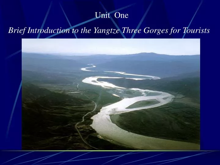
Unit One Brief Introduction to the Yangtze Three Gorges for Tourists
Brief Introduction to the Yangtze Three Gorges for Tourists The Source and the Names for Different Sections The Resources and the Climate Geographical Position of the Main Tourist Attractions in the Yangtze Three Gorges Area The Outline of the Yangtze Three Gorges Tourist Routes
The Yangtze River, which rolls on and on, is called the mother river of the Chinese nation. It rises in the Qinghai-Tibetan Plateau where glaciers (冰川)pile one upon another and undulating(起伏的) snowy mountains stretch for kilometers. Fed by hundreds of thousands of streams and rivers, itswells(扩大) into a formidable(令人惊叹的) torrent in the Sichuan Basin. The Yangtze River flows through the Sichuan Basin to Fengjie in the east, pushes its way through high mountains and towering ridges (山脊;分水岭)to Nanjin Pass in Yichang, forms magnificent and matchless valleys—the Three Gorges,
which are the most spectacular pearl inlaid on the Yangtze River and ranked as one of the 10 top scenery areas in China. Consisting of the following three sections——Qutang Gorge, Wu Gorge and Xiling Gorge, the Three Gorges are the sole canyon for tourists to visit the whole course in the world. The Three Gorges have an ineffable(不可言喻的) scenery. The splendors(壮观)of Qutang Gorge, the elegance of Wu Gorge and the adventurousness(险峻) of Xiling Gorge form the majestic(雄伟的) picture of this world-renowned tour resort.
Every peak and every part of the water can be the object of a painting orinspiration(灵感) of a poem. The legends and fairy tales about this place make it even more enchanting(迷人的). The beautiful landscape of the Yangtze Three Gorges, which gave birth to a splendid ancient civilization of China, tends to produce outstanding people. There are many famous scenic spots and historical sites, which form anintegral(完整的) part and enjoy a high reputation in the world.
There are also some interesting local customs. For instance, the Taqi in Fengjie, the dragon boat race in Zigui, the baskets carried on the back in Badong, the peculiar marriage and funeral ceremony of Tu ethnic(少数民族的) people, and so on. Now the world-famous Three Gorges Project is under construction. When it’s finally completed in 2009, it will add another tourist attraction to the beautiful landscape of the Three Gorges, and the scenery in this area will be even more attractive and beautiful than ever.
Translation: 长江三峡旅游概要 奔流不息的长江,被称为中华民族的母亲河,她发源于“世界屋脊”青藏高原的雪山冰川之中,携纳了沿途的百河千川,在四川盆地汇成了一条浩浩荡荡的激流。 长江流经四川盆地东侧的奉节,冲开崇山峻岭的阻挡,夺路东去,直到宜昌的南津关,形成壮美雄奇、举世无双的大峡谷,这就是镶嵌在万里长江上的一颗璀璨明珠——长江三峡,它被列为中国十大风景名胜之一。长江三峡由瞿塘峡、巫峡和西陵峡三个峡段组成,是世界上唯一能供大众全程游览的峡谷。 长江三峡,风光无限。瞿塘峡的雄伟,巫峡的秀丽,西陵峡的险峻,使这驰名世界的旅游胜地气象万千。
三峡的一山一水,一景一物,无不如诗如画,并伴随着许多美丽的神话和动人的传说,令人心驰神往。长江三峡,人杰地灵,这里是中国古文化的发源地之一,这里有许多著名的名胜古迹,它们同旖旎的山水风光交相辉映,名扬四海。长江三峡,风情绚丽,奉节的踏碛日,如一副优美的风俗画;秭归的龙舟赛,似一首磅礴的交响乐;沿着江边的一级级石阶,可到巴东去欣赏那奇特的背篓世界;顺着弯弯的山路,可到土家山寨参加别致的跳丧哭嫁的仪式。现在,举世瞩目的三峡工程正在兴建之中。到2009年建成之后,它将给三峡这举世闻名的旅游胜地增添更加绚丽多姿的景象,长江三峡将以更加妩媚的容貌出现在世人面前。 三峡的一山一水,一景一物,无不如诗如画,并伴随着许多美丽的神话和动人的传说,令人心驰神往。长江三峡,人杰地灵,这里是中国古文化的发源地之一,这里有许多著名的名胜古迹,它们同旖旎的山水风光交相辉映,名扬四海。长江三峡,风情绚丽,奉节的踏碛日,如一副优美的风俗画;秭归的龙舟赛,似一首磅礴的交响乐;沿着江边的一级级石阶,可到巴东去欣赏那奇特的背篓世界;顺着弯弯的山路,可到土家山寨参加别致的跳丧哭嫁的仪式。现在,举世瞩目的三峡工程正在兴建之中。到2009年建成之后,它将给三峡这举世闻名的旅游胜地增添更加绚丽多姿的景象,长江三峡将以更加妩媚的容貌出现在世人面前。 back
Passage 1 The Source and the Names for Different Sections
The Changjiang River is the longest River in Asia, the third in the world, with the Amazon River in South America and the Nile River in Africa as the first and second respectively. For thousands of years, the opinions on the source of the Changjiang River had differed greatly. In 1976, the Yangtze Valley Planning Office undertook the first source exploration. On the 13th of January in 1978, the result of exploration was announced by the Xinhua News Agency:
the source of the Yangtze River was at “theTuotuo River” on the south–west side of Mount Geladandong, the main peak of Tanggula Moutain in Qinghai-Tibetan Plateau. Originating from “the Tuotuo River”, the Changjiang River flows eastward through 11 provinces, cities and autonomousregions of Qinghai, Tibet, Sichuan, Yunnan, Chongqing, Hubei, Hunan, Jiangxi, Anhui, Jiangsu, Shanghai, and finally into the East Sea on the east side of the Chongming Island. The main river course of the Changjiang River is beyond 6300 kilometers
long with more than 10,000 tributaries, and the area of the whole valley is 1.8 million square kilometers which holds about one fifth of the nation’s land. The Changjiang River was called “the River” or “the Grand River” in ancient times. Quite a few other countries in the modern times named it “the Yangtze River”. However, there are no less than 30 formal and informal names for the different sections of the Changjiang River. Usually, the section from the start to Dangqukou is called “the Tuotuo River” and is known as the very source of the Changjiang River;
The section from Dangqukou to Batanghekou of Yushu County, Qinghai Province is named “the Sky Reaching River”; and the section from Batanghekou to Minjiangkou in Yibin, Sichuan Province is known as “the Jinsha River”; downstream from Minjiangkou to the sea, the river is formally considered as “the Changjiang River”. However, this main section is also divided into several parts: “the Chuanjiang River ” from Yibin to Yichang in Hubei Province; “the Jingjiang River” from
Zhicheng in Hubei Province to Chenglingji in Hunan Province; the “the Xunyangjiang River” near Jiujiang in Jiangxi Province; “the Yangtze River” near Yizheng and Yangzhou in Jiangsu Province. Traditionally, the 4500 km long section from the source to Nanjin Pass in Yichang, Hubei Province is known as the upper reaches of the river; the 955 km long section from Yichang to Hukou in Jiangxi Province is known as the middle reaches and 938 km long section from Hukou to the river mouth is known as the lower reaches.
Notes: 1. 格拉丹东:藏语里意为“高高尖尖的山”。格拉丹东雪山主峰海拔6621米,山顶如晶莹夺目的冰雕尖塔,雄伟峻峭,高入云端,拔立于雪山群峰之上,景色奇丽,气象万千。 2. “扬子江”的由来:江苏省仪征,扬州市一带的长江河段,古称扬子江,因扬子津及扬子县而得名。早在隋代,扬州地区已有扬子津、扬子桥等地名。扬子津为古津渡名,位于今扬州市南,古时可由此南渡京口(即今镇江市),为江滨要津。隋炀帝曾临此津,寻置扬子宫,在今扬州南20里,后名扬子镇,在今仪征境内。到宋代,扬子江之名已散见诗文中,如“闲观扬子江心浪,静听金山寺里钟。”近代一些西方国家入侵长江,先进入下游扬子江段,扬子江一名就被泛指整个长江了。 3. originate from:发源于;来自于 e.g. Her novel originated from a famous folk story. 4 .no less than:多达 e.g. There were no less than fifty wounded in this traffic accident.
New Words: respectively ad. 分别地; 各自地 peak n. 山峰;山顶 plateau n. 高原 province n. 省;行政区 autonomous a. 自治的 region n. 地区;区域 downstream ad. 顺流 地;在下游 Tibet n. 西藏 tributary n. 支流 informal a. 非正式的 Traditionally ad. 惯例地; 传统地 upper a. 上面的; 较上的
Exercises: I. Answer the questions: 1. When did the first source exploration of the Changjiang river begin ? 2. Where is the source of the Changjiang River ? 3. How many names does the Changjiang River go by? 4. How many square kilometers is the area of the Changjiang River Valley? 5. How is the Changjiang River divided into the upper, middle, and lower reaches? Key
II. Decide the staments true or false: 1. The Amazon River is the second longest river in the world. ( ) 2. The section from Dangqukou to Batanghekou is called “the Tuotuo River”. ( ) 3. The Changjiang River flows into the East Sea of China . ( ) 4. The lower reaches of the Changjiang River is 938 kilometers. ( ) 5. The Changjiang River flows eastward through 13 provinces, cities, and autonomous regions. ( ) Key
III. Multiple choices: 1. The third longest river in the world is ______. A. the Congo River in Africa B. the Changjiang River in Asia C. the Amazon River in the South America D. the Nile River in Africa 2. The section from Yibin to Yichang is called A. the Jingjiang River B. the Xunyangjiang River C. the Jinsha River D. the Chuanjiang River 3. The Changjing River ______ from “the Tuotuo River” on the south-west side of Mount Geladandong Key
A. goes B. passes C. originates D. runs 4. The section near Jiujiang in Jiangxi Province is called ______. A.the Xunyangjiang River B .the Jingjiang River C. the Yangtze River D. the Chuanjiang River 5. ______countries in the modern times named the Changjiang River “ the Yangtze River” according to the passage. A. A large amount of B. Quite a few C. A good quantity of D. A great number of Key
Translation: 长江的源头和分段名称 长江是亚洲第一、世界第三大河,仅次于南美洲的亚马逊河和非洲的尼罗河。 千百年来,有关长江的源头可谓众说纷纭。1976年,长江流域规划办公室组织首次江源考察。1978年1月13日新华社公布了考察结果:长江的源头在青藏高原的唐古拉山主峰格拉丹东西南侧的沱沱河。长江发源于沱沱河,然后流经青海、西藏、四川、云南、重庆、湖北、湖南、江西、安徽、江苏、上海等11个省、市、自治区,最后在崇明岛以东注入东海,干流全长6300余公里,有大小支流1万多条,流域面积180万平方公里,约占全国总面积的五分之一。
长江古名“江”,又称“大江”,近代不少国家还把整个长江称为“扬子江”。长江各段名称和别名总计不少于30个,一般常用的分段名称有:从江源至当曲口,称“沱沱河”,为长江正源;当曲口至青海省玉树县巴塘河口,称“通天河”;巴塘河口至四川省宜宾市岷江口,称“金沙江”;岷江口至长江入海口,通称“长江”。其中,宜宾至湖北省宜昌段,又称“川江”;湖北枝城至湖南城陵矶段,又称“荆江”;江西九江附近江段,又称“浔阳江”;江苏省仪征、扬州市附近,又称“扬子江”。长江按习惯性划分,通常把源头到湖北宜昌南津关段称为上游,长约4500公里;宜昌至江西省湖口为中游,长955公里;湖口以下至长江口为下游,长938公里。 back
Passage 2 The Resources and the Climate
The Yangtze River’s annual water flow into the sea at the river mouth is 1000 billion cubic meters, which is 20 times that of the Yellow River, and one third of our country’s total. It ranks the third in the world, with the Amazon in South America and the Congo in Africa as the first and the second. The total water drop from the source to the river mouth is more than 5800 meters, which is much larger than that of
Yellow River and can’t be matched anywhere in the world. The potential of the hydroelectric power may reach as much as 0.27 billion kilowatts .This is equivalent to 40% of China’s total or that of the three countries of the United States, Canada and Japan all together. Approximately 0.2 billion kilowatts of power can be developed, which is 50% of the total in our country. The Yangtze River gains the name “Gold
Waterway” because of its wide surface and deepnavigation system and thus becomes the main water traffic artery of the South China. Now the navigation waterway of the river and its main tributaries is 96,000 km long, which is two and a half times circumference of the earth. The annual waterway transportation capacity occupies as much as 70% of the total of China. The Yangtze River Valley stretches from Qinghai-Tibetan Plateau in the west to the Pacific Ocean in the east,
and is located in thesubtropical zone. Due to the air circulation, it has a typical subtropical monsoon climate with four distinguishing seasons. The main characteristic of this climate is hot in summer and cold in winter, with obvious dry and wet seasons. In summer, wind blows from the southeast, bringing the hot and humid air flow from the ocean and makes the whole river valley high in temperature, humid and abundant in rain.
In winter, wind blows from the northwest, Mongolia and Siberia, bringing the chilly wind southward to make the whole valley cold, dry and short of rain. However, with such a large area and complicated geographical conditions, there exist different forms of climate across the valley. For instance, it is as cold as winter all year round in the river source area; While in the Jinsha River area, the typical vertical climate gives the same mountain different seasons in the same day.
The weather varies even a few kilometers away, such as in Emei Mountain area in Sichuan Province. It has 4144 hours average annual rain time, which means heavy rains almost every other day. No wonder the place gets the byname “Leak of the Heaven”. The complicated geological conditions in Yangtze River Valley make mine deposits possible and thus the valley is rich in underground mine resources and is known as “the Treasure Bowl of China” ;.The 0.4
billion mu of fertile cultivated land makes the valley the most important agricultural and stockbreeding base. Many important industrial and port cities such as Chongqing, Wuhan, Nanjing and Shanghai are located along the river. About 0.4 billion people and more than 30 national groups live in the valley, with 95% of Hans and other minorities, such as Miao, Yao, Tibetan,Zhuang, Bai, Tong, Tujia, Naxi. In a word, The Yangtze River is really worthy of the title “the Cradle of the Chinese nation”.
Notes: 1. no wonder (that) : 难怪 e.g. No wonder you couldn’t find the book—it had fallen behind the chair. 2. is worthy of: 值得……的 e.g. Her brave deeds are worthy of the teacher’s praise. New Words: annual a. 每年的 cubic a. 立方体的 potential n. 蕴藏量 hydroelectric a.水力发电的 distinguishing a.差异明显的 characteristic n.特点;特征 abundant a.丰富的;充裕的 southward ad. 向南
equivalent a. 相等(当)的 approximately ad. 大约 navigation n. 航行 artery n. 动脉;干线 circumference n.周长;圆周 subtropical a.亚热带的 circulation n.循环; 环流 monsoon n. 季风 vertical a. 垂直的; 直立的 geological a. 地质的 geographical a.地理的;地 形的 deposit n. 沉积物;矿床 fertile a. 肥沃的; 富饶的 cultivated a. 耕种的; 耕作的 stockbreeding n. 畜牧业 minority n. 少数民族
Exercises: I. Answer the questions: 1. How many cubic meters is the annual water flow at the estuary of the Yangtze River ? 2. Where is the Sky Reaching River located ? 3. How much is the potential of hydroelectric power of the Yangtze River ? 4. Why do people call the Yangtze River “ the Gold Waterway” of China ? 5. What’s the climate characteristic of the Yangtze Valley ? II. Decide the statements true or false: Key
1. The annual waterway transportation capacity of the Yangtze River and its main tributaries occupies as much as 70% of the total in China. ( ) 2. The Yangtze River Valley is located in the subtropical zone. ( ) 3. Emei Mountain area has 4144 hours average annual rain time. ( ) 4. There are 0.4 million mu of fertile cultivated land in the whole Yangtze River Valley. ( ) 5. There are about 20 national groups living in the Yangtze River Valley. ( ) III. Multiple choices: 1. The Yangtze River’s annual water flow into the sea at the estuary is _____of the total in China. A.1/2 B. 1/3 C. 1/4 D. 1/5 Key
2. The navigation waterway of the Yangtze River and its main tributaries is _____ long. A. 66,000 km B. 76,000 km C. 86,000 km D. 96,000 km 3 .______the air circulation, the Yangtze River Valley has a typical subtropical monsoon climate with four distinguishing seasons. A. Since B. Because C. Due to D. As 4. The total water drop from the source to the river mouth is more than ______ meters. A. 5800 B. 4800 C. 3800 D. 2800 5. The annual water flow into the sea at the mouth of the Yellow River is______ that of the Yangtze River. A. one fifth B. one tenth C. one fifteenth D. one twentieth Key
Translation: 资源和气候 长江每年通过河口入海的水量达1万亿立方米,是黄河的20倍,占中国所有江河年入海总水量的1/3以上,仅次于南美洲的亚马逊河和非洲的刚果河,排名第三。长江从源头到入海口的总落差有5800多米,比黄河的总落差要大得多,在世界上也是无与伦比的。长江水能蕴藏量达2.7亿千瓦,占中国水能蕴藏量的40%,相当于美国、加拿大、日本三国水能蕴藏量的总和。长江流域可开发的水力资源总装机容量近2亿千瓦,占全国的50%以上。长江江阔水深,是我南方的交通大动脉,素有“黄金水道”之称,现在长江的主干流通航里程达9.6万公里,可绕地球两周半,年货运量占全国河流总运输量的70%。
长江流域西源于青藏高原,东临太平洋,地处亚热带,又有明显的大气环流,四季分明,其气候为典型的亚热带季风气候。冬冷夏热,干湿季节分明是它的基本特点。夏季盛行偏南风,从海洋来的暖湿气流使长江流域温高、湿润、多雨。冬季则盛行偏北风,来自西北、蒙古和西伯利亚的干冷空气控制全流域,天气寒冷、干燥、少雨。当然,长江流域地域辽阔,地理环境复杂,各地气候又有明显差异。如江源地区四季如冬;金沙江地区有“一山有四季,十里不同天”的立体气候特征;而四川省的峨眉山区,年平均降雨时数达4144小时,几乎每两天会有一天像天破漏雨,有“天漏”别名。
长江流域地质条件复杂,成矿条件优越,地下矿藏资源十分丰富,是华夏的聚宝盆;它拥有4亿亩肥沃的耕地,是中国最重要的农业生产基地和重要的畜牧业生产基地;沿江有重庆、武汉、南京、上海等重要工业及港口城市;大约有4亿人口生活在这里,囊括30多个民族,汉族占总人口的95%以上,其余有苗、瑶、藏、壮、白、侗、土家、纳西等少数民族。总而言之,长江无愧被称为中华民族的摇蓝。 back
Passage 3 Geographical Position of the Main Tourist Attractions in the Yangtze Three Gorges Area
Starting from Baidi Town in Fengjie of Chongqing City and finishing at Nanjin Pass of Yichang in Hubei Province, the Three Gorges extend for a distance of 193 kilometers, which are the most concentrated natural “landscape painting galleries” and “cultural corridors” on the tourist line of the Yangtze River. In general, you can start from Chongqing City and finishes in Yichang City when you travel downstream by ship. As the popular tourist cities in China, there are also many attractive cultural and natural interests around the two cities. The geographical position of the main tourist scenic spots in this area presents as follows:
1. The main scenic spots in Chongqing City: The main scenic spots in the central urban area include: Red Shale Village, Nan Shan Park, Liberation Monument, Sculpture of Revolutionary Martyrs at the Cemetery, and so on. The following are the other main scenic spots around the districts under the jurisdiction of Chongqing City: (1).Dazu Stone Carvings: located on the north bank of the Yangtze River and in the west of Chongqing, it’s a general name for grotto arts of bas-reliefs on precipices on North Hill and Baoding Hill in Dazu County 120 kilometers far away from the central
urban area of Chongqing. It’s listed in the Catalogue of World Cultural Heritages by UNESCO in 1999. (2).White Crane Beam: 120 kilometers far away from the central urban area, it’s a 1600m-long and 16m-wide natural stone beam in the Yangtze River north to Fuling District of Chongqing. Engraved with stone fish carvings, it serves as a historical record for dry seasons in the Yangtze River and it’s of great value for scientific research as well as unique artistic value. (3).Fengdu Ghost Town: it’s the largest scenic spot of ghost culture in China, which represents the theme of “Punishing the Evil and Awarding the Good” folk
culture integrated with Confucius, Sakyamuni, Taoism and Buddhism. It’s also called “the Origin of the Legends on Divinities and Ghosts” in China. (4).Shibao Fortress: it was built over 300 years ago during the reign of Wanli Emperor in Ming Dynasty, listed as one of the eight marvelous buildings in the world. (5).ZhangFei Temple: originally located on the south bank of the Yangtze River at the foot of Feifeng Mountain in Yunyang County of Chongqing, it was built in memory of ZhangFei, a famous general in Shu State during the ThreeKingdoms
Period, comprising a complex of unique ancient buildings and exhibiting a majestic air. The temple consists of 7 key buildings: Front palace, Side Palace, Sworn Brothers Buildings, Cloud-view Pavilion, Zhufeng Pavilion, Cuckoo Pavilion and Moon Pavilion. The first five buildings were built in memory of Zhangfei and the last two buildings were built in memory of Du Fu, a famous poet in Tang Dynasty, who stayed there for two years. Actually, this temple is a unique one in memory of both civil and martial figures. In July of 2003, it’s entirely
relocated to the Panshi Town on the south bank of the Yangtze River over 32km upstream and the opposite to the new county town. The first five buildings were built in memory of Zhangfei and the last two buildings were built in memory of Du Fu, a famous poet in Tang Dynasty, who stayed there for two years. Actually, this temple is a unique one in memory of both civil and martial figures. In July of 2003, it’s entirely relocated to the Panshi Town on the south bank of the Yangtze River over 32km upstream and the opposite to the new county town.
2. The main scenic spots in the Qutang Gorge: Located in the west beginning of the Three Gorges, the whole course of the Qutang Gorge is about eight kilometers. Here the main scenic spots are the Ancient Town of Fengjie, White King Town , the Heavenly Pit and Earthly Ravine, the Relics of Daxi Culture, Mengliang Ladder, Bellows Gorge, the Ancient Plank Roads, the SuspendedCoffins, etc. 3. The main scenic spots in the Wu Gorge: The main scenic spots in this section consist of the Minor Three Gorges on the Daning River, the Dachang Town, the Twelve Peaks, the Goddess Peak, etc. 4. The main scenic spots in the Xiling Gorge:
In addition to the Military Book and Sword Gorge, the Ox Liver and Horse Lung Gorge, Huangling Temple, the main scenic spots in the Xiling Gorge also include the following three parts: the scenery area of Yellow Ox Rock, the scenery area of Yiling and the scenery area in the east entrance of the Xiling Gorge. 5. The main scenic spots in Yichang City: The following are the main scenic spots of Yichang: Gezhouba Key Water conservancy Project, the Three Gorges Project, Binjiang Park, Yiling Square, Xiaoting Ancient Battlefields, Changban Po and Guanling Temple, etc. All details can be read in the following units.
New words: divinity n. 神;神力 fortress n. 要塞 relocate v. 重新安置 upstream ad. 往上游 ravine n. 沟壑 suspend v. 悬挂;吊起 coffin n. 棺材;灵柩 military a. 军事的; 军用的 entrance n. 入口;进口 gallery n. 艺术馆 sculpture n. 雕刻作品 martyr n. 烈士 jurisdiction n. 管辖范围 grotto n. 岩洞 bas-relief n. 浅浮雕品 precipice n. 峭壁 heritage n. 遗产;继承物 engrave v. 雕刻 integrate v. 使成一体
Translation: 长江三峡地区 主要景点地理分布 长江三峡西起重庆市奉节县的白帝城,东至湖北省宜昌市的南津关,全长193公里,是长江风景旅游线上最为集中的山水画廊和文明走廊。乘船顺流而下游览三峡一般以重庆为起始港、以宜昌为目的港。它们作为全国的旅游热点城市,也有很多引人如胜的人文景观和自然景观。该地区主要旅游景点的地理分布情况如下: 1.重庆市及其主要景点:中心城区的主要景点有:红岩村、解放碑、南山公园、歌乐山烈士陵园等。辖区内的其它主要景点包括: