Download

1 / 21
210 likes | 221 Views
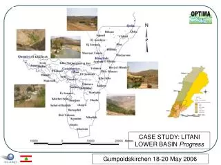
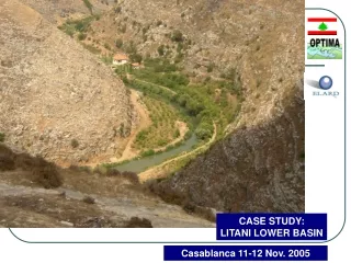
CASE STUDY: LITANI LOWER BASIN Progress. Gumpoldskirchen 18-20 May 2006. The Litani Lower Basin. Intro. The river basin. Stakeholders. WP05. Landuse change. WRM. Obj/Const. Instruments. Conc. LEGEND. 700. 701- 900. Update of the TS daily data. Intro. The river basin.

E N D
CASE STUDY: LITANI LOWER BASIN Progress Gumpoldskirchen 18-20 May 2006
The Litani Lower Basin Intro. The river basin Stakeholders WP05 Landuse change WRM Obj/Const Instruments Conc.
LEGEND 700 701- 900 Update of the TS daily data Intro. The river basin Stakeholders WP05 Landuse change WRM Obj/Const Instruments Conc.
Demographic Change • 105567 capita • 104 communities,5 caza. • 7 towns having a population greater than 3000 2.16-2.2 % yearly demographic increase Intro. The river basin Stakeholders WP05 Landuse change WRM Obj/Const Instruments Conc.
River use Intro. The river basin Stakeholders WP05 Landuse change WRM Obj/Const Instruments Conc.
62km2 (Citrus) • 55km2 (banana) Total: 22 Millions m3/year (Litani water Authority) Litani Irrigation Canal Qasmiyye Intro. The river basin Stakeholders WP05 Landuse change WRM Obj/Const Instruments Conc.
Agriculture ELARD, 2001 Intro. The river basin Stakeholders WP05 Landuse change WRM Obj/Const Instruments Conc.
Institutional Framework* Planning/Supervision MINISTRY OF ENERGY AND WATER Reports to Reports to • INFRASTRUCTURE • Irrigation (Qasmiyye canal, Litani canal 900) • Recreational South Lebanon Water & WastewaterEstablishment Litani Water Authority Reports to • WATER FLOW • WATER QUALITY • DOMESTIC WATER • from Litani River Water Authorities (Jabal Aamel) * “Decrees 5469/1 -5469/16- 5469/25- 5469/40 (1966); Law 121/2001” Intro. The river basin Stakeholders WP05 Landuse change WRM Obj/Const Instruments Conc.
Stakeholders Pub. Auth NGO • Workshop in september 2005 • Workshop report sent to all the stakeholders • Update of stakeholders’ list and information/ (27 qs and 56 stakeholders) • Analysis of proposed objectives and constraints from the workshop • Presentation of the Project progress scheduled with the Litani Authority • Follow up second workshop in August 2006 Intro. The river basin Stakeholders WP05 Landuse change WRM Obj/Const Instruments Conc.
WP05: GIS DATA Metadata Input Intro. The river basin Stakeholders WP05 Landuse change WRM Obj/Const Instruments Conc.
Land Use Change (level) Intro. The river basin Stakeholders WP05 Landuse change WRM Obj/Const Instruments Conc.
Land Use Change Increase in Urban Fabric Intro. The river basin Stakeholders WP05 Landuse change WRM Obj/Const Instruments Conc.
Land Use Change (Banana/Citrus) 1998 Decrease in citrus and banana 2005 Intro. The river basin Stakeholders WP05 Landuse change WRM Obj/Const Instruments Conc.
1998 Land Use Change (Olives) 2005 Decrease in Olives Intro. The river basin Stakeholders WP05 Landuse change WRM Obj/Const Instruments Conc.
WRM Baseline Scenario Intro. The river basin Stakeholders WP05 Landuse change WRM Obj/Const Instruments Conc.
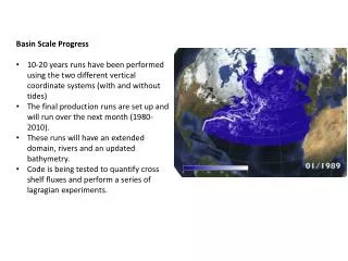
Rainfall Runoff Model (15 subcatchments) Problems with the calibration data Intro. The river basin Stakeholders WP05 Landuse change WRM Obj/Const Instruments Conc.
Criteria (based on issues qs and ws) Intro. The river basin Stakeholders WP05 Landuse change WRM Obj/Const Instruments Conc.
CONSTRAINTS • Environmental Level flow in the river in some portions (especially at the coast) • Supply meeting consumption demand • OBJECTIVES • Increase water demand efficiency • Better exploitation of the River (balanced exploitation) • Control sources of pollution • Decrease losses to the sea Intro. The river basin Stakeholders WP05 Landuse change WRM Obj/Const Instruments Conc.
INSTRUMENTS • Irrigation canal (8.05m3/sec agricultural use and 0.64 m3/sec domestic) cost of 132Million Euros • 2 Dams (128 Millions m3) • Waste water treatment plant(s) • Hydroelectrical plant(s) • Hill lakes • Infrastructure • Update legislation/improve enforcement • Decrease violations on River • Legal • Water pricing • Improvement of the canalization (decrease of losses) • Management • Awareness campaigns • Irrigation technologies (surface irrigation to drip or sprinkle) • Alternative crops (less water consuming) Intro. The river basin Stakeholders WP05 Landuse change WRM Obj/Const Instruments Conc.
PROBLEMS • RRM model (daily data for control points on subcatchment, data cannot be calibrated to a control station) • Water Quality (Stream cannot be used since there were no levels of BOD detected during sampling in the River; potential campaign in summer(?)) FUTURE WORKS • Finalize Baseline scenario (data, economic information, etc.) • Input to WP04 (Instruments and water technologies, cost of infrastructure on the River • Optimization runs • Second workshop to quantify constraints, validate scenarios, in August 2006 after the progress report Intro. The river basin Stakeholders WP05 Landuse change WRM Obj/Const Instruments Conc.