Download
1 / 33
330 likes | 598 Views
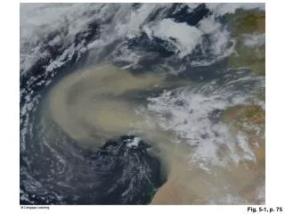
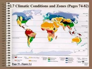
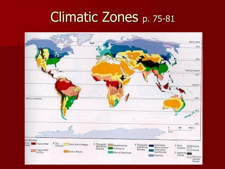
Climatic Zones p. 75-81. P. 75 fig. 5.1. 6 climate regions Each has sub-regions. Tropical Climates - Common. Temp. over 18 0 C every day A relatively flat temperature line Low latitude Between the “Tropics!” Warm ocean currents and Prevailing winds. Tropical Climates-Sub Regions.

E N D
Climatic Zones p. 75-81 P. 75 fig. 5.1
Tropical Climates - Common • Temp. over 180C every day • A relatively flat temperature line • Low latitude • Between the “Tropics!” • Warm ocean currents and • Prevailing winds.
Tropical Climates-Sub Regions • Tropical Wet & Dry Sub- region • Very heavy summer rain • Very dry winter due to seasonal shift in prevailing winds. • Monsoon regions • Seasons- dry or wet • Tropical Wet Subregion • Heavy rain all year due to high temp • Resulting convectional rain. • Precipitation in each month is high
Tropical Wet & Dry - Climate graphs • Precipitation is very high in summer months and very low in winter months • Relatively flat temperature line • Temperature relatively constant & high (19-270C) • Wet and dry seasons • Wet and dry monsoons
Tropical Wet - Climate graphs • Precipitation in each month is high • Temperature constant & high (19-270C) • Relatively flat temperature line
Dry Climates All Dry climates: • < 500mm precipitation annually • More evaporation than precipitation • No cloud cover • High daytime temperatures • Low nighttime temperatures • Temperatures may vary seasonally • Cold ocean currents • Rain shadow areas
Dry Climates • Arid or Desert Subregion • Occur between 10-30oN & 10-30oS • 10-250mm rain annually • Cold ocean currents and rain shadow areas • Hot days but cool nights • Little cloud cover allows heat in during day but heat to escape at night • Semi-arid steppe Sub- Region • Transition Zone between desert & Forest • 250-500mm rain annually • Seasonal shift in prevailing wind • Hot days but cool nights – little cloud cover
Arid - Climate graphs • Arid /desert Climograph p. 76 fig. 5.2 • Below is a climate graph for Berbera, Somalia • Precipitation in each month is low (total less than 250mm) • Temperature may vary seasonally
Semi-Arid - Climate graphs • Monthly precipitation is fairly low • Annual total is less than 500mm • Temperature may vary seasonally
REMEMBER!!!! • The main factor that characterizes the DRY climate zone is the amount of precipitation – there is not very much!
Temperate Mild winter • Temperate Mild Winter • Usually near oceans (coastal) • Four seasons • Higher latitudes result in cooler winters but warm summers • Temperature in coldest month is above –3oC • Close enough to equator to affect temperature
Temperate Mild winterMarine west coast • Coastal regions • Many found on west coast of continents… • Winters are mild • Warmed by warm ocean current • Summers are cool and wet • Orographic precipitation on mountains
Temperate Mild winterMediterranean • Mostly around Mediterranean sea area. (Italy, Greece) • Hot and DRY summers • Wind from land has little moisture • Mild winters • Moderating warm wind from the ocean
Temperate Mild Winter - Subtropical • Close to “Tropics” • Hotter summers • Colder Winters • & More precipitation • Less moderated by ocean but frontal rainfall as polar and tropical air meets • More summer precipitation • Convectional rain due to high temperatures
Which is: Marine West Coast , Mediterranean, Subtropical? Marine West Coast Mediterranean Subtropical
Temperate cold winter Also called Continental Locations generally affected by continentality Generally the mid Latitudes Main distinguishing factor for the 3 subregions in this group is latitude – closer to equator vs. further from the equator Temperature of the coldest month is below –3oC Higher latitudes increase seasonal affect.
Temperate cold winter - Continental Warm Summer Compared to the other sub-regions in this group: • Summer is warmer • Lower latitude -closer to the equator
Temperate cold winter - Continental Cool Summer • Further north than the Continental Warm Summer. • Result - Summer is cooler than in the Continental Warm Summer. • Also means less precipitation than in the Continental Warm Summer.
Continental Subregion * Temp Range increases as you move inland. Away from moderating influence of ocean. * Summer days are very long. Higher latitude – increases effect of earth’s tilt. * Summer temp decreases as latitude increases. Further from direct rays of sun. * Summer has highest precipitation. Frontal rainfall as polar and tropical air masses meet.
Temperate cold winter - Subarctic • Winters are long and very cold – • High latitude • Little precipitation • Too cold • Heavy snow • Too cold for snow to melt
Which is: Continental Warm Summer, Continental Cool Summer, Subarctic? Subarctic Compare precipitation and temperature!! Continental Warm Summer Continental Cool Summer Which is further north??
Polar Region Polar Region • High latitudes • (+60o latitude) • Near poles
POLAR CLIMATES Temperature never goes above 100 C High Latitude Sun may not shine for months High latitudes increase the effect of the tilt of the earth
Polar Region – Tundra • Less severe on the coast • Has moderating influence of the ocean
Polar Region –Ice Cap • More severe inland, away from the ocean • Temperatures never go above 0oC • Continentality makes it colder. • Away from moderating influence of ocean
Ice Cap Which is Tundra, which is Ice Cap? Tundra Notice how little precipitation occurs.
Highlands • Elevations over 1000 m • Colder conditions than the lower lying areas surrounding it. • Elevation decreases temperatures
Patterns of climatic zones • Globally speaking where is each climatic zone concentrated? • Tropical ____ • Dry ____ • Temperate ___ • Polar ____ • Highland ____
Practice • Georgetown, Guyana • Tropical • (Tropical wet) • Bombay, India • Tropical - Monsoonal • (Tropical Wet & Dry) • Montreal • Temperate Cold Winter • (Continental Warm Summer) • Alice Springs Australia • Dry (arid/semiarid) • Question #2 p. 75 Part a
Practice • Question #2 p. 75 Part b • Montreal & Alice Springs have wide temperature ranges • Re. Temperature ; colder winter in Montreal • Re. precipitation; more in Montreal • Re. Months of summer; opposite summer months due to North & south Hemispheres
Practice • Question #2 p. 75 Part c • Different hemispheres give opposite seasons • Question #2 p. 75 Part d • Montreal = temperate cold winter (Cont. Warm Summer) • Alice springs = Dry (Semi-arid) • Question #3 p. 77 is a good practice question too.