Download
1 / 43
440 likes | 730 Views
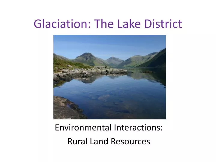
Glaciation: The Lake District. Environmental Interactions: Rural Land Resources. Topic Outline. Glacial Landforms 20 marker. Social, economic and environmental opportunities in the Lake District. Land use conflicts in the Lake District. Management of the Lake District. Aims of the lesson.

E N D
Glaciation: The Lake District Environmental Interactions: Rural Land Resources
Topic Outline • Glacial Landforms 20 marker. • Social, economic and environmental opportunities in the Lake District. • Land use conflicts in the Lake District. • Management of the Lake District.
Aims of the lesson • To practice answering 20 mark questions on upland glacial landforms.
Glacial Landforms Describe and explain, with the aid of annotated diagrams, the formation of the main features of glacial erosion in the Lake District or any other glaciated upland area which you have studied. 20 Marks Tips: • Landforms: • Corrie • Arete & Pyramidal Peak • U-Shaped Valley • Hanging Valley • Scree Slopes • Terminal moraine • 4 Marks awarded for named examples. • Detailed explanation of processes required. • 16 marks only if no diagrams included.
Processes of Glacial Erosion Freeze Thaw (Frost Shattering) Water in cracks in the rock freezes and expands. After many cycles of freezing and thawing lumps of rock are broken off. Plucking Glacier ice freezes into cracks in rocks and when the glacier moves it pulls out chunks to leave a jagged surface. Abrasion Rocks stuck in the ice grind away the bedrock under the glacier.
Glacial Landforms Describe and explain, with the aid of annotated diagrams, the formation of the main features of glacial erosion in the Lake District or any other glaciated upland area which you have studied. 20 Marks Tips: • Landforms: • Corrie • Arete & Pyramidal Peak • U-Shaped Valley • Hanging Valley • Scree Slopes • Terminal moraine • 4 Marks awarded for named examples. • Detailed explanation of processes required. • 16 marks only if no diagrams included.
Peer Marking Pass your finished 20 mark answer to another member of the class. Using a highlighter you will mark on the areas where you would give marks. Use the marking scheme provided and textbooks to help you. As bullet points, add in any information you feel they have missed out.
Homework Using the comments from other members of the class, repeat your glacial landforms 20 mark answer. Use the sample answer provided also.
Summary So far we have… • practiced answering 20 mark questions on upland glacial landforms.
Aims of the lesson • To learn about the location of the Lake District. • To learn about water supply in the Lake District.
Location of the Lake District Using the “Modern School Atlas” you are going to writer a brief description of the location of the Lake District It should include: • When it opened: 1951 • The name of a settlement within it: K_________ • The names of three cities nearby. • The names of the main roads connecting those cities to the Dales.
Location of the Lake District The Lake District National Park is situated in the North West of England. It is an area of spectacular glaciated scenery which is easily accessible via the M6 motorway from many large urban areas including the Manchester conurbation; Merseyside and Yorkshire. Major settlements in the Lake District are Keswick and Kendal.
Land Use in the Lake District The major land uses in the Lake District are: • Water Supply • Hill Sheep Farming • Tourism
Water Supply in the Lake District Lake Windermere
Suitability Why do you think water supply is a suitable land use in the Laker District? Think about: • Location • Number of lakes • Cost
Suitability Lakes have been providing water to Manchester for 100 years. Granite rock is impermeable. The lakes are cheaper than constructing reservoirs. There is plenty of water available (supplies 30% of regions water needs).
Review Questions Read p11 & 12 of the Intermediate textbook. Answer Qs 1,3,4,5.
Summary So far we have… • learnt about the location of the Lake District. • learnt about water supply in the Lake District. • Suitability • Conlfict
Aims of the lesson • To learn about the socialand economic opportunities in the Lake District.
Activity Dotted around the room are various fact cards on opportunities in the Lake District. Move around the room, taking at least 4 bullet points of notes at each station. Be ready to discuss why each social and economic opportunity is suitable in the Lake District.
Farming In upland areas many slopes are too steep for the use of large machinery and temperatures very low with a short growing season. Soils are thinner and rainfall heavy. It would be difficult to grow crops so Hill Sheep Farming is predominant with some beef cattle on lower and better land. The wool industry was very important in the past and sheep wool is still used for carpet making. Small farms used to be the principal employment in the Lake District but the umbers of farms has fallen significantly with land being sold for housing and tourism. Farmers now rely on EU subsidies and diversification for 80% of their income.
Forestry Large plantations are often seen – mainly because the land is poor and difficult to build on and forestry provides a profitable activity (which also provides leisure activities). The Forestry Commission has planted coniferous trees in many upland areas with over 75,000 tonnes of timber produced each year. The wood is mainly used as firewood and timber for housing. The forestry also creates new wildlife habitats, protecting the local environment. There are 53 full time jobs working for the Forestry Commission in the Lake District National Park.
Industry This ranges from mining and quarrying local stone to the main industry of tourism and recreation. Upland areas rarely attract factories and modern industries so extractive industries are more common. Slate is quarried in the Lake District from 10 quarries e.g. Kirkstone Slate near Ambleside.
Tourism This is one of the major employers in the Lake District and provides both social and economic opportunities. Increased car ownership and the opening of the M6 motorway means that 10 million people are within a 3 hour drive of the Lake District. Tourism has become important with the decline of traditional industries. It has helped keep some services like schools and shops in the local area and has brought leisure centres. Estimates suggest that in some areas e.g. Windermere more than 50% of the active population are employed in the tourist industry. Many other jobs are also supported indirectly through visitor spending e.g. bakers, builders and estate agents.
“With reference to Loch Lomond and the Trossachs or any other named upland area that you have studied, explain the social and economic opportunities create by the landscape.” 10 Marks Tips: • Name you case study area. • Explain the suitability of each land use: • Farming • Forestry • Industry • Water Supply • Tourism • Quote figures and give named examples.
Summary So far we have… • learnt about the social and economic opportunities in the Lake District: • Farming • Forestry • Industry • Water Supply • Tourism
Match Up Land Use Social & Economic Opportunity Farming Large quantities of slate, good road links for transport (M6). Forestry Large ribbon lakes. 30% of regions supply provided this way. Industry Land is too poor to grow crops. This is profitable. Water Supply 22 million visitors a year. 10 million within 3 hours. Tourism Thin soil, heavy rain, cold & steep slopes.
Aims of the lesson • To learn about conflict between land uses in the Lake District. • To learn about specific solutions to these conflicts in the Lake District.
Conflict Triangles In your groups, create a conflict triangle for each of the following land use conflicts: Farming V Tourism Forestry V Tourism Industry V Tourism Tourism V Tourism Use the handouts provided to help you. Effect Cause Solution
“Describe and explain the environmental conflicts that may occur in a named upland area you have studied (You should refer to named locations within your chosen landscape).” 10 Marks Tips: • Name your case study. • Identify a conflict e.g. tourists v farming. • Explain reasons why each of these land uses is in conflict. • Make reference to named examples.
Lake District National Park Authority Problem: Footpath Erosion Solutions: • Routes signposted. • Stones laid on footpaths. • Footpaths fenced off from fields. • New routes planned away from affected areas.
Lake District National Park Authority Problem: Litter & Vandalism Solutions: • Designated picnic areas with litter bins. • Park Wardens supervise and educate.
Lake District National Park Authority Problem: Cars parked on verges of narrow lanes. Solutions: • More car parks on ritter paving in Ambleside. • School premises used during summer holidays. • Yellow lines to prevent parking. • Park & Ride schemes. • One way systems.
“Describe specific solutions to environmental conflicts in a named upland area you have studied.” 10 Marks Tips: • Name your case study. • Identify a conflict e.g. tourists v farming. • Describe solutions to this specific conflict with reference to examples.
Summary So far we have… • learnt about conflict between land uses in the Lake District. • learnt about specific solutions to these conflicts in the Lake District.
Each year the National Park has more than 22 million visitors either on day trips or holidays. The area attracts a wide variety of visitors including those who want to visit the passive attractions like the picturesque villages to National Trust properties such as Hill Top the home of Beatrix Potter or Grasmere with its connections to Wordsworth. Others will prefer the active attractions on offer from sailing on the many lakes to walking the Lakeland Fells.