Download
1 / 1
10 likes | 170 Views
SNPP VIIRS green vegetation fraction products and application in numerical weather prediction. Zhangyan Jiang 1,2 , Weizhong Zheng 3,4 , Junchang Ju 1,2 , Marco Vargas 1 , Ivan Csiszar 1 , Michael Ek 4

E N D
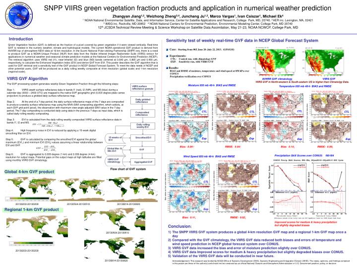
SNPP VIIRS green vegetation fraction products and application in numerical weather prediction Zhangyan Jiang1,2, Weizhong Zheng3,4, Junchang Ju1,2, Marco Vargas1, Ivan Csiszar1, Michael Ek4 1 NOAA National Environmental Satellite, Data, and Information Service, Center for Satellite Applications and Research, College Park, MD, 20740. 2 AER inc. Lexington, MA, 02421 3 IMSG inc. Rockville, MD 20852 4 NOAA National Centers for Environmental Prediction, Environmental Modeling Center, College Park, MD 20740 12th JCSDA Technical Review Meeting & Science Workshop on Satellite Data Assimilation, May 21-23, NOAA NCWCP, College Park, MD Introduction Green Vegetation fraction (GVF) is defined as the fraction of a pixel covered by green vegetation if it were viewed vertically. Real-time GVF is needed in the numeric weather, climate and hydrological models. The current NOAA operational GVF product is derived from AVHRR top of atmosphere NDVI data at 16-km resolution. In the Suomi National Polar-orbiting Partnership (SNPP) era, there is a need to produce GVF as a NOAA-Unique Product (NUP) from data from the Visible Infrared Imager Radiometer Suite (VIIRS) sensor for applications in numerical weather and seasonal climate prediction models at the National Centers for Environmental Prediction (NCEP). The retrieval algorithm uses VIIRS red (I1), near-infrared (I2) and blue (M3) bands centered at 0.640 μm, 0.865 μm and 0.490 μm, respectively, to calculate the Enhanced Vegetation Index (EVI) and derive GVF from EVI. This poster describes the GVF algorithm that is used for GVF retrieval and a sensitivity test of the GVF product in NCEP Global Forecast System. To meet the data needs of NCEP and other potential users, GVF will be produced as a daily rolling weekly composite at 4-km resolution (global scale) and 1-km resolution (regional scale). • Sensitivity test of weekly real-time GVF data in NCEP Global Forecast System • Case: Starting from 00Z June 20–July 22, 2013. (GFS/GSI) • Experiments: • CTL: Control run, with climatology GVF • EXP: Sensitivity run, with VIIRS GVF • Results: • BIAS and RMSE of moisture, temperature and wind speed at 850 hPa over • CONUS • Precipitation verification over CONUS VIIRS GVF Algorithm AVHRR GVF climatology VIIRS GVF VIIRS GVF in North-western & South-eastern US is higher than Climatolgy Data. The GVF processing system generates weekly Green Vegetation Fraction through the following steps: Step 1: VIIRS swath surface reflectance data in bands I1 (red), I2 (NIR), and M3 (blue) during a calendar day (0000 – 2400 UTC) are mapped to the native GVF geographic grid (0.003 degree plate carree projection) to produce a gridded daily surface reflectance map. Step 2: At the end of a 7-day period, the daily surface reflectance maps of the 7 days are composited to produce a weekly surface reflectance map using the MVA-SAVI compositing algorithm, which selects, at each GVF grid point (pixel), the observation with maximum view-angle adjusted SAVI value in the 7-day period. The 7-day compositing is conducted daily using data in the previous 7 days as input data, which is called daily rolling weekly compositing. Step 3: EVI is calculated from the daily rolling weekly composited VIIRS surface reflectance data in bands I1, I2 and M3. Moisture 850 mb 48-h BIAS and RMSE Temperature 850 mb 48-h BIAS and RMSE CTL CTL CTL CTL Step 4: High frequency noise in EVI is reduced by applying a 15-week digital smoothing filter on EVI. Step 5: GVF is calculated by comparing the smoothed EVI against the global maximum (EVI∞) and minimum EVI (EVI0) values assuming a linear relationship between EVI and GVF. Step 6: GVF is aggregated to 0.009 degree (1-km) and 0.036 degree (4-km) resolution for output maps. Potential gaps on the output maps at high latitudes are filled using monthly VIIRS GVF climatology. Exp Exp Exp Exp Bias: 0.09 ↑ RMSE: 0.04↑ Bias: 0.14↓ RMSE: 0.09↓ Wind Speed 850 mb 48-h BIAS and RMSE Precipitation Skill Scores over CONUS: f60-f84 Flow chart of GVF system Global 4-km GVF product CTL CTL 20130203-20130209 20130504-20130510 20130814-20130820 Regional 1-km GVF product Exp Exp Bias: 0.11↓ RMSE: 0.02↓ Improved scores for medium & heavy precipitation but slightly degraded biases Conclusion: The SNPP VIIRS GVF system produces a global 4-km resolution GVF map and a regional 1-km GVF map once a day Compared with the GVF climatology, the VIIRS GVF data reduced both biases and errors of temperature and wind speed prediction in NCEP global forecast system over CONUS. VIIRS GVF data increased the bias and error of moisture prediction slightly over CONUS. VIIRS GVF data Improved scores for medium & heavy precipitation but slightly degraded biases over CONUS. Validation of the VIIRS GVF data will be conducted in near future. 20130504-20130510 20130203-20130209 20130814-20130820 Acknowledgement: This research was funded by NOAA Office of Systems Development (OSD), Systems Engineering and Integration Division (SEID). The views, opinions, and findings contained in this poster are those of the author(s) and should not be construed as an official National Oceanic and Atmospheric Administration or U.S. Government position, policy, or decision