Download
1 / 19
240 likes | 858 Views
Name, Location, Climate, Landforms, and Regions of Pennsylvania. Lesson 1 & 2. 5 Themes of Geography. 1. L ocation – location of city or your community 2. P lace – where something is in relation to its surroundings ex. City in contrast to smaller communities

E N D
Name, Location, Climate, Landforms, and Regions of Pennsylvania Lesson 1 & 2
5 Themes of Geography • 1. Location – location of city or your community • 2. Place – where something is in relation to its surroundings ex. City in contrast to smaller communities • 3. Human-Environment Interaction – how people depend on the environment or change land • 4. Movement – connection between places and patterns of movement • 5. Region – ex. Tourist, political, business, rural, urban, suburban, or even school district
1681 – name of state provided by William Penn and the King of England. • Penn wanted to call colony “Sylvania” (woods) • King added Penn in honor of William’s father • Penn’s woods • Commonwealth– • Pennsylvania is one of only four states that carry title – Massachusetts, Virginia, and Kentucky
Location • Pennsylvania is 45,333 square miles • Square mile – • 302 miles wide and 158 miles length • Panhandle –
Climate • Humid continental – • Adequate rainfall and is suitable for farming • Average temperatures • July – 76 ̊ in southeast, 68 ̊ along Lake Erie • December – 31 ̊ in southeast, 24 ̊ along Lake Erie • Record high – 111 ̊ Record low - -42 ̊
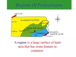
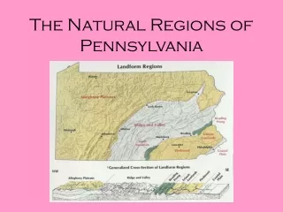
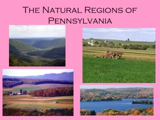
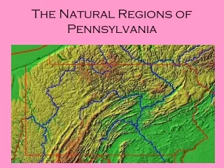
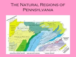
Landforms and Regions • 5 distinctive geographic regions • Regions – • Each region has common landforms and elevations • Landform –
Atlantic Coastal Plain • Along Eastern Coast of United States • Elevation ranges from 26 feet above sea level to sea level • Contains the city of Philadelphia
Piedmont • Southeast region between Philadelphia and Harrisburg • Reaches elevation of 600 feet above sea level • Includes some of the most fertile soil in the United States • Allentown, Reading, Lancaster, York • Farms, fields, and forests
Ridge and Valley • Hills – • Ridges – • Valleys – • Contains the Appalachian Mountains – mountain chain that runs from Georgia to Maine • Ridges and valleys have individual names
Mt. Davis – state’s highest elevation at 3,213 feet above sea level, located in southern Somerset County • Pennsylvania mountains are low in elevation to other parts of the country
Allegheny Plateau • Covers 60% of Pennsylvania • Plateau – • Elevations range from 700 to 2,500 feet • Pocono Mountains – formed by glacial forces
Erie Plain • Northwest corner of state along Lake Erie • Only 4 miles wide, stretching from shoreline • Soil is rich in sand and silt • Erie – Pennsylvania’s third largest city