Download
1 / 16
160 likes | 313 Views
Work on your own data (graduate or senior project) Tundra fire regimes (Dr. Higuera) Fine scale habitat maps (Ginny Harris) Develop additional questions using class data. Final Project - Many choices!. Final Project Proposal (optional). Introduction Objectives or Hyporhesis

E N D
Work on your own data (graduate or senior project) • Tundra fire regimes (Dr. Higuera) • Fine scale habitat maps (Ginny Harris) • Develop additional questions using class data Final Project - Many choices!
Final Project Proposal (optional) • Introduction • Objectives or Hyporhesis • Data and data sources • Proposed methods • Expected outputs/results Include the following (max 3 pages): Grading rubrik on REM402 web site
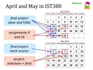
Final Project AlternativesREM402, Fall 2010 Timeline • Submit proposal (optional) Oct 11 the latest • Work on project during Friday lab time Oct 15 (Eva in Boise), 22, 29 • …also lecture time Oct 18-29 • You are expected to spend some time outside of class hours on the project • Final due date Nov 15 Grading rubrik on REM402 web site
Tundra Fire Regimes in Alaska: many questions…few answers Photo: Dale Woitas, AFS, BLM
Shrub expansion: AK Fire Service, BLM • Will tundra area burned increase? Photo: Dale Woitas, AFS, BLM W. Chapman , U of IL: http://arctic.atmos.uiuc.edu/CLIMATESUMMARY/2003
Some basic questions: • Are tundra fires biased towards specific vegetation types, and/or specific topographic conditions or landforms? • What climatic conditions are associated with historic tundra fires? • How to large vs. small tundra fire differ in terms of these patterns? • How do tundra fires differ from boreal forest fires (e.g. fire size)?
Existing, rich, data sources: Alaska Fire Database: historic fires from 1950 to present, including record-setting Anaktuvuk River Fire of 2007 (http://agdc.usgs.gov/data/blm/fire/index.html) Circumpolar Arctic Vegetation Map (CAVM): tundra vegetation across Alaska and the Arctic (http://www.geobotany.uaf.edu/cavm/ ) LANDFIRE: vegetation composition and structure, specific for fire and resource management (http://landfire.cr.usgs.gov/viewer/)
Alaska fire history (red polygons) + CAVM vegetation classes: • Non-random locations implies a biophysical explanation
Example analyses: Overlay Analysis: Do different tundra types burn more or less than expected based on random? Expected area burned Observed area burned Tundra vegetation types
Example analyses: Overlay Analysis: what are the climatic conditions where most tundra fire occur? Undergraduate student in GIS class
Contact: Philip Higuera Assistant Professor of Fire Ecology phiguera@uidaho.edu
GAP Habitat Model Predicted suitable habitat for the Greater Sage Grouse Focus on Sagebrush Habitats
Objective 1So many maps…..so little time… • Develop wildlife habitat models using the vegetation layer produced by GAP (30 m) and regionally derived finer scale map products (e.g. 3 m resolution and finer thematic resolution, e.g. shrub cover classes).
Compare the accuracy of wildlife habitat models for selected vertebrate species ranging from generalists to specialists using the 30 m and 3 m maps and different thematic resolution. • Develop recommendations for biological traits that should be considered when selecting the mapping scale. Objective 2Model Accuracy
What map products and other GIS data are useful for conservation planning and development of CCA’s in sagebrush steppe? • Develop guidelines, describing how GAP principles can be applied to regional map products to derive habitat models that are suitable for local conservation planning. • Maps and models developed in this project will • be available to those interested in conservation • planning in the region where the prototype data • was produced. Objective 3Applications in Local Conservation Planning
OpportunitiesDevelop GIS databases Candidate Conservation Agreements • Fine scale vegetation maps with sage cover classes • Gather other GIS data • Elevation • Parcels • Roads • Streams • Fire atlas data • Wells • …….what else?