Download
1 / 32
370 likes | 638 Views
Geology and environmental change. Peter Whiteside & Isabel Fernandez EFG- coordinator EIA panel of experts EFG office director. The role of geology in Environmental Impact Assessments (EIAs) The role of geology in predicting future climate change.

E N D
Geology and environmental change Peter Whiteside & Isabel Fernandez EFG-coordinator EIA panel of experts EFG office director
The role of geology in Environmental Impact Assessments (EIAs) • The role of geology in predicting future climate change
The role of geology in Environmental Impact Assessments (EIAs)
The role of geology in Environmental Impact Assessments (EIAs) The EIA Process – main stages Screening Scoping Studies Monitoring & audit Is an EIA required ? What should the EIA cover ? Study of impacts Verification of predictions
The role of geology in Environmental Impact Assessments (EIAs) Geological perspective on the environment Geological Processes eg mountain building, erosion & deposition Physical Environment eg hillslopes, floodplains, rivers, estuaries, sea Habitat - Ecosystem eg forests, grasslands, wetlands, beaches, seabed, coral reefs
The role of geology in Environmental Impact Assessments (EIAs) Examples of geological information used in EIAs • Geological maps • Site inspection • Records of mining and quarrying • Records of groundwater extraction • Existing borehole records • Aerial photos • Seismic records
Examples of important geological factors in EIAs • Risk to peopleand property Landslides, earthquakes, radon from bedrock, undermining, eroding coasts • Soils Peat/Fens, beaches, cultivated topsoils • Water Aquifers, karst areas, rivers, lakes, estuaries, seas • Landscape features Mountains ranges, gorges / valleys, waterfalls, sea shore & cliffs, caves • Natural materials Rock & minerals above and below ground, marine sand & gravel • Cultural heritage Sites of special scientific interest, archaeological sites including mining
The role of geology in Environmental Impact Assessments (EIAs) Examples of the role of geology in EIAs and related studies • Sustainable use of groundwater – FINLAND • Contamination in groundwater – ITALY • Environmental geological map - HUNGARY
FINLAND • Sustainable use of groundwater :- • Computer modeling • Planned extraction rate • Aquifers can recharge • Ecosystems not affected • Monitor to check predictions
The role of geology in Environmental Impact Assessments (EIAs) • Sustainable use of groundwater : • Computer modeling • Planned extraction rate • Aquifers can recharge • Ecosystems not affected • Monitor to check predictions
Modeling approach Groundwater flow model
The role of geology in Environmental Impact Assessments (EIAs) ITALY Predicting contamination changes in groundwater • Years of chemical pollution from industrial site • Complex geology and hydrogeology • Computer modeling of groundwater flow • Predictions of contamination levels • Remedial design
ITALY Conceptual model of groundwater flow
ITALY Groundwater flow model
The role of geology in Environmental Impact Assessments (EIAs) • Environmental geological map • Collect field data, boreholes, etc • Collect data on mining, waste disposal, groundwater • Make digital maps with a GIS • Land-use planning, for water supply, quarrying, etc
Example of digital map data
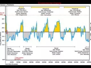
The role of geology in predicting future climate change Geological records of past climate • Climate evidence preserved throughout the geological past • Important to distinguish between natural and man-made changes • Recent geological past helps understand natural climate changes • Sea-level rose 120 metres during global warming from 18000 to 6000 years ago • Climate relatively stable since 6000 years ago but natural changes in temperature continue to the present-day
The role of geology in predicting future climate change Examples of geological indicators of climate change • Sediments and ice cores give indications of past climate : • Pollen and organic content temperature and precipitation. • Layered clays in lakes erosion & deposition precipitation & temperature. • The remains of animal species climate. • Ratio of oxygen isotopes continuous measure of temperature. • Computer models help in predicting future changes.
The role of geology in predicting future climate change Examples of geological studies which record climate changes • Evidence of sea-level changes from marine sediments – BELGIUM • Reconstruction of past climates : Clues to the future – SWEDEN • South Atlantic island sediments show details of past climate – SWEDEN • Climate change in the alpine region - SWITZERLAND
The role of geology in predicting future climate change • Seismic surveys show pattern of marine sediments • Deposition & erosion linked to global sea-level changes • Sediment deposited 120,000 years ago : sea-level like today • Sediment eroded during ice age : sea-level lower than today • Today, new sediments deposited and form tidal sandbanks.
Seismic surveys to study the pattern of sediments below the seabed
Present day water depth showing tidal sandbanks (Red is shallow and blue is deep)
The role of geology in predicting future climate change • Sediment core information about the past • Pollen & organic remains climate information • Grasses & tree type temperature & precipitation
Lake sediments on island in south Atlantic analysed • Sediments indicate • major warm phase at 8700 years ago • periods of higher temperature and rain since then • Warm periods correspond to cool periods in north Atlantic • Temperature contrasts due to changes of oceanic currents • Computer models agree with the sediment data
South Atlantic was warmer Model results for sea surface temperature about 8000 years ago
South Atlantic was wetter Model results for precipitation about 8000 years ago
The role of geology in predicting future climate change • Climate warming documented in the Alpine region using • magnitude and frequency of extreme rainfall • mean elevation of zero temperature • historical records • Melting & freezing cycles and loss of permafrost zone cause • Rock and debris flows which are a major threats • Example : 30 million cubic metres event in Randa, 1991
Geology and environmental change The EFG would like to thank you for your attention