Download
1 / 8
80 likes | 199 Views
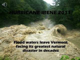
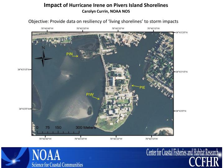
Impact of Hurricane Irene on Pivers Island Shorelines Carolyn Currin, NOAA NOS. Objective: Provide data on resiliency of ‘living shorelines’ to storm impacts. Installed 6 horizon makers at each PI site, at lower, middle and upper edge Read SETS at PIW (Sill) and PIN (NAT) post –storm

E N D
Impact of Hurricane Irene on Pivers Island Shorelines Carolyn Currin, NOAA NOS Objective: Provide data on resiliency of ‘living shorelines’ to storm impacts
Installed 6 horizon makers at each PI site, at lower, middle and upper edge • Read SETS at PIW (Sill) and PIN (NAT) post –storm • Examined hardened structures for evidence of erosion PIW marsh-sill PIE marsh-oyster restoration
NOAA NWLON station 8656483 Wind speed (mph)
Sediment accretion in Pivers Island Marshes Hurricane Irene resulted in net sediment deposition to PI sites
Erosion behind west-facing bulkhead (consistent with R. Gittman assessment of stabilization structures in Bogue Sound) Erosion of bank behind riprap Minimal erosion of unvegetated sediment bank Intact upland border adjacent to marsh
Additional data on Hurricane Irene impacts to estuarine shorelines Carteret Co. marsh width vs. wave energy 20 yr old Oyster reef – marsh project ‘Dredge Island’ Dredge Island wave exposure setting Salt marsh October 2011 post-Irene Conclusion: Marsh – oyster reefs provide an effective shoreline stabilization alternative South shore of Dredge Island restoration site
Two other assessments : J. Fear NERRS: marsh sill projects -little damage, wrack deposition -ome adjacent erosion of shoreline R. Gittman UNC: bulkheads, sills, marshes in Bogue & APES -bulkhead erosion more prevalent than marsh erosion
Summary of observations on Irene impact on shoreline stabilization projects Sill structures showed no damage with marsh intact Some accumulation and sediment trapping by larger structures. Design matters. Bulkheads and upland revetments showed some damage and scour – often overtopped. Slope is important. Unvegetated sediment banks eroded Intact marsh-upland boundaries showed no upland erosion or marsh loss. Oyster reef-marsh shorelines showed no erosion. We documented net sediment gain in Pivers Island shoreline marshes. Pivers Island transplanted marsh Oyster cultch addition DMF