Download
1 / 26
260 likes | 373 Views
Status and Future of GPCP and TRMM. Robert Adler Laboratory for Atmospheres/NASA Goddard. Tropical Rainfall Measuring Mission (TRMM).

E N D
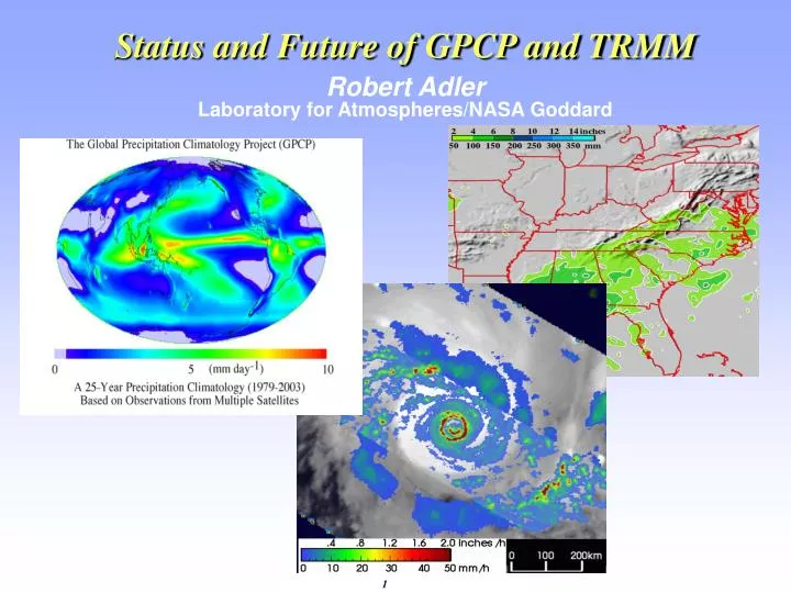
Status and Future of GPCP and TRMM Robert Adler Laboratory for Atmospheres/NASA Goddard
Tropical Rainfall Measuring Mission (TRMM) • Science Objective: Advance knowledge of global water and energy cycles through observed time and space distributions of tropical rainfall, hydrometeor structure and latent heating. • Approach: Accurate estimation of precipitation characteristics through first-time use of passive and active microwave instruments. • NASA/JAXAJoint mission launched in Nov. 1997 into inclined (35º) orbit; spacecraft and instruments in excellent condition • Program: NASA’s Precipitation Measurement Missions (PMM); PMM science team covers TRMM and GPM • Instrument Payload: • TRMM Microwave Imager (TMI) • 10, 19, 37, 86 GHz, conical scanning • Precipitation Radar (PR) [Japan] • 14 GHz, cross-track scanning • Lightning Imaging Sensor (LIS) [MSFC] • Staring optical array • Visible IR Scanner (VIRS) • 5-channel, cross-track scanning • Cloud & Radiant Energy System (CERES) [LRC] • Radiation budget (failed after 6 mos.)
First TRMM Science Workshop--1986 First Report--1988 1986-2006: Twenty years of TRMM!
Space standard for measuring precipitation Improved climatology of tropical rainfall and variations Convection intensity observations and variations Climatology of lightning over land and ocean Vertical heating structure and diurnal variations Improved climate and weather modeling Impact of humans on precipitation Hurricane/typhoon structure/evolution Multi-satellite (~3-hr) rainfall analyses using TRMM+other satellites Flood and agricultural applications Operational use of data by weather agencies. Major Science Results Tropical Rainfall Measuring Mission (TRMM) Senior Review Proposal
Tropical Rainfall Measuring Mission (TRMM) Eight-Year TRMM Climatology January 1998 - December 2005 TRMM Multi-satellite product (TMPA--3B43)
TRMM reduces uncertainties in tropical ocean rainfall to ~5%
Tropical Rainfall Measuring Mission (TRMM) Diurnal Cycle of TRMM Precipitation Features Comprehensive Global Census of Rain Events Reveals Different Timing, Character of Rain Maxima Over Land vs. Water Oceans Continents 1.Rain max from features over the ocean is due only to an increase in their number in the early morning. 2. The broad overnight continental MCS rainfall max results from decreasing numbers and increasing areas. 3. Continental features peak in number and conditional rain rate during the afternoon: this dominates the higher amplitude diurnal cycle over land. Zipser
TRMM - Derived 3D Latent Heating Distribution Latent heating in convective and stratiform clouds drives the tropical Hadley Cell - plays crucial role in poleward heat transport by Earth’s atmospheric and oceanic fluid system. A primary mission objective of TRMM is to quantify the 4D distribution of tropical latent heat release. Accurate estimates of heating are crucial for climate models and their cumulus parameterization schemes. Areas of largest rain rates map to the greatest in-cloud heating. Annual average latent heating is maximized across the Pacific, over the Maritime Continent, and is largest at high altitudes (~ 8 km). Tao
Impact of Humans on Precipitation Impact of Cities on Rainfall Effect of Pollution on Rainfall Over Ocean 1 3 2 Houston downwind rainfall maximum (Shepherd) Lack of PR-detected rain in polluted clouds (Rosenfeld) Pollution Impact on Land Rainfall Increase in Summer Rain over SE U.S. during week (red curve)--Increase offshore on weekend (blue curve)--(Bell)
TRMM Data Used for Hurricane/Typhoon Monitoring TRMM TMI data used by NOAA and DoD (and int’l agencies) for tropical cyclone detection, location and intensity estimation--600 TRMM-based tropical cyclone “fixes” in 2004 TRMM orbit advantageous for tropical cyclone monitoring--despite narrow swath it is always in tropics, sampling about same as one SSM/I over all tropics, but TRMM sampling best in 10-35º latitude storm band. TMI resolution twice as good as SSM/I, about same as AMSR. Precessing orbit provides off-time observations relative to sun-synchronous microwave observations. Hurricane Katrina TRMM image from NRL Tropical Cyclone web site TRMM radar (PR) cross-sections of hurricanes available in real-time for operational analysis from TRMM web site--potential for PR use not realized at this point--data readily available from TRMM web site
TRMM Calibrating Other Satellites in TRMM Multi-satellite Precipitation Analysis (TMPA) (3 hr) Combined “high quality” (conical scanning) microwave data coverage: Averages 55% with TRMM, AMSR-E and 3 SSM/I’s Addition of 3 AMSU-B’s (lower quality over ocean): Total coverage averages ~ 85% Remaining gaps filled by Geo-IR precipitation estimates Version 6 3B42: Eight year, 3-hr data set
Use TMPA for Analysis of Extreme Precipitation Events Largest Daily Rainfall Over 8-year Period
Science with an Extended TRMM Mission (2006-2012?) (from Senior Review proposal) • An improved climatology of precipitation characteristics, especially extremes • Improved diagnosis and closure of global (and regional) water cycles • Diagnosis and testing of inter-decadal and trend-related processes in the water cycle • Assessment of impact of humans (e.g., cities and aerosols) on rainfall characteristics and processes • Robust determination of convective system, tropical cyclone and lightning characteristics • Advances in hydrological applications over land on basin and continental scales • Improved modeling of global water/energy cycles for weather/climate predictions • Improved monitoring and forecasting of tropical cyclones, floods and other hazardous weather Unique opportunity to obtain combined active and passive observations of clouds, aerosols, and precipitation with “A-Train”--Cloudsat, CALIPSO, Aqua--and TRMM
TRMM--Past, Present, Future • TRMM Experimental Phase (Jan. 1998-August 2001[~3.5 years]). 350 km altitude. (better PR sensitivity) • TRMM Extended Phase (August 2001-present). 402 km altitude. (reduced PR sensitivity[5+ years]). Fuel sufficient to ~2012 • Version 6 TRMM products improved, but impact of boost evident; Version 7 (~2008) will address boost issue and transition toward GPM era • TRMM (with radar and passive microwave in inclined orbit) is now key to calibrating polar orbiting passive microwave satellites (currently Aqua/AMSR, 3 DMSP/SSM/I’s, 3 NOAA/AMSU’s) and GeoIR satellites, allowing for development of high time resolution precipitation information. • TRMM extension decision allows for continuation of TRMM-based science and applications, up to and (hopefully) overlapping GPM core (also at ~400 km altitude). • GPM will add critical microphysical information, expand latitude range to middle and high latitudes, provide improved microwave sampling, and lengthen important radar/radiometer record started by TRMM.
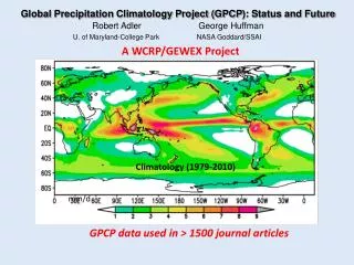
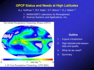
Global Precipitation Climatology Project (GPCP) A GEWEX Global Data Project under World Climate Research Program (WCRP) http://lwf.ncdc.noaa.gov/oa/wmo/wdcamet-ncdc.html http://precip.gsfc.nasa.gov
Development and production of long-term, global precipitation analyses at monthly and finer time scales for use in studies of weather and climate variations Evaluation and characterization of quality of estimates for various applications Improving the analyses through incorporation of new data, improved analysis techniques, etc. Analysis of the data sets--precipitation alone or in combination with other components of the hydrological cycle GPCP Objectives
GPCP Global Precipitation Products NASA, NOAA, DWD, Universities, JMA, EUMETSAT • Monthly, 2.5° Merged Analysis (1979-present) Adler et al. (2003), J. Hydromet. • Pentad, 2.5° Merged Analysis (1979-present) Xie et al. (2003) J. Climate • Daily, 1° Merged Analysis (1997-present) Huffman et al. (2001) J. Hydromet. [although produced using different data sets and algorithms, products are integrated,i.e. they add up] produced ~ 3 months after observation time “GPCP” in title or abstract of 58 journal papers; product reference papers cited over 500 times
Merge Center--Adler/Huffman, NASA Goddard Gauge Center--Fuchs/Schneider, German Weather Service, Global Precipitation Climatology Center (GPCC) Microwave-Land Center--Ferraro, NOAA NESDIS Microwave-Ocean Center--Chiu, George Mason U./NASA Goddard Geosynchronous Center--Janowiak/Xie, NOAA/NWS/CPC (also do pentad merge and supplemental gauge input) Additional satellite data and data processing provided by JMA and EUMETSAT GPCP Assessment--Gruber/Levizzani GPCP Components/People
Variations in Global Precipitation (1979-2005) Little or no linear change during period--ocean and land precipitation tend to compensate Pattern of Linear change (1979-2005)
Tropical Rainfall Variations (ENSO, volcanoes, long-term change) Original Monthly Series Derived ENSO ocean and land signals Derived volcano impact-up to 5% Derived data set with ENSO and volcanic signals “removed”-note reduced amplitude of variations Figure from Gu et al. (2006)
Time Series of Annual Totals (Tropics) 2005-largest annual tropical rainfall in series Linear positive change 5% over ocean and 3% over ocean/land combined--statistically significant at ≥ 99%. May indicate long-term precipitation change signal. Additional analysis is ongoing. Figure from Gu et al. (2006)
Current merge approach and bias errors in gauge analysis in mountains leads to underestimation in these areas--noted by hydrologists Currently TRMM, AMSR and AMSU data not included Data boundaries at1986 (gauge analysis shift, geosynchronous data start) and July 1987 (OLR/OPI-geo to SSM/I shift) Issues with Current Products
Possible use of new GPCC (German Weather Service) 50-year gauge analysis as base gauge analysis (would eliminate gauge data boundary at 1986) Possible “quick-look” monthly product shortly after end of month for use in climate monitoring Possible ororaphy adjustment as a function of altitude/climate regime Product Plans (Short-term [2006-2007]) These changes would be incorporated in a Version 2.1 and will be one focus at working group meeting in Nov.
Possible Improvements in new analyses: Coordinated analysis methods and input data sets across time resolutions and record length (1979--present) Minimization of data set time boundaries, (or other) boundaries Higher time and space resolutions (~ 3 hr, 25 km) for part of the period (e.g., 1998-present)--possible community approach New passive microwave algorithm (s), new passive microwave data (AMSR, TRMM, AMSU); use of TRMM radar for calibration; use of daily gauges Integration of high time/space resolution period with longer period with coarser time/space resolution Rain/snow discrimination (probably by temperature) Goal is to have Version 3/Re-processing plan early in 2007 that results in community processing effort GPCP Product Plans (Version 3/Reprocessing)
TRMM BAMS article Simpson, Adler and North (1988) March 1988--9 years before launch!