Download
1 / 30
520 likes | 1.24k Views
Ground Water. Prepared by Betsy Conklin for Dr. Isiorho. Ground Water. ground water: the water that lies beneath the ground surface, filling the pore space between grains in bodies of sediment and clastic sedimentary rock, and filling cracks and crevices in all types of rock

E N D
Ground Water Prepared by Betsy Conklin for Dr. Isiorho
Ground Water • ground water: the water that lies beneath the ground surface, filling the pore space between grains in bodies of sediment and clastic sedimentary rock, and filling cracks and crevices in all types of rock • ground water is a major economic resource, particularly in the dry western areas of the US and Canada • source of ground water is rain and snow that falls to the ground a portion of which percolates down into the ground to become ground water
Porosity and Permeability • porosity: the percentage of rock or sediment that consists of voids or openings • permeability: the capacity of a rock to transmit a fluid such as water or petroleum through pores and fractures • porous: a rock that holds much water • permeable: a rock that allows water to flow easily through it • impermeable: a rock that does not allow water to flow through it easily
The Water Table • saturated zone: the subsurface zone in which all rock openings are filled with water • water table: the upper surface of the zone of saturation • vadose zone: a subsurface zone in which rock openings are generally unsaturated and filled partly with air and partly with water; above the saturated zone • capillary fringe: a transition zone with higher moisture content at the base of the vadose zone just above the water table
The Water Table (cont.) • perched water table: the top of a body of ground water separated from the main water table beneath it by a zone that is not saturated
The Movement of Ground Water • most ground water moves relatively slowly through rock underground • because it moves in response to differences in water pressure and elevation, water within the upper part of the saturated zone tends to move downward following the slope of the water table Movement of ground water beneath a sloping water table in uniformly permeable rock. Near the surface the ground water tends to flow parallel to the sloping water table
Movement of Ground Water (cont.) • factors affecting the flow of ground water: • the slope of the water table - the steeper the water table, the faster ground water moves • permeability - if rock pores are small and poorly connected, water moves slowly; when openings are large and well connected, the flow of water is more rapid
Aquifers • aquifer: a body of saturated rock or sediment through which water can move easily • good aquifers include sandstone, conglomerate, well-joined limestone, bodies of sand and gravel, and some fragmental or fractured volcanic rocks such as columnar basalt • aquitards: when the porosity of a rock is 1% or less and therefore retards the flow of ground water
Aquifers (cont.) • unconfined aquifer: a partially filed aquifer exposed to the land surface and marked by a rising and falling water table • confined aquifer (artesian aquifer): an aquifer completely filled with pressurized water and separated from the land surface by a relatively impermeable confining bed, such as shale
Wells • well: a deep hole, generally cylindrical, that is dug of drilled into the ground to penetrate an aquifer within the saturated zone • recharge: the addition of new water to the saturated zone • the water table in an unconfined aquifer rises in wet seasons and falls in dry seasons as water drains out of the saturated zone into rivers Wet season: water table and rivers are high; springs and wells flow readily Dry season: water table and rivers are low; some springs and wells dry up
Wells (cont.) • cone of depression: a depression of the water table formed around a well when water is pumped out; it is shaped like an inverted cone • drawdown: the lowering of the water table near a pumped well Pumping well lowers the water table into a cone of depression
Wells (cont.) • artesian well: a well in which water rises above the aquifer Artesian well spouts water above land surface in South Dakota, early 1900s. Heave use of this aquifer has reduced water pressure so much that spouts do not occur today
Springs and Streams • spring: a place where water flows naturally from rock onto the land surface • some springs discharge where the water table intersects the land surface, but they also occur where water flows out from caverns or along fractures, faults, or rock contacts that come to the surface Water enters caves along joints in limestone and exits as springs at the mouths of caves Springs can form along faults when permeable rock has been moved against less permeable rock. Arrows show relative motion along fault Water moves along fractures in crystalline rock and forms springs where the fractures intersect the land surface Springs form at the contact between a permeable rock such as sandstone and an underlying less permeable rock such as shale
Springs and Streams (cont.) • gaining stream: a stream that receives water from the zone of saturation • losing stream: a stream that looses water to the zone of saturation Water table can be close to the land surface beneath a dry stream bed Stream gaining water from saturated zone Stream losing water through stream bed to saturated zone
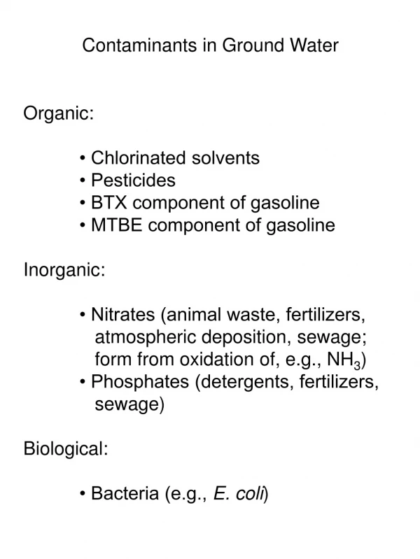
Pollution of Ground Water • pesticides, herbicides, fertilizers: chemicals that are applied to agricultural crops that can find their way into ground water when rain or irrigation water leaches the poisons downward into the soil • rain can also leach pollutants from city dumps into ground-water supplies • Heavy metals such as mercury, lead, chromium, copper, and cadmium, together with household chemicals and poisons, can all be concentrated in ground-water supplies beneath dumps
Pollution of Ground Water (cont.) • liquid and solid wastes from septic tanks, sewage plants, and animal feedlots and slaughterhouses may contain bacteria, viruses, and parasites that can contaminate ground water • acid mine drainage from coal and metal mines can contaminate both surface and ground water • radioactive waste can cause the pollution of ground water due to the shallow burial of low-level solid and liquid radioactive wastes from the nuclear power industry
Pollution of Ground Water (cont.) • pumping wells can cause or aggravate ground-water pollution Water table steepens near a dump, increasing the velocity of ground-water flow and drawing pollutants into a well Water-table slope is reversed by pumping, changing direction of the ground-water flow, and polluting the well
Balancing Withdrawal and Recharge • a local supply of groundwater will last indefinitely if it is withdrawn for use at a rate equal to or less than the rate of recharge to the aquifer • if ground water is withdrawn faster than it is being recharged, however, the supply is being reduced and will one day be gone
Balancing Withdrawal and Recharge • heavy use of ground water can result in: • a regional water table dropping • deepening of a well which means more electricity is needed to pump the water to the surface • the ground surface settling because the water no longer supports the rock and sediment Subsidence of the land surface caused by the extraction of ground water, near Mendota, San Joaquin Valley, CA. Signs on the pole indicate the positions of the land surface in 1925, 1955, and 1977. The land sank 30 feet in 52 years.
Balancing Withdrawal and Recharge (cont.) • to avoid the problems of falling water tables, subsidence, and compaction, many towns use artificial recharge to increase recharge; natural floodwaters or treated industrial or domestic wastewaters are stored in infiltration ponds in the surface to increase the rate of water percolation into the ground
Effects of Ground-Water Action • caves (or caverns): naturally formed underground chamber • most caves develop when slightly acidic ground water dissolves limestone along joints and bedding planes, opening up cavern systems as calcite is carried away in solution • most caves probably are formed by ground water circulating below the water table H2O + CO2 + CaCO3 Ca++ + 2HCO3- carbon dioxide calcite in limestone calcium ion bicarbonate ion water development of caves (solution) development of flowstone and dripstone (precipitation)
Effects of Ground-Water Action (cont.) • stalactites: icicle-like pendants of dripstone hanging from cave ceilings, generally slender and are commonly aligned along cracks in the ceiling, which act as conduits for ground water • stalagmites: cone-shaped masses of drip-stone formed on cave floors, generally directly below stalactites Water moves along fractures and bedding planes in limestone, dissolving the limestone to form caves below the water table Falling water table allows cave system, now greatly enlarged, to fill with air. Calcite precipitation forms stalactites, stalagmites, and columns above the water table
Effects of Ground-Water Action (cont.) • sinkholes: closed depressions found on land surfaces underlain by limestone; they form either by the collapse of a cave roof or by solution as descending water enlarges a crack in limestone A collapse sinkhole that formed suddenly in Winter Park, Florida, in 1981 Trees grow in a sinkhole formed in limestone near Mammoth Cave, Kentucky
Effects of Ground-Water Action (cont.) • karst topography: an area with many sinkholes and with cave systems beneath the land surface Karst topography is marked by underground caves and numerous surface sinkholes. A major river may cross the region, but small surface streams generally disappear down sinkholes
Effects of Ground-Water Action (cont.) • petrified wood: develops when porous buried wood is either filled in or replaced by inorganic silica carried in by ground water • concentration: a hard, round mass that develops when a considerable amount of cementing material precipitates locally in a rock, often around an organic nucleus • geodes: partly hollow, globe-shaped bodies found in some limestones and locally in other rocks Petrified log Concretions that have weathered out of shale Geodes
Hot Water Underground • hot springs: springs in which the water is warmer than human body temperature • water can gain heat in two ways while underground: • ground water may circulate near a magma chamber or a body of cooling igneous rock • ground water may circulate unusually deep in the earth
Hot Water Underground • geyser: a type of hot spring that periodically erupts hot water and stream; the water is generally near boiling (100oC) 1 3 2 4
Geothermal Energy • Electricity can be generated by harnessing naturally occurring stream and hot water in areas that are exceptionally hot underground (geothermal areas); • nonelectric uses of geothermal energy include space heating, as well as paper manufacturing, ore processing, and food preparation
Pictures All pictures used in this power point presentation were taken from the following: Carlson, Diane H., David McGeary and Charles C. Plummer. Physical Geology: Updated Eighth Edition. New York City, McGraw-Hill Higher Education, 2001.