Download
1 / 17
170 likes | 314 Views
Lake Eutrophication Change Detection for the Management of Water Resources. Michelle L. Aten and Greg Easson University of Mississippi Geoinformatics Center Multi-Temp 2005. Partners. NASA World Summit for Sustainable Development Objectives Module 3 – Disaster Management and Conflicts

E N D
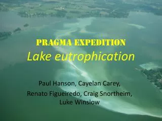
Lake Eutrophication Change Detection for the Management of Water Resources Michelle L. Aten and Greg Easson University of Mississippi Geoinformatics Center Multi-Temp 2005
Partners • NASA • World Summit for Sustainable Development • Objectives Module 3 – Disaster Management and Conflicts • Natural and Human Induced Disasters • Water Resources • European Space Agency • TIGER initiative • South African Division of Water Affairs and Forestry • National Eutrophication Monitoring Programme
Overview • Eutrophication • Tropic level of lake increases • Nutrient enrichment, especially phosphorus • Available oxygen decreases • May become toxic • Unsuitable for consumption • May lead to growth of aquatic macrophytes
Overview • Anthropogenic Causes • Agricultural practices • Industrial activity • Residential development • Effects on Society • Requires filtering of water supply • May result in water supply interruption • Impacts recreational uses of reservoir
Benefits • System for advanced warning of eutrophication • Decision support for policy makers • Alternatives for nations without water resource monitoring infrastructures
Deliverables • Comprehensive watershed characterization • Web enabled GIS data portal • Educational materials • Operational solution for resource monitoring • Joint publications and presentations
Study Site • Hartbeespoort Lake, South Africa • 20 sq km • 50 km N Johannesburg • 35 km W Pretoria
Earth Observation Data ASTER MODIS Landsat 5 TM Landsat 7 ETM+ SRTM ASAR MERIS Field Data Surface Sample: Chlorophyll a Integrated 0-5m Sample: Chlorophyll a Field verification GIS Data Soils DEM Classification Data
Watershed Models • USDA – National Sedimentation Lab • AnnAGNPS – Annualized Agricultural Non-Point Source • NOAA • N-SPECT – Non-Point Source Pollution and Erosion Comparison Tool
Selection Criteria • International scope • Requires inputs from available data • Reliability • Ease of Use • Iterative analysis tools • Cost effective • Validation options
Basin Characterization • Input Data • DEM • Soils Maps • In-situ Data • Land Use/Land Cover Maps • Output Data • Hydrology • Nutrients
Acknowledgements • Division of Water Affairs and Forestry, National Eutrophication Monitoring Programme • NASA, Stennis Space Center • European Space Agency
The University of Mississippi Geoinformatics Center www.umgc.olemiss.edu aten@olemiss.edu