Geocoding and Census Mapping: Conceptual Framework and Different Approaches
Geocoding and Census Mapping: Conceptual Framework and Different Approaches. Lisa Jordan Florida State University Department of Geography, Center for Demography and Population Health. Geographic census data are valuable.

Geocoding and Census Mapping: Conceptual Framework and Different Approaches
E N D
Presentation Transcript
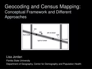
Geocoding and Census Mapping:Conceptual Framework and Different Approaches Lisa Jordan Florida State University Department of Geography, Center for Demography and Population Health
Geographic census data are valuable Planning of social and educational services, poverty analysis, utility service planning, labor force analysis, marketing analysis, voting district delineation, emergency planning, epidemiology analysis, flood plain analysis, and agriculture (including famine early warning systems) Planning of social and educational services, poverty analysis, utility service planning, labor force analysis, marketing analysis, voting district delineation, emergency planning, epidemiology analysis, flood plain analysis, and agriculture (including famine early warning systems) Planning of social and educational services, poverty analysis, utility service planning, labor force analysis, marketing analysis, voting district delineation, emergency planning, epidemiology analysis, flood plain analysis, and agriculture (including famine early warning systems) Planning of social and educational services, poverty analysis, utility service planning, labor force analysis, marketing analysis, voting district delineation, emergency planning, epidemiology analysis, flood plain analysis, and agriculture (including famine early warning systems) Planning of social and educational services, poverty analysis, utility service planning, labor force analysis, marketing analysis, voting district delineation, emergency planning, epidemiology analysis, flood plain analysis, and agriculture (including famine early warning systems)
Nighttime Lights: Surface Modeling: Land-use: IKONOS Roads GRUMP: Land-use: Landsat Land-use: Landsat GPW elevation NPP LandScan: railways cities roads land-use Reibel and Bufalino, 2005
Growing Open Source and Public Application of Census Information Public, web-based geocoding and GIS, batchgeocode.com
Growing Open Source and Public Application of Census Information San Francisco, population, census block groups San Francisco, population, interpolated gCensus, by Imran Haque, gCensus – GT, allows import of raster files, GeoTiffs, for example
Growing Open Source and Public Application of Census Information • QGIS • MapWindow • uDig • Saga
Geocoding Concepts • Address Matching • Assignment to Enumeration Areas
Geocoding Concepts Census Hierarchy Address Hierarchy
Geocoding Concepts Applications and Limitations pre-enumeration enumeration post-enumeration
Suggested Updates to the Handbook • Updates on software/hardware discussion - mentioning the potential advantages of investing in open source GIS • Include suggestions for assessing data quality, such as the geocoding certainty indicator (GCI) (Davis and Fonseca 2007) • More and updated case studies (as presented here this week) • Perhaps mention the valuable role of the United Nations in facilitating an international spatial data infrastructure that brings disparate national information together