Download
1 / 130
1.3k likes | 1.69k Views
SOUTHERN AND EASTERN ASIA: GEOGRAPHIC UNDERSTANDINGS SS7G9 The student will locate selected features in southern and eastern Asia.

E N D
SOUTHERN AND EASTERN ASIA:GEOGRAPHIC UNDERSTANDINGSSS7G9The student will locate selected features in southern and eastern Asia Locate on a world and regional political-physical map: Ganges River, Huang He (Yellow River), Indus River, Mekong River, Yangtze (Chang Jiang) River, Bay of Bengal, Indian Ocean, Sea of Japan, South China Sea, Yellow Sea, Gobi Desert, Taklimakan Desert, Himalayan Mountains, and Korean Peninsula.
The southern and eastern parts of Asia are home to almost half of the world's population. The geography of this large area is varied, containing some of the world’s longest rivers, highest mountain ranges, and largest deserts.
The Indus River begins in the mountains of Tibet and flows almost 2,000 miles through the country of Pakistan before emptying into the Arabian Sea. The Indus River valley is one of the richest farming areas in this region. Many different civilizations have lived along this river throughout the centuries.
The Ganges [gan-jeez] River is India’s most important river. It begins in the Himalayan Mountains and flows southeast through India and Bangladesh before emptying into the Bay of Bengal. The water of the Ganges carries tons of rich sediment (topsoil, silt, and minerals from the mountains) that is gradually spread along its path enriching the farmland and creating a large, fertile delta at the mouth of the river.
Because so many people live and work along the Ganges, the water in the river is heavily polluted. The Indian government recently declared the badly polluted Ganges River a national heritage site and committed to cleaning up the waters, holy to Hindus, which are used by hundreds of millions of people each day to bathe and to wash clothes.
The country of Bangladesh is located almost completely in the Ganges River delta. Heavy flooding in this part of the world during monsoon season (a seasonal prevailing wind, lasting several months which brings heavy rains) often causes great hardships for those living in this country. Further out to sea is the Indian Ocean, which is the third largest ocean in the world.
The Himalayan Mountains form the southern border of China. This high ground spreads to the north to form the Tibetan Plateau. The area is sometimes called “the roof of the world” because of its high altitudes. This wide area of mountains and high plateau blocks any moisture coming from the rivers and seas to the south.
The Himalayan Mountains form India’s eastern border with China and Nepal. These high mountains form a barrier between India and countries to the north and east. The Himalayan Mountains stretch for almost 200 miles. The highest mountain in the world, Mount Everest, is on the border between Nepal and China. Mt. Everest, above, is 29,035 ft. high and was formed about 60 million years ago. There are about 120 corpses of failed hikers still on the mountain
As the mountains begin to level off in the north, the land becomes desert. Here one finds the Taklimakan Desert and the Gobi Desert. The Taklimakan Desert [tah-kluh-muh-kahn]in western China is over 600 miles in length, one of the longest deserts in the world. Above left: The Taklimakan Desert is a vast, dry sandy wasteland. Pyramid-shaped sand dunes tower 300 meters above the plains. The name means “can’t get out once you come in.” Right: Mummy found in Taklimakan dates from 4000-2300 years ago.
To the west and in the central part of China is the Gobi [go-bee] Desert, which can be one of the hottest and one of the coldest places in the world. Much of the Gobi Desert is covered with sand and rocks.
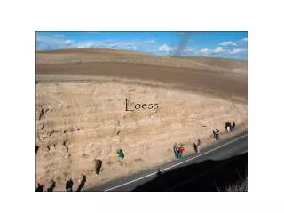
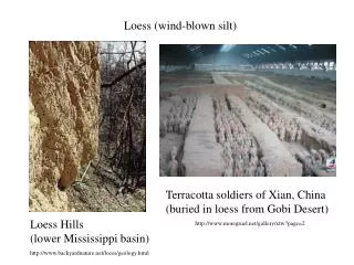
China’s fertile farming areas lay north and east of this great desert region. The Huang He (hwang ●he) or Yellow River, begins in the mountainous plateau of Tibet, It flows toward the east and finally empties into the Yellow Sea. The yellow dust blowing out of the Gobi Desert is picked up by the Huang He and is carried along as loess (lus or lō●uhs), or silt, giving both the river and the sea a yellowish color.
Loess is also deposited along the river’s path, creating rich soil for the farmers in the area. This river is also used for transporting people and goods, though sometimes annual floods make conditions along the river’s path dangerous. The frequent flooding has led some to call the Huang He “China’s Sorrow.” Loess (silt) is what gives the Yellow River (above) its name and its color.
The Yangtze [yang-see] River or Chang Jiang also begins in the Tibetan Plateau. This river travels east until it reaches the East China Sea. Shanghai, one of China’s most important ports, is located at the mouth of this river. The Yangtze River is over 3,400 miles long making it China’s longest river.
The Yangtze goes through fertile farming land and is one of China’s main transportation routes. The Yangtze and Huang He are connected by the Grand Canal, one of the world’s oldest and longest canal systems. The oldest parts of the canal were built over 2,000 years ago. Above: photos of China’s Grand Canal
The Mekong [mey-kong] River begins in the Tibetan Plateau. This river runs south from China through Myanmar (MEE-ahn-mar or my-AHN-mar), formerly Burma, Thailand (TIE-land), Laos (lous), Cambodia, and finally, Vietnam, where it empties into the South China Sea. It’s the longest river in southeast Asia. The Mekong River delta has some of the richest farming land in the world.
The Korean Peninsula is a mountainous peninsula (a body of land surrounded by water on three sides). It’s attached to China and bordered by the Yellow Sea and the Sea of Japan. Over half of the peninsula is made up of mountains. Even though so much of the country is mountainous, there is still plenty of rich farmland.
Since the end of World War II, Korea has been divided into two different countries, North Korea and South Korea. North Korea is Communist and is separated from South Korea, which is supported by the U.S., by the demilitarized zone or DMZ, shown on the map below.
The Sea of Japan is a small sea bound by Russia to the north, the Korean Peninsula to the west, and Japan to the east.
SS7G9 The student will locate selected features in Southern and Eastern Asia. b. Locate on a world and regional political-physical map the countries of China, India, Indonesia, Japan, North Korea, South Korea, and Vietnam.
Below is a map of southern and eastern Asia. Are you able to locate the countries of China, India, Indonesia, Japan, North Korea, South Korea, and Vietnam?
SS7G10The student will discuss environmental issues across Southern and Eastern Asia.a. Describe the causes and effects of pollution on the Yangtze and Ganges Rivers.
THE GANGES RIVERThe Ganges [gan-jeez] River begins high in the Himalayan Mountains and flows 1600 miles through India and Bangladesh to the Bay of Bengal. This river provides water and transportation for the over 400 million people who live in its river valley.It’s known as “Mother Ganges.”
In spite of the Ganges’ importance and its place in the spiritual lives of Indians, the quality of the water has become poor. Chemicals used in fertilizer and industry are washed into the river everyday. Human and animal waste also foul the river.
The bodies of dead animals as well as the cremated remains of human beings (bodies that are burned after death and whose ashes are scattered in the river)regularly float down the river. In spite of this, many Indian Hindus bathe in the Ganges because they believe it’s holy and will wash away sins and grant immortality. They also use the water for drinking and cooking.
Cities along the Ganges have the highest rates of water-born diseases, which are diseases found in water, of any people who live in India. Still, these cities pour millions of gallons of sewage, or water that contains waste products, into the river to be carried to cities and villages farther south. Outbreaks of diseases like cholera, dysentery, and hepatitis are common. Most officials say polluted water is part of the reason. The above image shows a corpse floating in the Ganges.
India did begin a program called the Ganges Action Plan in 1985 to try to clean up the river. Many sewage and water treatment plants have been built along the river. However, the growing population of India, around 1 billion people, and the run-off from industrial and farm production have meant that clean-up efforts fall short of what is needed.
THE YANGTZE RIVERChina’s longest river, the Yangtze [yang-see] River, flows almost 4,000 miles through over 185 towns where almost 400 million people live. Pumping stations along the river take water out to supply people with water for drinking, irrigation, and industrial uses.
Millions of gallons of sewage (refuse liquids and waste matter carried off by sewers) are dumped into the Yangtze, along with chemicals from agricultural runoff and industrial wastes. Nitrogen from fertilizers and arsenic, a poison, from industrial uses are leading pollutants found in the Yangtze’s waters. Above left: Trash floats on this stretch of river in Chongqing, China. The World Wide Fund for Nature estimates the river getsmore than half of China's sewage and industrial waste. Right: Untreated industrial sewage from a textile dyeing factory is drained into the Yangtze River in Yichang, central China's Hubei Province.
The pollution in the river puts all the cities along its bank at risk. Many species of plants and animals that once lived in the rivers are disappearing. The high levels of nitrogen and phosphates lead to the growth of blue-green algae. This growth reduces the oxygen in the water causing fish to die. Contaminated fish are caught and eaten by the Chinese people, leading to other health problems. Middle photo: A resident scoops up a bowl of foul-smelling, polluted river water. Left and Right: Water supplies to about 200,000 people in central China have been contaminated by pollution, which has turned branches of the Yangtze River system red.
China is building more water treatment facilities which would treat the water and remove contaminants. It’s encouraging cities along the river to build sanitary landfills where trash and waste would be isolated from the environment until it’s safe rather than dumping garbage in the river. International organizations like the World Bank have worked with Chinese authorities to organize such programs.
The massive Three Gorges Dam was built along the Yangtze River in central China to provide hydroelectric power to millions of Chinese who have not had electricity. The Three Gorges Dam on the Yangtze River is one of the largest construction projects ever undertaken by mankind. The Chinese government finally gave its approval to launch the project in 1992, some seventy years after Sun Yat-sen first proposed the idea. It was to be completed in 2009. It will provide China with tremendous power generation and flood control.
Some people feel that the Three Gorges Dam project was begun without taking into account the effects such a project would have on the environment. A number of plant and animal species that live along the river where the dam has been built are now threatened with extinction. Another concern is that the dam has been built in an area prone to earthquakes. The above image shows the Three Gorges Dam, the largest dam in the world, in the early morning mist.
SS7G10The student will discuss environmental issues across southern and eastern Asia.b. Describe the causes and effects of air pollution and flooding in India and China.
INDIAAir pollution is one of India’s most serious environmental problems.An enormous and growing population along with the rapid growth of cities (urban areas) and the development of industry have left many parts of India with some of the heaviest air pollution in the world. Above images show air pollution in India which kills 5 million people each year.
Indians living in several major cities have some of the highest rates of respiratory disease in the world. These kinds of diseases effect the lungs, bronchial tubes, and trachea.
In addition to industrial smoke, the growing number of automobiles and trucks in India contribute to the poor air quality. Some estimates say that automobile emissions like carbons and other chemicals that come from a car’s engine are responsible for almost 70% of the air pollution in some urban areas of India.
Many people in India are poor. They don’t want to do anything that would slow down their country’s economic growth. For this reason, it’s been difficult for the Indian government to enforce many of the laws on industry and transportation that might improve the country’s air.
In rural areas, many families cook over open fires, using wood, animal dung, or coal as fuel. These fuel sources send carbon monoxide, soot, and many different chemicals into the air as well. The air inside the home is often as bad as the outside air. This pollution can form a haze known as brown cloudswhich reduce rainfall and temperatures. New research suggests that cow dung used by millions of people in India for cooking fires may be adding to the arsenic poisoning epidemic. Right: Wood fires cook slowly and the smoke causes glaucoma and lung diseases mainly for the women and children.
CHINAWhen the Olympic committee decided to have the 2008 Olympic Games in Beijing, one of the concerns among the athletes who were going to compete was the quality of the air in that Chinese city. Beijing was dubbed the “Air Pollution Capitol of the World.” Like many other major Chinese cities, it had experienced tremendous growth in both population and industry during the past few decades.
Much of China’s energy is provided by burning coal, a process that sends tons of soot, ash, and chemicals into the atmosphere. In addition, millions of Chinese people now drive automobiles and trucks and that exhaust is another source of massive air pollution. China is the second-largest producer of greenhouse gases.
According to the People’s Republic of China’s own statistics, the leading causes of death in that country are respiratory and heart diseases that can be tied to long exposure to air pollution.
Airborne pollution also contributes to acid rain, a problem for at least a third of China’s agricultural areas. Acid rain occurs when chemicals in the air, especially sulfur dioxide and nitrogen oxides that come from burning fossil fuels like coal, react with the moisture in the atmosphere and fall to the ground as rain containing sulfuric acid and nitric acid. Acid rain is harmful to plants, animals, and even buildings.
Before the 2008 Olympics, the Beijing Municipal Environmental Protection Bureau was established to work on the quality of the city’s air. Automobile traffic was greatly reduced and many factories were temporarily closed. As a result, many major air pollutants were reduced by as much as 45%.
Many people living in Beijing want the government to find ways to keep pollution down while still allowing for economic progress. Leaders at the World Bank make the argument that the expenses of health problems tied to air pollution are far greater than those industries and activities that contribute to the pollution.
The impact of environmental and health problems related to air and water pollution take many years to show up in the general population. Often governments begin clean-up efforts long after the health of a country’s population has begun to suffer.
Because China and India have such enormous populations, almost one-half of all the people on earth, attention to health issues related to air and water pollutionare of critical importance.
SS7G11The student will explain the impact of location, climate, physical characteristics, distribution of natural resources, and population distribution on southern and eastern Asia.a. Describe the impact climate and location has on population distribution in southern and eastern Asia.
The climates of most of the countries in southern and eastern Asia vary depending on each country’s geography. Nearby oceans, mountains, deserts, latitude, and wind patterns affect climate.
INDIAIndia has many types of climates. Snow and ice are in the northern mountains, hot, dry plains are in the central plateau, and steamy tropical weather is along the southern coast. Along the mountain ranges to the north, the temperatures are like those in other high altitude locations. Some of the highest peaks are covered with ice and snow.
A large desert area borders Pakistan, while the Ganges Plain is humid and almost tropical. The Deccan Plateau in the center of the country is more moderate, with a subtropical coastal plain along the Indian Ocean.