Download
1 / 27
300 likes | 586 Views
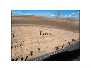
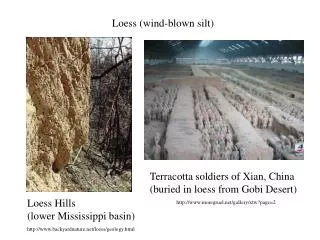
Loess (wind-blown silt). Terracotta soldiers of Xian, China (buried in loess from Gobi Desert). Loess Hills (lower Mississippi basin). http://www.moregruel.net/gallery/xtw?page=2. http://www.backyardnature.net/loess/geology.html. Alluvial fan (Death Valley, CA).

E N D
Loess (wind-blown silt) Terracotta soldiers of Xian, China (buried in loess from Gobi Desert) Loess Hills (lower Mississippi basin) http://www.moregruel.net/gallery/xtw?page=2 http://www.backyardnature.net/loess/geology.html
Alluvial fan (Death Valley, CA) Very coarse, high K, high n, but water table often at great depth. (Water drains right through) http://www2.nature.nps.gov/geology/usgsnps/deva/rfan.html
Braided river gravel deposits make excellent aquifers! Chitina River, Alaska (from Press & Siever, 1998) River gravel
Meandering river Near Anchorage, Alaska From Press and Siever (1998) silt and clay sand bar
Delta: mainly fine sand, silt and clay… low-med K units mostly http://www.mbarron.net/Nile/sat-delta.jpg
Glacial deposits (till) In front of the end moraine, glacial meltwater reworks the till and forms broad sheetlike deposits of sand & gravel (outwash plain). Excellent aquifer. http://mantei.smsu.edu/glg110/glaciers.html
Glacial till forms a blanket-like deposit beneath a glacier. Till usually consists of boulders in a finer matrix of silt and clay. It will usually have low K unless the deposit has been reworked by wind or water. http://mantei.smsu.edu/glg110/glaciers.html
Lateral and medial moraines (Press et al.) Moraines form at the edges and terminus of alpine or continental glaciers. They are rich in boulders and gravel, and if re-worked by rivers or glacial meltwater (or ocean currents) they can be very good aquifers. http://www.zephryus.demon.co.uk/geography/resources/glaciers/moraine.html#top
End moraines The Oak Ridges Moraine (ORM) near Toronto is another end moraine. This gravel deposit has a unique habitat of wetlands and fresh lakes, and is also an important gw supply for metropolitan Toronto. Long Island, N.Y. is a good example of highly permeable sands & gravels left behind as a recessional end moraine near the end of the Wisconsin ice age http://www.conncoll.edu/ccrec/greennet/arbo/publications/34/CHP1.HTM
Eskers are rivers of sand and gravel that formed when a meltwater channel beneath a continental glacier fills with sediment. They are excellent sources of gw, but are limited in size. Commonly mined for gravel. Press et al.
Glacial lake sediments (glacio-lacustrine) Glacial lake sediments typically contain a lot of clay, but may be interlayered on a cm scale with sand and silt. The layers are called “varves”, and reflect alternating seasons. In winter the lakes and surrounding rivers are frozen, and clay is deposited. In summer, swollen rivers dump silt & sand into the lakes.
Pingos “Open-system pingos form when groundwater flows downhill and is trapped underneath the permafrost. Eventually the water forces itself up through cracks into the permafrost and freezes, pushing the soil above it up into a dome” http://www.taiga.net/yourYukon/col171.html
Prince Edward Island Bedrock = “redbed” sandstone and conglomerate (Carboniferous age) PEI gets 100% of its drinking water from gw in the fractured sandstone. They have abundant supplies. Total use is < 2% of total annual recharge. Main problems related to pollution.
Limestone karst features Press et al., “Understanding Earth”
tower karst in China (near Guilen) http://www.imperialtours.net/karst_scenery.htm tower karst in Thailand http://www.siue.edu/GEOGRAPHY/ONLINE/MGfig5.jpg
USGS hydrogeologist injecting rhodamine dye to see where water in a sinking stream turns up. http://water.usgs.gov/ogw/karst/karstphotos.htm
Sinkholes (collapsed cave roof) In rural areas, sinkholes are popular places to throw trash. Is this a good idea?
Floridan Aquifer http://capp.water.usgs.gov/gwa/ch_g/G-Floridan.html Brown = confined Blue = unconfined Shows thickness of limestone aquifer.
Light blue is high purity water. Purple is saline. Red areas show areas where Floridan aquifer has been drawn down from withdrawels.
Edwards Aquifer (south Texas) http://www.edwardsaquifer.net/geology.html
Pacific NW basalt-rock aquifers Includes Columbia River and Snake River flood basalts http://capp.water.usgs.gov/aquiferBasics/volcan.html
A lava tube During cooling, basalt flows develop characteristic fracture patterns that increase K and n of rock. K is also increased by interflow sediments (loess, sand) and lava tubes/tunnels.
Columnar joints in andesite lava flow (Patagonia)… …and in a sub-volcanic intrusion Devil’s Tower, Wyoming In general, lava flows and welded tuff have higher permeability than non-welded pyroclastic rock (tuff and ash). Much of the porosity is fracture or joint-controlled. Non-welded tuff doesn’t fracture easily, and can have a very high clay content. Layers of ash that fall 100’s of miles from the volcano can compact to form very low-K confining layers surrounded by otherwise hi-K sediments.
Pyroclastic volcanic rock Non-welded tuff (Very low K … this tilted outcrop is being mined for bentonite, or “swelling clay”) Welded tuff (fractures easily… good secondary permeability)
For plutonic and metamorphic rocks, gw storage and permeability is totally controlled by presence or absence of secondary fractures. Look for lineaments from air photos for location of major faults or fracture zones that have higher gw yield. http://geoweb.tamu.edu/courses/geol101/heaney02/Chapter5/sld016.htm
http://geoweb.tamu.edu/courses/geol101/heaney02/Chapter5/sld016.htmhttp://geoweb.tamu.edu/courses/geol101/heaney02/Chapter5/sld016.htm Humbug Spires (Butte, MT)
Permeability of regional metamorphic rocks can be strongly anisotropic, due to development of foliation (slaty cleavage, schistosity, gneissic banding).