National Land Cover Database (NLCD 2001)
180 likes | 329 Views
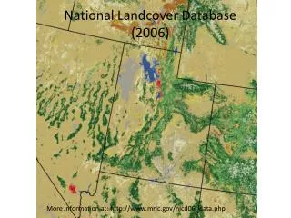
National Land Cover Database (NLCD 2001). Jan 30, 07. 3 products. Landcover Impervious surface Forest canopy. NLCD Landcover. NLCD Landcover. NASS 2001. NLCD Landcover. NASS 2001. NLCD Landcover. NLCD Forest Canopy. NLCD Impervious Surface. NLCD Impervious Surface. NLCD

National Land Cover Database (NLCD 2001)
E N D
Presentation Transcript
National Land Cover Database (NLCD 2001) Jan 30, 07
3 products • Landcover • Impervious surface • Forest canopy
NLCD Landcover
NLCD Landcover
NASS 2001
NLCD Landcover
NASS 2001
NLCD Landcover
NLCD Forest Canopy
NLCD Impervious Surface
NLCD Impervious Surface
NLCD Impervious Surface
Where is this data? • abegis/indiana/landuse/nlcd_2001_f Map the drive: \\pasture.ecn.purdue.edu\abegis Then navigate to ./indiana/landuse/nlcd_2001_f
SCALE means layers for INDIANA are in one place, layers for all USA in another; Layers for one county are in “county,” etc. GIS data is organized by SCALE, then by TYPE