Calculating Elevations for a Crest Vertical Curve in Road Design
This document outlines the process of determining the elevations and stations for a crest vertical curve with a length of 400 ft, connecting grades of +1.0% and -1.75%. The Vertical Point of Intersection (VPI) is found at station 35+00 with an elevation of 549.2 ft. The calculations yield the elevation of the Vertical Point of Curvature (VPC) at 547.20 ft and the Vertical Point of Tangent (VPT) at 545.70 ft. The respective stations for VPC and VPT are calculated accordingly, ensuring a smooth transition between grades in road design.

Calculating Elevations for a Crest Vertical Curve in Road Design
E N D
Presentation Transcript
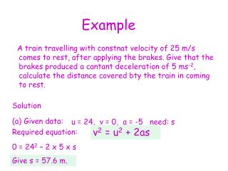
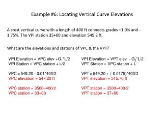
Example #6: Locating Vertical Curve Elevations A crest vertical curve with a length of 400 ft connects grades +1.0% and -1.75%. The VPI station 35+00 and elevation 549.2 ft. What are the elevations and stations of VPC & the VPT? VPI Elevation = VPC elev +G1*L/2 VPI Station = VPC station + L/2 VPC=549.20 - 0.01*400/2 VPC elevation = 547.20 ft VPC station = 3500–400/2 VPC station = 33+00 VPI Elevation = VPT elev - G2*L/2 VPT Station = VPC station + L VPT=549.20 + (-0.0175)*400/2 VPT elevation = 545.70 ft VPT station = 3500+400/2 VPT station = 37+00